Vernon
No
No
Yes
Fish and Aquatic Life
Overview
The Bad Axe River, located in southwestern Vernon County, flows in a westerly direction for approximately five miles before reaching the Mississippi River south of Genoa. The lower end of the Bad Axe River flows through the Upper Mississippi National Wildlife Refuge and the Genoa National Fish Hatchery. It has a slight gradient of less than 20 feet per mile and drains steep forests, agricultural land, and lowland pasture. Approximately 370 acres of wetland adjoin the lower end of the Bad Axe River near the Mississippi River. The Bad Axe River is not a classified trout stream, but contains warm water sport fish.
The most recent survey, completed in 1960, documented a 60 foot wide river averaging over four feet deep. Low mud flats, steep eroding banks and forested bank cover were observed. The fish found in the Bad Axe River were all species common to the Mississippi River such as northern pike, sauger, largemouth bass, white crappie, black crappie, freshwater drum, mooneye and northern redhorse. A fishery survey should be conducted to update the biological information available for the Bad Axe River. No WDNR stocking records exist for the Bad Axe River. Access to the river is from three road crossings and the Upper Mississippi River National Fish and Wildlife Refuge.
From: Koperski, Cindy. 2002. The State of the Bad Axe - La Crosse Basin. Wisconsin Department of Natural Resources, Madison, WI
Date 2002
Author Cynthia Koperski
Historical Description
Bad Axe River. T21N. R7W. Section 160 Surface Acres = 32.9. Miles = 4.6. Gradient = less than 20 feet
per mile.
This hard water stream flows in a westerly direction and joins the Mississippi River about two and three-quarter miles north of Victory. At the time of survey, the water was turbid. Sauger, northern pike, largemouth bass, white crappie, black crappie, mooneye, freshwater drum (sheepshead), redhorse, gizzard shad, white sucker, carp, and numerous small minnow species comprise the fishery. Sand is the dominant bottom type, with some silt and small amounts of detritus, clay, gravel, and rubble. The lower end of the stream flows through the Upper Mississippi National Wildlife Refuge, and the Genoa National Fish Hatchery has land bordering the stream. Three roads cross the stream. There are about 371 acres of adjoining wetlands. Wildlife includes muskrat, beaver, nesting mallards, teal, and wood ducks, and considerable numbers of migrant puddle and diving ducks.
From: Klick, Thomas A. and Threinen, C.W. 1973. Lake and Stream Classification Project. Surface Water Resources of Vernon County, Wisconsin Department of Natural Resources, Madison, WI.
Date 1973
Author Surface Water Inventory Of Wisconsin
Impaired Waters
Bad Axe River (1639300) was assessed during the 2016 listing cycle; total phosphorus sample data exceed 2016 WisCALM listing criteria for the Fish and Aquatic Life use, however, available biological data do not indicate impairment (i.e. no macroinvertebrate or fish Index of Biotic Integrity (IBI) scored in the "poor" condition category).
Date 2015
Author Aaron Larson
Condition
Wisconsin has over 84,000 miles of streams, 15,000 lakes and milllions of acres of wetlands. Assessing the condition of this vast amount of water is challenging. The state's water monitoring program uses a media-based, cross-program approach to analyze water condition. An updated monitoring strategy (2015-2020) is now available. Compliance with Clean Water Act fishable, swimmable standards are located in the Executive Summary of Water Condition in 2018. See also the 'monitoring and projects' tab.
Reports
Recommendations
Monitor Fish Community
Conduct biological monitoring, wbic 1639300 to evaluate TP impacts
Water Quality Planning
Basin Planning
Stormwater Planning, Implementation
Increased runoff volumes from expanding urban areas in the basin threaten not only the quality but also the future existence of adjacent trout streams. The change in stormwater runoff volume as well as when and how much of it reaches an adjacent stream can degrade the in-stream habitat and water temperatures necessary for trout survival.
Urban Growth Planning
Development encroaching into the extensive lower La Crosse River wetland complex threatens not only the flood control function, but also the diversity of plant and animal species residing within. Requests to fill one acre here and a half acre there of the La Crosse River marsh contributes to the cumulative reduction in total area.
Runoff Grant
Beach closings due to unsafe bacterial levels in rivers and in some impoundments are of concern. Due to the topographic constraints of many farms in the basin, many barnyards and feedlots are immediately adjacent to streams. If not properly managed, these areas can contribute large amounts of bacteria laden manure to a stream.
Management Goals
Wisconsin's Water Quality Standards provide qualitative and quantitative goals for waters that are protective of Fishable, Swimmable conditions [Learn more]. Waters that do not meet water quality standards are considered impaired and restoration actions are planned and carried out until the water is once again fishable and swimmable
Management goals can include creation or implementation of a Total Maximum Daily Load analysis, a Nine Key Element Plan, or other restoration work, education and outreach and more. If specific recommendations exist for this water, they will be displayed below online.
Monitoring
Monitoring the condition of a river, stream, or lake includes gathering physical, chemical, biological, and habitat data. Comprehensive studies often gather all these parameters in great detail, while lighter assessment events will involve sampling physical, chemical and biological data such as macroinvertebrates. Aquatic macroinvertebrates and fish communities integrate watershed or catchment condition, providing great insight into overall ecosystem health. Chemical and habitat parameters tell researchers more about human induced problems including contaminated runoff, point source dischargers, or habitat issues that foster or limit the potential of aquatic communities to thrive in a given area. Wisconsin's Water Monitoring Strategy was recenty updated.
Grants and Management Projects
Monitoring Projects
| WBIC | Official Waterbody Name | Station ID | Station Name | Earliest Fieldwork Date | Latest Fieldwork Date | View Station | View Data |
|---|
| 5588257 | Unnamed | 10033140 | Unnamed | 7/5/2009 | 9/2/2016 | Map | Data |
| 5030088 | Unnamed | 10033140 | Unnamed | 7/5/2009 | 9/2/2016 | Map | Data |
| 5030088 | Unnamed | 10035242 | Bad Axe River - Area of Open Water - Area of Open Water | | | Map | Data |
| 1639300 | Bad Axe River | 10017466 | Bad Axe River -- Access | 6/12/2010 | 6/12/2010 | Map | Data |
| 1639300 | Bad Axe River | 10055790 | Mississippi River-Pool 9-Confluence with Badaxe River | | | Map | Data |
| 5588235 | Unnamed | 10033139 | Unnamed | 7/5/2009 | 9/2/2016 | Map | Data |
| 1639300 | Bad Axe River | 10022505 | Bad Axe River - Old Steel Bridge Below Willenberg Rd. | | | Map | Data |
| 1639300 | Bad Axe River | 10035242 | Bad Axe River - Area of Open Water - Area of Open Water | | | Map | Data |
| 5588257 | Unnamed | 10035242 | Bad Axe River - Area of Open Water - Area of Open Water | | | Map | Data |
| 5588257 | Unnamed | 10017465 | Bad Axe River/Mississippi River -- Landing | 6/8/2015 | 6/28/2020 | Map | Data |
| 1639300 | Bad Axe River | 633072 | Bad Axe River - Near Mouth (at Willenberg Road Bridge) | 7/2/1991 | 1/1/2015 | Map | Data |
| 1639300 | Bad Axe River | 10033140 | Unnamed | 7/5/2009 | 9/2/2016 | Map | Data |
|
Watershed Characteristics
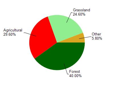
Bad Axe River is located in the Bad Axe River watershed which is 195.49 mi². Land use in the watershed is primarily forest (40%), agricultural (29.60%) and a mix of grassland (24.60%) and other uses (5.80%). This watershed has 468.27 stream miles, 489.81 lake acres and 2,552.28 wetland acres.
Nonpoint Source Characteristics
This watershed is ranked High for runoff impacts on streams, Not Ranked for runoff impacts on lakes and Low for runoff impacts on groundwater and therefore has an overall rank of Low. This value can be used in ranking the watershed or individual waterbodies for grant funding under state and county programs.However, all waters are affected by diffuse pollutant sources regardless of initial water quality. Applications for specific runoff projects under state or county grant programs may be pursued. For more information, go to surface water program grants.