Trempealeau
No
No
Yes
Fish and Aquatic Life
Overview
Lake Marinuka is a 98 acre impoundment of Beaver Creek in Galesville. The impoundment was created by the construction of a mill dam in 1867. The impoundment originally had a surface area of approximately 240 acres. Sedimentation decreased the surface area to approximately 135 acres by the 1930's and to 70 acres by 1978.
The Lake Marinuka Protection and Rehabilitation District conducted a feasibility study and developed a rehabilitation plan between 1975 and 1979. The rehabilitation plan identified lake dredging and watershed improvements to reduce sediment and nutrient delivery to the lake as project objectives. The plan was implemented between 1981 and 1986. Dredging involved removal of approximately 590,000 cubic yards of sediment from 45 acres of the lake. Watershed improvements focused on riprapping 16,500 feet of eroding streambanks (EPA).
A lake planning grant will be used to conduct sediment core analysis as well as lake design and dredge disposal design for dredging to be conducted in 1999. Protection of the impoundment from sedimentation and habitat enhancement for waterfowl and fish will be accomplished with the dredging project. Approximately 40-50,000 cubic yards will be removed from the lake (Sorge).
Lake Marinuka and Beaver Creek likely support a healthy Blanding’s turtle population, a Wisconsin threatened species. Conducting drawdowns after hibernation can result in heavy winter mortality due to desiccation and freezing. To minimize winter mortality of this species, it is recommended that any planned drawdowns of the lake be completed prior to October 1.
A consumption advisory exists for mercury in largemouth bass found in Lake Marinuka. Due to the fish advisory, Lake Marinuka is on the 1998 Wisconsin impaired waters (303(d)) list provided to the United States Environmental Protection Agency.
Date 1999
Author Aquatic Biologist
Historical Description
This hard water, drainage impoundment is located on Beaver Creek within the City of Galesville. The dam is privately owned and has a height of 17 feet. The water is alkaline, clear, and has a low transparency. Largemouth bass, bluegill, crappie, pumpkinseed, and bullhead comprise the fishery. An occasional brown trout or walleye may be taken by anglers. Walleye were stocked following chemical treatment of Beaver Creek from Ettrick to the dam at Galesville in 1964. The purpose of the fish eradication project was to remove an abundance of carp and forage fish species. Aquatic vegetation, including algae, is a problem and chemical treatment has been used as a control measure. There is public access. Game values include beaver and muskrat, nesting mallard and teal, and use of the water by a fair number of migrant puddle ducks.
Source: 1970, Surface Water Resources of Trempealeau County Marinuka Lake, T19N, R8W, S28 Surface Acres = 107.2, S.D.F. = 1.65, Maximum Depth = 9 feet.
Date 1970
Author Aquatic Biologist
Impaired Waters
Marinuka Lake (1678200) was placed on the impaired waters list for Mercury in 1998 and for total phosphorus in 2010. The 2016 assessments showed continued impairment by phosphorus; total phosphorus sample data exceed 2016 WisCALM listing thresholds for the Recreation use and Fish and Aquatic Life use. Based on the most updated information, no change in existing impaired waters listing is needed.
Date 2015
Author Aaron Larson
Condition
Wisconsin has over 84,000 miles of streams, 15,000 lakes and milllions of acres of wetlands. Assessing the condition of this vast amount of water is challenging. The state's water monitoring program uses a media-based, cross-program approach to analyze water condition. An updated monitoring strategy (2015-2020) is now available. Compliance with Clean Water Act fishable, swimmable standards are located in the Executive Summary of Water Condition in 2018. See also the 'monitoring and projects' tab.
Reports
Recommendations
Management Goals
Wisconsin's Water Quality Standards provide qualitative and quantitative goals for waters that are protective of Fishable, Swimmable conditions [Learn more]. Waters that do not meet water quality standards are considered impaired and restoration actions are planned and carried out until the water is once again fishable and swimmable
Management goals can include creation or implementation of a Total Maximum Daily Load analysis, a Nine Key Element Plan, or other restoration work, education and outreach and more. If specific recommendations exist for this water, they will be displayed below online.
Monitoring
Monitoring the condition of a river, stream, or lake includes gathering physical, chemical, biological, and habitat data. Comprehensive studies often gather all these parameters in great detail, while lighter assessment events will involve sampling physical, chemical and biological data such as macroinvertebrates. Aquatic macroinvertebrates and fish communities integrate watershed or catchment condition, providing great insight into overall ecosystem health. Chemical and habitat parameters tell researchers more about human induced problems including contaminated runoff, point source dischargers, or habitat issues that foster or limit the potential of aquatic communities to thrive in a given area. Wisconsin's Water Monitoring Strategy was recenty updated.
Grants and Management Projects
Monitoring Projects
| WBIC | Official Waterbody Name | Station ID | Station Name | Earliest Fieldwork Date | Latest Fieldwork Date | View Station | View Data |
|---|
| 1678200 | Marinuka Lake | 10018581 | Marinuka Lake -- Access | 7/2/2016 | 7/20/2016 | Map | Data |
| 1678200 | Marinuka Lake | 10014878 | Marinuka Lake Station 1 For Mini-Fyke | | | Map | Data |
| 1678200 | Marinuka Lake | 10014893 | Remainder 2 Mile Run | | | Map | Data |
| 1678200 | Marinuka Lake | 623121 | Marinuka Lake - Deep Hole | 7/25/1973 | 8/6/2025 | Map | Data |
| 1678200 | Marinuka Lake | 10014894 | Marinuka Lake Station 1 | | | Map | Data |
| 1678200 | Marinuka Lake | 10005925 | Lake Marinuka | 4/11/1960 | 7/8/2025 | Map | Data |
|
Watershed Characteristics
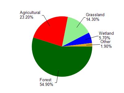
Marinuka Lake is located in the Beaver Creek and Lake Marinuka watershed which is 160.31 mi². Land use in the watershed is primarily forest (54.90%), agricultural (23.20%) and a mix of grassland (14.30%) and other uses (7.60%). This watershed has 375.97 stream miles, 229.76 lake acres and 3,765.47 wetland acres.
Nonpoint Source Characteristics
This watershed is ranked Not Available for runoff impacts on streams, Not Available for runoff impacts on lakes and Medium for runoff impacts on groundwater and therefore has an overall rank of Medium. This value can be used in ranking the watershed or individual waterbodies for grant funding under state and county programs.This water is ranked High Lake for individual Impoundments based on runoff problems and the likelihood of success from project implementation.