Douglas
No
No
Yes
Fish and Aquatic Life
Overview
Faxon Creek, which is also known locally as Central Park Creek, is ‘officially’ an unnamed tributary to Superior Bay (Lake Superior). The entire stream is within the City of Superior, Douglas County. From its mouth at Superior Bay and heading upstream, it flows for about its last 0.4 miles underground, passing under approximately six roads, highways, or RR crossings. Another 0.1 - 0.2 miles is channelized in this section leading upstream into Central Park. In Central Park it starts to have a more “natural” channel, near its confluence with an unnamed 1st order tributary (WBIC: 5000527). Proceeding upstream from Central Park, it passes under Hill Avenue, a RR track system, 21st street, Catlin Avenue and 28th Street. Along the way it passes through YMCA, WITC, Superior Senior High, and UWS campuses/grounds, most of which have very poor buffer zones, with large lawn areas almost down to the creek in areas. In this section a 2nd order, unnamed tributary (WBIC: 5000547) joins Faxon Creek. At this confluence Faxon Creek becomes a 3rd order stream. Directly upstream of 28th Street Faxon Creek has one more 1st order unnamed tributary (WBIC: 5000563). From this confluence downstream Faxon Creek appears to be perennial, even if at very low flows during certain time periods. Upstream of this confluence where it is a 1st order stream, it can be intermittent or dry. Headwater areas as you go further upstream in the watershed towards Tower Avenue (WI Hwy 35), Wal-Mart, and other shopping areas are now home to parking lots and other impervious surface areas where there probably had once been wetlands that provided the original headwater areas. From 28th Street upstream, Faxon Creek appears to be a runoff stream - as opposed to the unnamed tributaries mentioned above which at least partially drain some wetland areas and may contain some groundwater flow also, which appear to keep Faxon Creek perennial in nature from the point where it becomes either a 2nd or 3rd order stream downstream of confluences with tributaries.
Initial evaluation of Faxon Creek for potential inclusion on the 303d list occurred during 2008. Sampling for fish, macroinvertebrates, and qualitative habitat ratings was conducted at three sites: 1) in Central Park, 2) upstream of 21st Street, and 3) downstream of 28th Street. Overall results, or trends, of fish and invertebrate IBI’s appear to support the addition of this stream to the impaired waters list. Biological condition (IBI’s) ranged from very poor to fair primarily (with two exceptions for M-IBI), with most scores/ratings equal to poor or fairly poor. Although several IBI results appear to somewhat contradict each other, professional judgment of the status of Faxon by local biologists is that this stream is impaired for degraded habitat, at least. Professional judgment is this stream could support more diverse fish and macroinvertebrate communities, with more species present that are less tolerant of pollution. Sampling in 2008 did not find any fish species present that were not pollution intolerant (fish species present included creek chub, white sucker, fathead minnow, and brook stickleback), and only seven invertebrate taxa total were collected that are indicators of good water quality.
Results were analyzed using both the Lake Superior Warmwater Fish IBI and also the Small or Intermittent Stream Fish IBI in regards to biotic integrity of the fish community. The most appropriate fish IBI to use will be evaluated further, but presently we reason that poorer results from the Lake Superior Warm-water Fish IBI are most appropriate for evaluation of Faxon Creek for two reasons: First, although Faxon Creek is a small headwater stream and intermittent upstream of 28th Street and unnamed tributary - 5000563, it is a perennial stream below 28th Street, where all three of my sampling stations occurred, and secondly, the connection of this stream as a direct tributary to Lake Superior and evidence of migratory runs of white suckers (as seen in a fairly abundant population of juvenile white suckers) from Lake Superior would seem to support using the Lake Superior Warmwater IBI results. This also supports listing Faxon Creek’s attainable FAL use as a “Warmwater Forage Fishery”.
Since only very limited water chemistry sampling was done, the impairment could not be attributed directly to any one pollutant positively at this time. However, evidence from run-off events (from streets and poorly buffered lawns/grounds) appears to indicate excessive flow during events and litter to be a problem for this stream. HBI results also indicate possible organic pollution based on low scores from sample results: no organisms were present that are completely intolerant of organic pollution, and only several taxa were sampled that were tolerant to only a small degree of organic pollution; invertebrates sampled were dominated by those tolerant of significant organic pollution. Further water chemistry sampling/monitoring could also potentially prove the stream is impaired for excessive sedimentation, suspended solids/turbidity, or other potential impairments or contaminants. At the present time, Faxon Creek has been placed under "High Watch-Water" status until future planned monitoring occurs.
Date 2010
Author Cordell Manz
General Condition
The entire stream is within the City of Superior, Douglas County. From its mouth at Superior Bay (Lake Superior) and heading upstream, it flows its last 0.4 miles underground, passing under approx. 6 roads, highways, or RR crossings. Another 0.1 to 0.2 miles is channelized in this section up into Central Park, where it starts to have a more natural channel here, near its confluence with an unnamed 1st order tributary (WBIC: 5000527). Proceeding upstream from Central Park, it passes under Hill Avenue, a RR track system, 21st street, Catlin Avenue and 28th Street. Along the way it passes through YMCA, WITC, Superior Senior High, and UWS campuses/grounds most of these grounds have very poor buffer zones, with large lawn areas almost down to the creek.
Also, in this stretch a 2nd order unnamed tributary (WBIC: 5000547) joins Faxon Creek. Below the confluence with this unnamed trib, Faxon Creek is a 3rd order stream. Upstream of 28th Street is one more 1st order unnamed tributary (WBIC: 5000563). From this confluence downstream Faxon Creek appears to be perennial, whereas upstream it is a 1st order stream, and soon becomes intermittent as you go further upstream towards Tower Avenue (Hwy 35) and Wal-Mart and other parking lots towards where it probably had its original headwater areas. From 28th Street upstream it appears to be mainly a runoff stream, as opposed to the unnamed tributaries mentioned above which at least partially drain some wetland areas and probably contain some groundwater flow also, to keep Faxon Creek perennial in nature from the point it becomes 2nd order and below. I am also recommending that the three unnamed tributaries listed above be added to the 303d list as well, to encompass this whole stream system (with listing for the same reasons, etc).
Date 2009
Author Cordell Manz
Impaired Waters
Faxon (Central Park) Creek was recently evaluated during the ten-year period of 2009 through 2018 for results that were reported to the USEPA for the 2020 Clean Water Act condition report. The waterbody is considered impaired, or in poor condition for designated uses which include the quality of fish and aquatic life, recreational use, and public health and welfare (fish consumption and related). Pollutants or problems encountered during sampling (impairments) are determined based on water quality standards outlined in Wisconsin 2020 Consolidated Assessment and Listing Methodology (WisCALM). Assessment results show water conditions that are potentially harmful for Recreation use due to values for E. coli that fall into the range expected for an aquatic community in poor health, therefore this water is listed as impaired. This water was previously listed in 2014 for degraded biological community.
Assessment results during the 2020 listing cycle show impairment by E. coli levels that exceed 2020 WisCALM criteria for Recreation use. Based on the most updated information, E. coli was proposed as an additional pollutant to this already impaired water in 2020.
Date 2019
Author Ashley Beranek
Condition
Wisconsin has over 84,000 miles of streams, 15,000 lakes and milllions of acres of wetlands. Assessing the condition of this vast amount of water is challenging. The state's water monitoring program uses a media-based, cross-program approach to analyze water condition. An updated monitoring strategy (2015-2020) is now available. Compliance with Clean Water Act fishable, swimmable standards are located in the Executive Summary of Water Condition in 2018. See also the 'monitoring and projects' tab.
Reports
Recommendations
Monitor Aquatic Biology
Continued biological sampling of Faxon Creek and unnamed tributaries should be a priority to verify condition/status. Also, monitoring for pollutants/contaminants should be performed, including sampling for turbidity, TSS, nutrients (phosphorus) and sediment contamination (PAH's and metals).
Recommendations
Recommendations: Continued biological sampling of Faxon Creek and unnamed tributaries should be a priority to verify condition/status. Also, monitoring for pollutants/contaminants should be performed, including sampling for turbidity, TSS, nutrients (phosphorus) and sediment contamination (PAH's and metals). This work is planned in 2010, depending on potential project funding.
Date 2010
Author Cordell Manz
Management Goals
Wisconsin's Water Quality Standards provide qualitative and quantitative goals for waters that are protective of Fishable, Swimmable conditions [Learn more]. Waters that do not meet water quality standards are considered impaired and restoration actions are planned and carried out until the water is once again fishable and swimmable
Management goals can include creation or implementation of a Total Maximum Daily Load analysis, a Nine Key Element Plan, or other restoration work, education and outreach and more. If specific recommendations exist for this water, they will be displayed below online.
Monitoring
Monitoring the condition of a river, stream, or lake includes gathering physical, chemical, biological, and habitat data. Comprehensive studies often gather all these parameters in great detail, while lighter assessment events will involve sampling physical, chemical and biological data such as macroinvertebrates. Aquatic macroinvertebrates and fish communities integrate watershed or catchment condition, providing great insight into overall ecosystem health. Chemical and habitat parameters tell researchers more about human induced problems including contaminated runoff, point source dischargers, or habitat issues that foster or limit the potential of aquatic communities to thrive in a given area. Wisconsin's Water Monitoring Strategy was recenty updated.
Grants and Management Projects
Monitoring Projects
| WBIC | Official Waterbody Name | Station ID | Station Name | Earliest Fieldwork Date | Latest Fieldwork Date | View Station | View Data |
|---|
| 2843700 | Unnamed | 10029825 | Central Park (Faxon) Creek above 21st St. | 10/31/2008 | 1/1/2015 | Map | Data |
| 2843700 | Unnamed | 10037077 | NEMADJI RIVER - AT 31ST STREET | 7/11/1992 | 7/11/1992 | Map | Data |
| 5500285 | Unnamed | 10048628 | Unnamed Tributary to Faxon Creek, 5M upstream of confluence w/Faxon Creek | 6/14/2017 | 9/7/2017 | Map | Data |
| 2843700 | Unnamed | 163288 | Bear Creek - Cr-2 /Upstream Of 28th Street | 6/16/1993 | 7/11/1994 | Map | Data |
| 2843700 | Unnamed | 10052012 | Unnamed (Faxon Creek; 2843700) at Hill and Laurel Ave | 8/6/2019 | 10/27/2025 | Map | Data |
| 2843700 | Unnamed | 10031583 | Central Park (Faxon) Creek at Marina Dr/Osagi Trail | 8/5/2010 | 8/28/2014 | Map | Data |
| 2843700 | Unnamed | 10047268 | Faxon Creek @ Central Park | 8/8/2016 | 5/7/2021 | Map | Data |
| 2843700 | Unnamed | 163364 | Central Park Creek - Fp Cr-3 | 7/11/1994 | 7/11/1994 | Map | Data |
| 2843700 | Unnamed | 10029826 | Central Park (Faxon) Creek at Central Park | 10/31/2008 | 10/13/2025 | Map | Data |
| 2843700 | Unnamed | 10052005 | Unnamed (2843700) S of N 28th Street | 7/12/2021 | 10/5/2023 | Map | Data |
| 2843700 | Unnamed | 10029824 | Central Park (Faxon) Creek DS 28th St. | 10/31/2008 | 11/6/2020 | Map | Data |
| 5500284 | Unnamed | 10047268 | Faxon Creek @ Central Park | 8/8/2016 | 5/7/2021 | Map | Data |
| 2843700 | Unnamed | 10048629 | Faxon Creek 40M Upstream of Catlin Ave. | 6/14/2017 | 9/7/2017 | Map | Data |
|
Watershed Characteristics
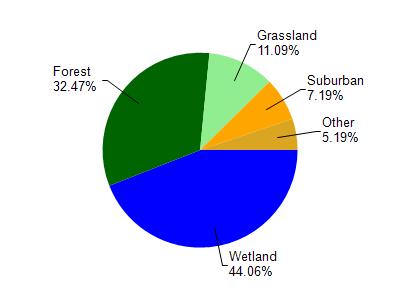
Unnamed is located in the St. Louis and Lower Nemadji River watershed which is 159.67 mi². Land use in the watershed is primarily wetland (44.10%), forest (32.50%) and a mix of grassland (11.10%) and other uses (12.40%). This watershed has 432.66 stream miles, 8,490.75 lake acres and 26,945.85 wetland acres.
Nonpoint Source Characteristics
This watershed is ranked Not Ranked for runoff impacts on streams, Not Available for runoff impacts on lakes and Low for runoff impacts on groundwater and therefore has an overall rank of Low. This value can be used in ranking the watershed or individual waterbodies for grant funding under state and county programs.This water is ranked High Stream for individual Rivers based on runoff problems and the likelihood of success from project implementation.