Barron
No
Yes
Yes
Fish and Aquatic Life
Overview
Silver Lake is a 337-acre seepage lake about five miles northeast of Cumberland. This lake was selected in 1986 as a Long-Term Trend Monitoring lake. Intensive water quality monitoring since that time has revealed that Silver Lake has exceptional water quality with Trophlc State Index values of about 42. This hgh quality aquatic resource has also been classified as an outstanding resource water under the provisions of Chapter NR 102.10 of the Wis. Adm. Code. A volunteer has been collecting water clarity data under the self-help lake monitoring program. The residents around Silver Lake have organized a lake association. This lake does experience fluctuations in water level of several feet in response to the long-term variations in the precipitation and groundwater cycles. Fish tissue analysis for mercury has been conducted, resulting in a fish consumption advisory for walleye 15 to 26 inches long (Categories 2 and 3). This hgh quality lake is susceptible to any increase in phosphorus loading and is a high priority for protection management.
Date 1996
Author Aquatic Biologist
Historical Description
Source: 1964, Surface Water Resources of Barron County Silver Lake T36N, R13W, Sections 24, 25
A soft water seepage lake, landlocked and having a fish population of northern pike, walleyes, largemouth bass, perch, bluegills, black crappies, rock bass, bullheads, whitefish and white suckers. It is managed as a two-story trout lake and has rainbows present. The lakeshore vegetation consists mainly of upland hardwoods and open farmland with a few scattered white pine. It is accessible at the south end of the lake by county access. Plans are being made for developing a park with swimming facilities here. Total public frontage amounts to 0. 18 miles. Private development consists of 25 cottages and homes.
Surface Acres = 338.5, S.D.F. = 2.25, Maximum Depth = 78 feet
Date 1964
Author Surface Water Inventory Of Wisconsin
Impaired Waters
Silver Lake (1881100) was placed on the impaired waters list for Mercury in fish tissue in 1998. This water was assessed during the 2016 listing cycle; total phosphorus and chlorophyll sample data were clearly below 2016 WisCALM listing thresholds for the Recreation use and Fish and Aquatic Life use. This lake is considered impaired for Fish Consumption use and meeting REC and FAL uses.
Date 2015
Author Aaron Larson
Condition
Wisconsin has over 84,000 miles of streams, 15,000 lakes and milllions of acres of wetlands. Assessing the condition of this vast amount of water is challenging. The state's water monitoring program uses a media-based, cross-program approach to analyze water condition. An updated monitoring strategy (2015-2020) is now available. Compliance with Clean Water Act fishable, swimmable standards are located in the Executive Summary of Water Condition in 2018. See also the 'monitoring and projects' tab.
Reports
Recommendations
Protect Riparian or Shorelands
Silver Lake Association is sponsoring a project to implement shoreline stabilization, restoration, runoff reduction, and wetland restoration practices. Project tasks: 1) Design/stabilization on approximately 10 shoreline sites; 2) Shoreline restoration design technical assistance; 3) Design/installation on approximately 6 runoff reduction sites; 4) Install woody habitat improvement (Fish Sticks) on approximately 4 sites; 5) Design/implement wetland restoration; 6) Landscaper training/education.
Diagnostic/Feasibility Assessment
The Barron County Soil & Water Conservation Department, in cooperation with the US Geological Survey, Dept. of Nat. Res., and a private consultant, will conduct a comprehensive diagnostic/feasibility study of Silver Lake and it's watershed and develop a lake management plan.
Management Goals
Wisconsin's Water Quality Standards provide qualitative and quantitative goals for waters that are protective of Fishable, Swimmable conditions [Learn more]. Waters that do not meet water quality standards are considered impaired and restoration actions are planned and carried out until the water is once again fishable and swimmable
Management goals can include creation or implementation of a Total Maximum Daily Load analysis, a Nine Key Element Plan, or other restoration work, education and outreach and more. If specific recommendations exist for this water, they will be displayed below online.
Monitoring
Monitoring the condition of a river, stream, or lake includes gathering physical, chemical, biological, and habitat data. Comprehensive studies often gather all these parameters in great detail, while lighter assessment events will involve sampling physical, chemical and biological data such as macroinvertebrates. Aquatic macroinvertebrates and fish communities integrate watershed or catchment condition, providing great insight into overall ecosystem health. Chemical and habitat parameters tell researchers more about human induced problems including contaminated runoff, point source dischargers, or habitat issues that foster or limit the potential of aquatic communities to thrive in a given area. Wisconsin's Water Monitoring Strategy was recenty updated.
Grants and Management Projects
Monitoring Projects
| WBIC | Official Waterbody Name | Station ID | Station Name | Earliest Fieldwork Date | Latest Fieldwork Date | View Station | View Data |
|---|
| 1881100 | Silver Lake | 10018510 | Silver Lake -- Access at SW End Of Lake | 9/19/2003 | 9/8/2025 | Map | Data |
| 1881100 | Silver Lake | 10034900 | Silver Lake Beach | 6/16/2005 | 9/5/2006 | Map | Data |
| 1881100 | Silver Lake | 10039846 | Silver Lake Northeast Bay near Cumberland WI (USGS) | 6/16/2005 | 6/6/2006 | Map | Data |
| 1881100 | Silver Lake | 10041261 | Silver Lake nearshore south central site (Site #3) | 5/17/2005 | 5/17/2005 | Map | Data |
| 1881100 | Silver Lake | 10041259 | Silver Lake nearshore site south (Site #1) | 5/17/2005 | 5/17/2005 | Map | Data |
| 1881100 | Silver Lake | 10041266 | Silver Lake northeast site (Site #15) | 5/17/2005 | 5/17/2005 | Map | Data |
| 1881100 | Silver Lake | 033100 | Silver Lake - Deep Hole | 5/23/1987 | 6/21/2026 | Map | Data |
| 1881100 | Silver Lake | 10041264 | Silver Lake bank sample west (Site #7) | 5/17/2005 | 5/17/2005 | Map | Data |
| 1881100 | Silver Lake | 10041268 | Silver Lake bank site east (Site #24) | 5/17/2005 | 5/17/2005 | Map | Data |
| 1881100 | Silver Lake | 10041260 | Silver Lake bank sample south shore (Site #1) | 5/17/2005 | 5/17/2005 | Map | Data |
| 1881100 | Silver Lake | 10041265 | Silver Lake northwest site (Site #13) | 5/17/2005 | 5/18/2005 | Map | Data |
| 1881100 | Silver Lake | 10041267 | Silver Lake east nearshore site (Site #21) | 5/17/2005 | 5/17/2005 | Map | Data |
| 5004997 | Unnamed | 033214 | Unnamed Creek - Inlet To Silver Lake-11th St | | | Map | Data |
| 1881100 | Silver Lake | 10000656 | Silver Lake | 9/5/2000 | 8/19/2025 | Map | Data |
| 1881100 | Silver Lake | 10041262 | Silver Lake bank site south central (Site #3) | 5/17/2005 | 5/17/2005 | Map | Data |
| 5004997 | Unnamed | 10039848 | Silver Lake Tributary No 7 near Cumberland WI | 3/30/2005 | 10/17/2006 | Map | Data |
| 1881100 | Silver Lake | 10041263 | Silver Lake nearshore site west (Site #7) | 5/17/2005 | 5/17/2005 | Map | Data |
|
Watershed Characteristics
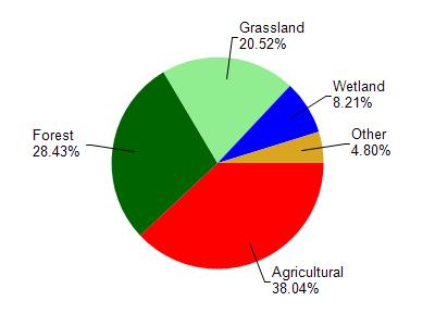
Silver Lake is located in the Yellow River watershed which is 239.35 mi². Land use in the watershed is primarily agricultural (38%), forest (28.40%) and a mix of grassland (20.50%) and other uses (13.00%). This watershed has 415.31 stream miles, 2,929.80 lake acres and 11,565.29 wetland acres.
Nonpoint Source Characteristics
This watershed is ranked High for runoff impacts on streams, Not Available for runoff impacts on lakes and High for runoff impacts on groundwater and therefore has an overall rank of High. This value can be used in ranking the watershed or individual waterbodies for grant funding under state and county programs.However, all waters are affected by diffuse pollutant sources regardless of initial water quality. Applications for specific runoff projects under state or county grant programs may be pursued. For more information, go to surface water program grants.