Burnett
No
No
Yes
Fish and Aquatic Life
Overview
For years (prior to the 1960s), the Yellow River carried untreated city wastewater, creamery waste and whey downstream to Yellow Lake (probably about 30 miles away). After the point source was removed, the lake has steadily improved, but is still impaired likely from this very heavy, historical, point source loading. DNR staff in the area are not aware of other natural or high-background sources, and there shouldn't be significant agricultural contributions in this area.
Recommended for listing for impaired Recreational Uses, but not for Fish & Aquatic Life. Per Kris Larsen, Northern Region Fisheries Technician, Yellow Lake is vastly improved from the historical situation, but still warrants listing on the federal 303(d) list due to blue green algae blooms that restrict swimming. Prior to the 1960s, the Yellow River carried untreated city wastewater, creamery waste and whey downstream to Yellow Lake (~30 miles away). The lake had so many plants and algae around the 1960s, that trees seedlings could grow on the algal crust. After the point source was removed, the lake has steadily improved, but still has enough algae in the hot summer months that people do not swim. Blue green algae blooms are frequent and macrophyte growth is high. Currently, Yellow Lake s TSI-chlorophyll score of 62 puts this lake in the Fair category for a shallow lowland lake, but its average Total Phosphorus concentration (2004-2008) is .048 mg/l, which exceeds the listing threshold for Shallow Lowland lakes of greater than or equal to 0.04 mg/l. Yellow Lake is, however, meeting its Fish and Aquatic Life Use with an excellent and very diverse fishery, according to Larry Damman, Northern Region Fisheries Biologist. It has one of the state s best, sustainable sturgeon populations (including a world record), cisco spawning, a naturally reproducing walleye population (which is rare), and large northern pike and muskies. DNR staff are not aware of natural or high-background sources, and there shouldn't be significant agricultural contributions in this area. The impairment is likely from very heavy, historical, point source loading.
Date 2009
Author Aquatic Biologist
Historical Description
Yellow Lake is a 2872 acre drainage lake located on the Yellow River. This lake exhibits some
eutrophic symptoms but has an excellent fishery, including trophy lake sturgeon and a cisco
population. A long range lake management plan would be desireable to assist this lake
community in coping with the sometimes troublesome algae and macrophyte accumulations and
preserving the critical natural resource areas.
Date 1992
Author Surface Water Inventory Of Wisconsin
Impaired Waters
Yellow Lake (WBIC 2675200) was placed on the impaired waters list for total phosphorus in 2010. The 2018 assessments showed continued impairment by phosphorus; total phosphorus and chlorophyll-a sample data exceeded the 2018 WisCALM listing thresholds for the Recreation use and Fish and Aquatic Life use. Based on the most updated information, no change in the existing impaired waters listing was needed.
Date 2017
Author Ashley Beranek
Impaired Waters
Yellow Lake (2675200) was placed on the impaired waters list for total phosphorus in 2010. The 2016 assessments showed continued impairment by phosphorus; total phosphorus sample data overwhelmingly exceeded 2016 WisCALM listing thresholds for the Recreation use and Fish and Aquatic Life use, and chlorophyll data overwhelmingly exceeded FAL thresholds and exceeded REC thresholds. Based on the most updated information, no change in existing impaired waters listing is needed.
Date 2015
Author Aaron Larson
Condition
Wisconsin has over 84,000 miles of streams, 15,000 lakes and milllions of acres of wetlands. Assessing the condition of this vast amount of water is challenging. The state's water monitoring program uses a media-based, cross-program approach to analyze water condition. An updated monitoring strategy (2015-2020) is now available. Compliance with Clean Water Act fishable, swimmable standards are located in the Executive Summary of Water Condition in 2018. See also the 'monitoring and projects' tab.
Reports
Recommendations
Management Goals
Wisconsin's Water Quality Standards provide qualitative and quantitative goals for waters that are protective of Fishable, Swimmable conditions [Learn more]. Waters that do not meet water quality standards are considered impaired and restoration actions are planned and carried out until the water is once again fishable and swimmable
Management goals can include creation or implementation of a Total Maximum Daily Load analysis, a Nine Key Element Plan, or other restoration work, education and outreach and more. If specific recommendations exist for this water, they will be displayed below online.
Monitoring
Monitoring the condition of a river, stream, or lake includes gathering physical, chemical, biological, and habitat data. Comprehensive studies often gather all these parameters in great detail, while lighter assessment events will involve sampling physical, chemical and biological data such as macroinvertebrates. Aquatic macroinvertebrates and fish communities integrate watershed or catchment condition, providing great insight into overall ecosystem health. Chemical and habitat parameters tell researchers more about human induced problems including contaminated runoff, point source dischargers, or habitat issues that foster or limit the potential of aquatic communities to thrive in a given area. Wisconsin's Water Monitoring Strategy was recenty updated.
Grants and Management Projects
Monitoring Projects
| WBIC | Official Waterbody Name | Station ID | Station Name | Earliest Fieldwork Date | Latest Fieldwork Date | View Station | View Data |
|---|
| 2675200 | Yellow Lake | 10001044 | Yellow Lake | 9/5/2000 | 9/12/2017 | Map | Data |
| 2675200 | Yellow Lake | 10034905 | Yellow Lake at outlet near Webster (USGS) | | | Map | Data |
| 2675200 | Yellow Lake | 073079 | Yellow Lake - Site A Near Center | 7/27/1992 | 8/29/2025 | Map | Data |
| 2675200 | Yellow Lake | 10018196 | Yellow Lake -- Lodge Access / Off Yellow Lake Rd | 7/14/2007 | 11/17/2025 | Map | Data |
| 2675200 | Yellow Lake | 073066 | Yellow Lake - NE Part Of Lake - Site B | 7/27/1992 | 7/18/2011 | Map | Data |
| 2675200 | Yellow Lake | 10018120 | Yellow Lake -- Ike Walton Access / Lake Ave | 9/25/2003 | 11/17/2025 | Map | Data |
| 2675200 | Yellow Lake | 10018119 | Yellow Lake -- Jeffries Road Access | 8/26/2006 | 11/17/2025 | Map | Data |
|
Watershed Characteristics
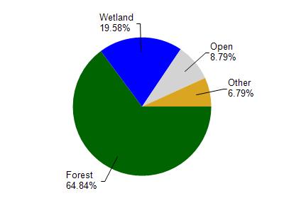
Yellow Lake is located in the Lower Yellow (Burnett Co.) River watershed which is 208.95 mi². Land use in the watershed is primarily forest (64.90%), wetland (19.60%) and a mix of open (8.80%) and other uses (6.80%). This watershed has 99.73 stream miles, 13,740.17 lake acres and 23,442.16 wetland acres.
Nonpoint Source Characteristics
This watershed is ranked Not Ranked for runoff impacts on streams, Not Ranked for runoff impacts on lakes and Low for runoff impacts on groundwater and therefore has an overall rank of Low. This value can be used in ranking the watershed or individual waterbodies for grant funding under state and county programs.This water is ranked High Lake for individual Lakes based on runoff problems and the likelihood of success from project implementation.