Bayfield
No
No
No
Fish and Aquatic Life
Overview
Lost Creeks Numbers 1, 2 and 3
These three streams empty into sloughs that drain into Lake Superior's Siskiwit Bay. Lost Creek No. 1 just south of Cornucopia near County Highway C, is a small, spring-fed stream considered a Class II brook trout stream that also supports migratory runs. It is shallow, sandy and has little in-stream cover.
During survey work conducted as part of the coastal wetlands evaluation, one rare species of macroinvertebrate was found in Lost Creek No. 1 and overall taxa richness was moderate (5-24 species) (Epstein 1997). The survey noted that low flows have a significant impact on in-stream habitat quality and some bank erosion.
Lost Creek No. 2 is similar to Lost Creek No. 1. It, too, is a Class II brook trout water. During the coastal wetlands evaluation, no rare species of macroinvertebrate were found in Lost Creek No. 2 and overall taxa richness was moderate (5-24 species) (Epstein 1997). The survey noted that significant silt and streambank erosion affected in-stream habitat quality.
Unlike Nos. 1 and 2, Lost Creek No. 3 is a warm water drainage stream subject to wide fluctuations in water levels and turbid water conditions are common. The creek supports only minnows. During the coastal wetlands evaluation, one rare species of macroinvertebrate was found in Lost Creek No. 3 and overall taxa richness was moderate (5-24 species) (Epstein 1997). The survey noted some turbidity.
The three streams join at the Lost Creek Natural Area at the western end of Siskiwit Bay. This is an extensive coastal wetland that provides habitat for unique plants, shorebirds and fish. The estuary and surrounding wetlands of the three creeks provide important habitat for lake cress, a plant considered endangered in Wisconsin. The estuary provides spawning habitat for northern pike and supports several species of forage fish. The lower reaches of these three creeks are in a combination of state and private ownership. There has been development along the Siskiwit Bay shoreline that shelters the wetland. The Lake Superior Binational Program identified this area as important to the integrity of the Lake Superior ecosystem for coastal wetlands, fish and wildlife spawning and nursery grounds and threatened or endangered species habitat. The coastal wetlands evaluation identified this area as priority wetlands (see Lost Creek Wetlands discussion, above).
From: Turville-Heitz, Meg. 1999. Lake Superior Basin Water Quality Management Plan. Wisconsin Department of Natural Resources, Madison, WI.
Date 1999
Author Aquatic Biologist
Condition
Wisconsin has over 84,000 miles of streams, 15,000 lakes and milllions of acres of wetlands. Assessing the condition of this vast amount of water is challenging. The state's water monitoring program uses a media-based, cross-program approach to analyze water condition. An updated monitoring strategy (2015-2020) is now available. Compliance with Clean Water Act fishable, swimmable standards are located in the Executive Summary of Water Condition in 2018. See also the 'monitoring and projects' tab.
Reports
Management Goals
Wisconsin's Water Quality Standards provide qualitative and quantitative goals for waters that are protective of Fishable, Swimmable conditions [Learn more]. Waters that do not meet water quality standards are considered impaired and restoration actions are planned and carried out until the water is once again fishable and swimmable
Management goals can include creation or implementation of a Total Maximum Daily Load analysis, a Nine Key Element Plan, or other restoration work, education and outreach and more. If specific recommendations exist for this water, they will be displayed below online.
Monitoring
Monitoring the condition of a river, stream, or lake includes gathering physical, chemical, biological, and habitat data. Comprehensive studies often gather all these parameters in great detail, while lighter assessment events will involve sampling physical, chemical and biological data such as macroinvertebrates. Aquatic macroinvertebrates and fish communities integrate watershed or catchment condition, providing great insight into overall ecosystem health. Chemical and habitat parameters tell researchers more about human induced problems including contaminated runoff, point source dischargers, or habitat issues that foster or limit the potential of aquatic communities to thrive in a given area. Wisconsin's Water Monitoring Strategy was recenty updated.
Grants and Management Projects
| Project Name (Click for Details) | Year Started |
|---|
|
|
Monitoring Projects
| WBIC | Official Waterbody Name | Station ID | Station Name | Earliest Fieldwork Date | Latest Fieldwork Date | View Station | View Data |
|---|
|
|
Watershed Characteristics
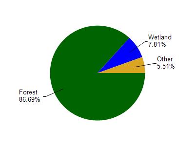
Lost Creek # 3 is located in the Bayfield Peninsula Northwest watershed which is 236.05 mi². Land use in the watershed is primarily forest (86.60%), wetland (7.80%) and a mix of grassland (4.60%) and other uses (0.90%). This watershed has 473.06 stream miles, 43,216.55 lake acres and 6,677.27 wetland acres.
Nonpoint Source Characteristics
This watershed is ranked Not Ranked for runoff impacts on streams, Not Available for runoff impacts on lakes and Low for runoff impacts on groundwater and therefore has an overall rank of Low. This value can be used in ranking the watershed or individual waterbodies for grant funding under state and county programs.However, all waters are affected by diffuse pollutant sources regardless of initial water quality. Applications for specific runoff projects under state or county grant programs may be pursued. For more information, go to surface water program grants.