Bayfield
No
No
No
Fish and Aquatic Life
Overview
Based on site photographs taken in June, 1995, this stream appears to sustain significant year-round flow. At one time, the lower reaches of the stream were stained a deep red from waste generated by E.I. du Pont de Nemours Company, a producer of military explosives. The waste included acid washings, sellite wastes or Ared waters,@ and cooling waters. The plant operated from 1904 to 1971. At the time of plant closure, no aquatic life existed in the stream. Since the Barksdale works discharge to this stream predated any environmental regulation or monitoring in the state, it is unclear what role this stream could serve in the Lake Superior ecosystem. Fisheries management surveys in the 1980s found brook trout and coho salmon in the stream; brown and rainbow trout could potentially be present (Pratt 1996). Similar streams to the north and south support
Concerns raised by a citizen in 1980 led to WDNR investigating a complaint of unvegetated areas, the presence of yellow material on the ground, drums and canisters sitting in areas of oily, standing water and a yellowish-orange effluent in a drainage pipe that ultimately emptied into Boyd Creek (Nehls-Lowe 1995). WDNR collected seven surface soil samples, four surface water samples and two groundwater samples. Groundwater was reviewed for pH and inorganic constituents only, not for organic compounds or the residues of explosives. Two surface soil samples had elevated levels of explosive residues and two others were acidic. Two of the surface water samples taken from the drainage ditch had elevated levels of sulfates and a pH between 3.5 and 4.3; Boyd Creek sediments were not sampled. WDNR recommended that the company neutralize areas found to be acidic, remove the drainage pipe and acidic effluent, remove waste materials and empty drums disposed of along Boyd Creek, and conduct further sampling at areas found to have elevated residues. In a letter from du Pont dated August 4, 1983, the company said it had neutralized the nitric acid area and seeded it; removed the culvert pipe east of the nitric acid production area; regraded the ditch to form a swale, neutralized it and seeded it; removed the empty barrels from the edge of the creek, crushed them and buried them east of the old barrel dump and regraded and seeded the bank; removed barrels from within Boyd Creek, crushed and deposited them in a barrel landfill on site and capped them with one foot of clay; collected three soil samples to find no contamination and sealed two drinking water wells..
These substances do not substantially bioaccumulate in the tissues of plants or animals. It is unclear whether any residual contamination might affect wild or raised animals on the site or on people who eat them (Parkinson, 2/14/96). A site visit shows remnants of overhead piping used for acids. The piping was at one time run underground, but it isn't clear if this piping was removed and the soils examined (Parkinson 3/27/96).
The site is under review by the WDNR's contaminated sediment management team. Contact with du Pont to request additional information groundwater, soils, and sediment is under way; data will be reviewed to determine if further assessment is necessary, likely sometime in 1999 (Liebenstein).
From: Turville-Heitz, Meg. 1999. Lake Superior Basin Water Quality Management Plan. Wisconsin Department of Natural Resources, Madison, WI.
Date 1999
Author Aquatic Biologist
Condition
Wisconsin has over 84,000 miles of streams, 15,000 lakes and milllions of acres of wetlands. Assessing the condition of this vast amount of water is challenging. The state's water monitoring program uses a media-based, cross-program approach to analyze water condition. An updated monitoring strategy (2015-2020) is now available. Compliance with Clean Water Act fishable, swimmable standards are located in the Executive Summary of Water Condition in 2018. See also the 'monitoring and projects' tab.
Reports
Management Goals
Wisconsin's Water Quality Standards provide qualitative and quantitative goals for waters that are protective of Fishable, Swimmable conditions [Learn more]. Waters that do not meet water quality standards are considered impaired and restoration actions are planned and carried out until the water is once again fishable and swimmable
Management goals can include creation or implementation of a Total Maximum Daily Load analysis, a Nine Key Element Plan, or other restoration work, education and outreach and more. If specific recommendations exist for this water, they will be displayed below online.
Monitoring
Monitoring the condition of a river, stream, or lake includes gathering physical, chemical, biological, and habitat data. Comprehensive studies often gather all these parameters in great detail, while lighter assessment events will involve sampling physical, chemical and biological data such as macroinvertebrates. Aquatic macroinvertebrates and fish communities integrate watershed or catchment condition, providing great insight into overall ecosystem health. Chemical and habitat parameters tell researchers more about human induced problems including contaminated runoff, point source dischargers, or habitat issues that foster or limit the potential of aquatic communities to thrive in a given area. Wisconsin's Water Monitoring Strategy was recenty updated.
Grants and Management Projects
| Project Name (Click for Details) | Year Started |
|---|
|
|
Monitoring Projects
| WBIC | Official Waterbody Name | Station ID | Station Name | Earliest Fieldwork Date | Latest Fieldwork Date | View Station | View Data |
|---|
| 2887000 | Boyd Creek | 043021 | Boyd Creek at Sth 13 | 6/12/1997 | 8/5/2023 | Map | Data |
| 2887000 | Boyd Creek | 10013500 | Boyd Creek- 180 Meters Downstream Hwy 13- Station #1 | | | Map | Data |
| 2887000 | Boyd Creek | 10032643 | Boyd Creek at Ondossagon Rd. | 7/15/2018 | 7/15/2018 | Map | Data |
|
Watershed Characteristics
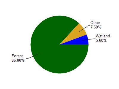
Boyd Creek is located in the Bayfield Peninsula Southeast watershed which is 301.48 mi². Land use in the watershed is primarily forest (86.80%), wetland (5.60%) and a mix of grassland (4.10%) and other uses (3.50%). This watershed has 453.79 stream miles, 291,749.17 lake acres and 6,560.31 wetland acres.
Nonpoint Source Characteristics
This watershed is ranked Not Ranked for runoff impacts on streams, Not Available for runoff impacts on lakes and Low for runoff impacts on groundwater and therefore has an overall rank of Low. This value can be used in ranking the watershed or individual waterbodies for grant funding under state and county programs.However, all waters are affected by diffuse pollutant sources regardless of initial water quality. Applications for specific runoff projects under state or county grant programs may be pursued. For more information, go to surface water program grants.