Rock
No
No
No
Fish and Aquatic Life
Overview
Clear Lake is a small seepage and spring-fed lake that has some cottage development and a campground using septic systems. Water quality is considered good, with the fishery dominated by sunfish. A major algae bloom occurred in 1985 but the sources of the problem were not determined. WDNR recently acquired more than 80 acres of land and 800 feet of frontage on the lake and has installed a boat landing.
Date 2002
Author Aquatic Biologist
Historical Description
Source: 1970, Surface Water Resources of Rock County Clear Lake, T4N, R13E, Section 20, Surface Acres = 82, S.D.F. = 1.26, Maximum Depth = 20 feet.
A moderately hard, spring and seepage fed natural lake. The fish population consists of northern pike, largemouth bass, bluegills, black crappies, pumpkinseeds, bullheads and forage species. Slow growing panfish, winterkill and vegetation are occasional management problems. A portion of the shoreline was chemically treated for aquatic vegetation in 1965. Shoreline improvements include 25 cottages, 3 resorts with rental boats, and 1 private campground. There is no public access at the present time. Migrating waterfowl utilize the lake and a few broods of wood duck and blue-wing teal have been observed. Hunting is allowed with no restrictions other than distances from home.
Date 1970
Author Surface Water Inventory Of Wisconsin
General Condition
Clear Lake Blackhawk Drive Pier Beach was assessed for the 2018 listing cycle; E. coli data sample data were clearly below the 2018 WisCALM listing thresholds for the Recreation use. This beach was meeting this designated use and was not considered impaired.
Date 2017
Author Ashley Beranek
Impaired Waters
Clear Lake (WBIC 775000) was placed on the impaired waters list for total phosphorus in 2014. The 2018 assessment showed continued impairment by phosphorus; new total phosphorus and chlorophyll-a sample data exceeded the 2018 WisCALM listing thresholds for the Recreation use and Fish and Aquatic Life use. Based on the most updated information, no change in the existing impaired waters listing was needed.
Date 2017
Author Ashley Beranek
Impaired Waters
Clear Lake (775000) was placed on the impaired waters list for total phosphorus in 2014. The 2016 assessments showed continued excess algal growth; chlorophyll sample data exceed 2016 WisCALM listing thresholds for the Recreation use, however, total phosphorus did not exceed REC thresholds. Total phosphorus and chlorophyll data did not exceed Fish and Aquatic Life listing thresholds. Based on the most updated information, no change in existing impaired waters listing is needed.
Date 2015
Author Aaron Larson
Condition
Wisconsin has over 84,000 miles of streams, 15,000 lakes and milllions of acres of wetlands. Assessing the condition of this vast amount of water is challenging. The state's water monitoring program uses a media-based, cross-program approach to analyze water condition. An updated monitoring strategy (2015-2020) is now available. Compliance with Clean Water Act fishable, swimmable standards are located in the Executive Summary of Water Condition in 2018. See also the 'monitoring and projects' tab.
Reports
Recommendations
Management Goals
Wisconsin's Water Quality Standards provide qualitative and quantitative goals for waters that are protective of Fishable, Swimmable conditions [Learn more]. Waters that do not meet water quality standards are considered impaired and restoration actions are planned and carried out until the water is once again fishable and swimmable
Management goals can include creation or implementation of a Total Maximum Daily Load analysis, a Nine Key Element Plan, or other restoration work, education and outreach and more. If specific recommendations exist for this water, they will be displayed below online.
Monitoring
Monitoring the condition of a river, stream, or lake includes gathering physical, chemical, biological, and habitat data. Comprehensive studies often gather all these parameters in great detail, while lighter assessment events will involve sampling physical, chemical and biological data such as macroinvertebrates. Aquatic macroinvertebrates and fish communities integrate watershed or catchment condition, providing great insight into overall ecosystem health. Chemical and habitat parameters tell researchers more about human induced problems including contaminated runoff, point source dischargers, or habitat issues that foster or limit the potential of aquatic communities to thrive in a given area. Wisconsin's Water Monitoring Strategy was recenty updated.
Grants and Management Projects
Monitoring Projects
| WBIC | Official Waterbody Name | Station ID | Station Name | Earliest Fieldwork Date | Latest Fieldwork Date | View Station | View Data |
|---|
| 775000 | Clear Lake | 10005283 | Clear Lake (Rock County) | 6/3/1994 | 6/21/2024 | Map | Data |
| 775000 | Clear Lake | 543285 | Clear Lake at Beach | 5/11/2004 | 7/20/2026 | Map | Data |
| 775000 | Clear Lake | 10017437 | Clear Lake -- Access at E Blackhawk Dr | 5/19/2006 | 5/30/2009 | Map | Data |
|
Watershed Characteristics
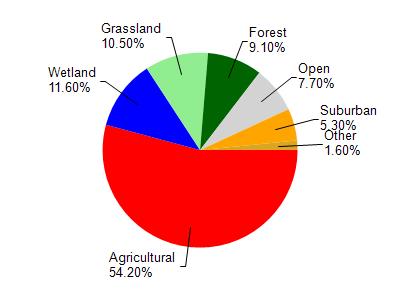
Clear Lake is located in the Lower Koshkonong Creek watershed which is 265.61 mi². Land use in the watershed is primarily agricultural (54.20%), wetland (11.60%) and a mix of grassland (10.50%) and other uses (23.70%). This watershed has 283.47 stream miles, 1,735.65 lake acres and 18,171.94 wetland acres.
Nonpoint Source Characteristics
This watershed is ranked High for runoff impacts on streams, Medium for runoff impacts on lakes and High for runoff impacts on groundwater and therefore has an overall rank of High. This value can be used in ranking the watershed or individual waterbodies for grant funding under state and county programs.However, all waters are affected by diffuse pollutant sources regardless of initial water quality. Applications for specific runoff projects under state or county grant programs may be pursued. For more information, go to surface water program grants.