Sauk
No
No
No
Fish and Aquatic Life
Overview
Mirror Lake
Mirror Lake is a 137-acre impoundment of Dell Creek above Lake Delton. Mirror Lake
consists of two bodies of water, sometimes considered Upper Mirror Lake and Lower Mirror
Lake. These two bodies of water are separated by a one-mile stretch of Dell Creek. Public
ownership of part of the shoreline and public access to the lake is provided by Mirror Lake
State Park, which surrounds the perimeter of the lake. The fishery of the lake includes
bluegill, walleyes, largemouth bass, northern pike and other panfish.
The lake is eutrophic and has relatively poor water quality, which is common to eutrophic
lakes and impoundments. Self-help monitoring on the lake indicates the lake to have generally
poor water clarity conditions. Sedimentation, particularly in the upper end of the lake is a
problem. It is thought that this sedimentation may be part of the reason for the decline of the
wild rice bed in the lake. In addition, nuisance growth of aquatic vegetation exists on the
lake, particularly the growth of duckweed. Eurasian water milfoil has been found in the lake.
Recently, the Town of Delton sponsored a Lake Planning Grant for the improvement of the
lake.
Date 2002
Author Aquatic Biologist
Historical Description
Mirror Lake is an impoundment of Dell Creek above Lake Delton. Public ownership of
part of the shoreline and public access to the lake is provided by Mirror Lake State
Park. This lake also has relatively poor water quality common to eutrophic lakes and
impoundments (WDNR, 1991). Self-help monitoring of the lake indicates the lake to
has generally poor water clarity conditions (Betz, 1990). Sedimentation in the upper
end of the lake is a problem (Trumm, 1991), and may be part of the reason for the
decline of the wild rice bed (WDNR, 1991). Nuisance growth of aquatic vegetation exists
on the lake, particularly duckweed.
Date 1994
Author Surface Water Inventory Of Wisconsin
Historical Description
Source: 1971, Surface Water Resources of Sauk County Mirror Lake T13N R5-6E, Sec. 29, 31, 32, 36
A drainage impoundment created by a dam with a 14-foot head across Dell Creek near the western city limits of Lake Delton. The Timme Dam separates Mirror Lake and Lake Delton within the narrow scenic gorge through which Dell Creek flows. Mirror Lake is sometimes considered as Upper and Lower Mirror Lake because a one-mile long narrow channel separates the two main bodies of water. The westernmost body, or Upper Mirror Lake, is relatively shallow with a maximum depth of only five feet. Lower Mirror Lake has a maximum depth of 19 feet. Largemouth bass, panfish and northern pike comprise the major sport fishery. Ice fishing and snowmobiling are important activities on the lake during the winter months. The lake is used extensively for boating and swimming during the tourist season. A motorized Duck trail on Mirror Lake by way of the Wisconsin River, Dell Creek and Lake Delton is currently in the planning stage. A large amount of siltation and subsequent aquatic weed growth are major use problems on Upper Mirror Lake. Aquatic weeds have been removed by private concerns in the past. Dredging of Upper Mirror Lake has been proposed in the past but considered unfeasible because of the cost. Some dredging has been done, however, to improve swimming in the state park. Game assets found in the area include deer, squirrels, ruffed grouse and puddle ducks. Public frontage totals 2.13 miles within the 1,970 acre Mirror Lake State Park located primarily on the southern shore. Two public boat launching ramps are located on Lower Mirror Lake. One is located on the northwestern shore and one within the State Park on the southeastern shore. Additional access is also possible from three bridge crossings and Dell Creek. Many private dwellings are located along the shores but an attempt is being made by the Department of Natural Resources to purchase all adjoining land in order to preserve the aesthetic value of the area
Surface area 137.22 acres, S.D.F. = 4.98, Maximum depth 19 feet
Date 1971
Author Surface Water Inventory Of Wisconsin
General Condition
Mirror Lake State Park Beach was assessed for the 2018 listing cycle; E. coli data sample data were clearly below the 2018 WisCALM listing thresholds for the Recreation use. This beach was meeting this designated use and was not considered impaired.
Date 2017
Author Ashley Beranek
Impaired Waters
Mirror Lake (WBIC 1296000) was assessed during the 2018 listing cycle; total phosphorus sample data clearly exceeded the 2018 WisCALM listing thresholds for the Recreation use and Fish and Aquatic Life use. This impounded flowing water was proposed for listing for total phosphorus in 2018.
Date 2017
Author Ashley Beranek
Condition
Wisconsin has over 84,000 miles of streams, 15,000 lakes and milllions of acres of wetlands. Assessing the condition of this vast amount of water is challenging. The state's water monitoring program uses a media-based, cross-program approach to analyze water condition. An updated monitoring strategy (2015-2020) is now available. Compliance with Clean Water Act fishable, swimmable standards are located in the Executive Summary of Water Condition in 2018. See also the 'monitoring and projects' tab.
Reports
Management Goals
Wisconsin's Water Quality Standards provide qualitative and quantitative goals for waters that are protective of Fishable, Swimmable conditions [Learn more]. Waters that do not meet water quality standards are considered impaired and restoration actions are planned and carried out until the water is once again fishable and swimmable
Management goals can include creation or implementation of a Total Maximum Daily Load analysis, a Nine Key Element Plan, or other restoration work, education and outreach and more. If specific recommendations exist for this water, they will be displayed below online.
Monitoring
Monitoring the condition of a river, stream, or lake includes gathering physical, chemical, biological, and habitat data. Comprehensive studies often gather all these parameters in great detail, while lighter assessment events will involve sampling physical, chemical and biological data such as macroinvertebrates. Aquatic macroinvertebrates and fish communities integrate watershed or catchment condition, providing great insight into overall ecosystem health. Chemical and habitat parameters tell researchers more about human induced problems including contaminated runoff, point source dischargers, or habitat issues that foster or limit the potential of aquatic communities to thrive in a given area. Wisconsin's Water Monitoring Strategy was recenty updated.
Grants and Management Projects
Monitoring Projects
| WBIC | Official Waterbody Name | Station ID | Station Name | Earliest Fieldwork Date | Latest Fieldwork Date | View Station | View Data |
|---|
| 1296000 | Mirror Lake | 10005448 | Mirror Lake (Sauk County) | 3/29/1994 | 4/11/2022 | Map | Data |
|
Watershed Characteristics
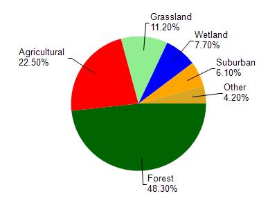
Mirror Lake is located in the Dell Creek watershed which is 133.73 mi². Land use in the watershed is primarily forest (48.30%), agricultural (22.50%) and a mix of grassland (11.20%) and other uses (18.00%). This watershed has 231.97 stream miles, 193.10 lake acres and 4,715.88 wetland acres.
Nonpoint Source Characteristics
This watershed is ranked High for runoff impacts on streams, Medium for runoff impacts on lakes and High for runoff impacts on groundwater and therefore has an overall rank of High. This value can be used in ranking the watershed or individual waterbodies for grant funding under state and county programs.However, all waters are affected by diffuse pollutant sources regardless of initial water quality. Applications for specific runoff projects under state or county grant programs may be pursued. For more information, go to surface water program grants.