Bayfield
Yes
No
No
Fish and Aquatic Life
Overview
Whittlesey Creek originates at two spring-fed streamlets from the sandy upper portion of the watershed that during normal flow conditions are internally drained and do not provide a continuous flow downstream. Just over a mile above the creek's confluence with its main tributary, North Fork Whittlesey Creek, numerous springs form a perennial stream. The stream has a fairly steep gradient in parts of the watershed, flowing through a band of highly erodible red clay soils before emptying into Chequamegon Bay. The stream has an estimated low flow of nine cubic feet per second. Its highest recorded flow was 152 cfs, with an apparent summer average between 13 and 30 cfs. The watershed is lightly populated and lightly farmed, almost half of the watershed forested. The lower four or so miles of stream, from the confluence from North Fork Whittlesey Creek to the mouth, are considered Class I trout waters (WDNR appraisal report). Two small feeders join the creek, which also support spawning trout and salmon species. At the mouth, a small stream known as Maryannes Creek or Little Whittlesey Creek, which historically joined Whittlesey Creek near the mouth, was dredged in the past to make it a separate stream discharge. The two channels now pass within thirty feet of one another. In 1993, beaver activity caused a portion of Whittlesey Creek's flow to divert to the Little Whittlesey. Some migratory Lake Superior species have been surveyed in Little Whittlesey Creek.
The stream is an important spawning and rearing stream for migratory fish, accounting for as much as 35 percent of the coho salmon spawning in Wisconsin waters. The creek's drainage area includes a portion of the Chequamegon National Forest that was recently clear cut, then drops through severely eroded red clay valleys interspersed with horse farms, orchards and open fields. Historically, the red clay soils of this geologically young watershed were anchored by white pine forest cover. This forest cover was completely removed by the early part of the century. Aspen and pastureland took the place of the protective conifers. In the 1950s and 1960s, a restoration project to stabilize banks resulted in willow plantings that have begun to die as they reach maturity. As the willows fall, they again destabilize the banks. Interspersed with the red clay soils eroding into the stream are sands that become deposited in the riverbed, rather than carried out into the bay with the clay.
Erosion has remained a problem, often closing off the mouth of the stream to such a point trout and salmon can't enter the creek to spawn. Also, the silt and sand can cause turbidity in the water, or batter the young fry in the stream. In 1991, this stream was selected as a small-scale priority watershed project. The planning phase of this project is underway. Landowner participation is necessary for the project to be completed. That participation is usually in the form of cost-shared installation of best-management practices to protect water quality. This project is fairly unusual since their are no major sources of conventional, agricultural or urban runoff pollutants. Projects planned for the watershed include bank stabilization, clearing of the channel and potentially reintroducing conifers to the watershed. There have been discussions about the application of best-management practices for forestry activities (Holiday 1995).
From: Turville-Heitz, Meg. 1999. Lake Superior Basin Water Quality Management Plan. Wisconsin Department of Natural Resources, Madison, WI.
Date 1999
Author Aquatic Biologist
General Condition
Whittlesey Creek was assessed during the 2018 listing cycle; new total phosphorus and biological (fish Index of Biotic Integrity (IBI) scores) sample data were clearly below the 2018 WisCALM listing thresholds for the Fish and Aquatic Life use. This water was meeting this designated use and was not considered impaired.
Date 2017
Author Ashley Beranek
Condition
Wisconsin has over 84,000 miles of streams, 15,000 lakes and milllions of acres of wetlands. Assessing the condition of this vast amount of water is challenging. The state's water monitoring program uses a media-based, cross-program approach to analyze water condition. An updated monitoring strategy (2015-2020) is now available. Compliance with Clean Water Act fishable, swimmable standards are located in the Executive Summary of Water Condition in 2018. See also the 'monitoring and projects' tab.
Reports
Recommendations
Natural Areas Protection
Establishment of the Whittlesey Creek National Wildlife Refuge
Nine Key Element Plan
Whittlesey Creek PWS Plan - Nine Key Element Plan - The Whittlesey Creek watershed is located in the township of Barksdale in Bayfield County. It is located in the Lake Superior drainage basin and is a direct tributary to the Lake at Chequamegon Bay. The Whittlesey Creek Priority Watershed Project plan assesses the nonpoint sources of pollution in the Whittlesey Creek Watershed and guides the implementation of nonpoint source control measures. These control measures are needed to meet specific water resource objectives for Whittlesey Creek and its tributaries. The purpose of this project is to reduce the amount of pollutants originating from nonpoint sources that reach surface water and groundwater within the Whittlesey Creek Priority Watershed Project area.
Management Goals
Wisconsin's Water Quality Standards provide qualitative and quantitative goals for waters that are protective of Fishable, Swimmable conditions [Learn more]. Waters that do not meet water quality standards are considered impaired and restoration actions are planned and carried out until the water is once again fishable and swimmable
Management goals can include creation or implementation of a Total Maximum Daily Load analysis, a Nine Key Element Plan, or other restoration work, education and outreach and more. If specific recommendations exist for this water, they will be displayed below online.
Monitoring
Monitoring the condition of a river, stream, or lake includes gathering physical, chemical, biological, and habitat data. Comprehensive studies often gather all these parameters in great detail, while lighter assessment events will involve sampling physical, chemical and biological data such as macroinvertebrates. Aquatic macroinvertebrates and fish communities integrate watershed or catchment condition, providing great insight into overall ecosystem health. Chemical and habitat parameters tell researchers more about human induced problems including contaminated runoff, point source dischargers, or habitat issues that foster or limit the potential of aquatic communities to thrive in a given area. Wisconsin's Water Monitoring Strategy was recenty updated.
Grants and Management Projects
Monitoring Projects
| WBIC | Official Waterbody Name | Station ID | Station Name | Earliest Fieldwork Date | Latest Fieldwork Date | View Station | View Data |
|---|
|
|
Watershed Characteristics
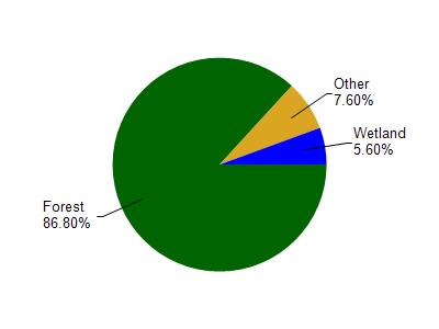
Whittlesey Creek is located in the Bayfield Peninsula Southeast watershed which is 301.48 mi². Land use in the watershed is primarily forest (86.80%), wetland (5.60%) and a mix of grassland (4.10%) and other uses (3.50%). This watershed has 453.79 stream miles, 291,749.17 lake acres and 6,560.31 wetland acres.
Nonpoint Source Characteristics
This watershed is ranked Not Ranked for runoff impacts on streams, Not Available for runoff impacts on lakes and Low for runoff impacts on groundwater and therefore has an overall rank of Low. This value can be used in ranking the watershed or individual waterbodies for grant funding under state and county programs.However, all waters are affected by diffuse pollutant sources regardless of initial water quality. Applications for specific runoff projects under state or county grant programs may be pursued. For more information, go to surface water program grants.