Waukesha
No
No
No
Fish and Aquatic Life
Overview
Silver Lake is a smaller lake (222 acres) with a maximum depth of 44 feet. The lake is a small landlocked basin partly in terminal moraine, partly in outwash deposits. At its original level, the lake discharged to the Oconomowoc River. The water is clear and much of the shore bottom is sandy. Largemouth bass and panfish constitute the fishery. Walleyes are stocked. Carp are present, but are not a problem. WDNR recently acquired public access by purchasing a restaurant parking site adjacent to the lake. Public access has been developed and is open. A Boy Scout camp occupies some shoreline and accommodates up to 400 boys each summer week. A shallow marsh adjoins the west shore and offers some incentive for waterfowl to nest here. In 1943, a waterfowl refuge was suggested for this area.
The lake association has been fairly active in lake management. Some of the issues addressed in the last five years include construction activities associated with a sanitary sewer extension, low water levels, zoning issues associated with an industrial park in the watershed, water quality and public access.
In 1992, the Town of Summit received a Wisconsin Lake Management Planning Grant and hired the U.S Geological Survey to monitor the water quality between 1992 and 1996. In addition, a land use inventory and a sensitive area assessment are to be conducted in the watershed to identify areas that should be protected from development. WDNR has acquired a public access site on the north shore of the lake.
Zebra mussel larvae have been identified in the watershed by a representative of the UW Sea Grant Institute. No larvae or adults have been found in Silver Lake (1994).
Date 2002
Author Aquatic Biologist
Historical Description
A small landlocked basin partly in terminal moraine, partly in outwash deposits. At its original level the lake discharged to the Oconomowoc River. The water is clear and much of the shore bottom is sandy. Largemouth bass and pan fish constitute the fishery. Carp are present but not in problem proportions. Public access without parking is provided by a road contiguous with the shore. A Boy Scout camp occupies some shore line and accommodates up to 400 boys each summer week. A large beach resort has counted nearly 1,500 swimmers per week end during midsummer. Shallow marsh adjoins the west shore offering some incentive for waterfowl to nest here. In 1943, a waterfowl refuge was suggested for this area. Source: 1963, Surface Water Resources of Waukesha County Silver Lake T7N, R17E, Sections 9 and 16 Surface Acres = 222, S.D.F., 1.29, Maximum Depth = 44 feet
Date 1963
Author Surface Water Inventory Of Wisconsin
General Condition
Silver Lake was evaluated every two years between 2014 and 2020 for phosphorus and algae and was found to be in good condition. This lake is on the healthy waters list.
Date 2019
Author Ashley Beranek
Condition
Wisconsin has over 84,000 miles of streams, 15,000 lakes and milllions of acres of wetlands. Assessing the condition of this vast amount of water is challenging. The state's water monitoring program uses a media-based, cross-program approach to analyze water condition. An updated monitoring strategy (2015-2020) is now available. Compliance with Clean Water Act fishable, swimmable standards are located in the Executive Summary of Water Condition in 2018. See also the 'monitoring and projects' tab.
Reports
Recommendations
Monitor Water Quality or Sediment
Management Goals
Wisconsin's Water Quality Standards provide qualitative and quantitative goals for waters that are protective of Fishable, Swimmable conditions [Learn more]. Waters that do not meet water quality standards are considered impaired and restoration actions are planned and carried out until the water is once again fishable and swimmable
Management goals can include creation or implementation of a Total Maximum Daily Load analysis, a Nine Key Element Plan, or other restoration work, education and outreach and more. If specific recommendations exist for this water, they will be displayed below online.
Monitoring
Monitoring the condition of a river, stream, or lake includes gathering physical, chemical, biological, and habitat data. Comprehensive studies often gather all these parameters in great detail, while lighter assessment events will involve sampling physical, chemical and biological data such as macroinvertebrates. Aquatic macroinvertebrates and fish communities integrate watershed or catchment condition, providing great insight into overall ecosystem health. Chemical and habitat parameters tell researchers more about human induced problems including contaminated runoff, point source dischargers, or habitat issues that foster or limit the potential of aquatic communities to thrive in a given area. Wisconsin's Water Monitoring Strategy was recenty updated.
Grants and Management Projects
Monitoring Projects
| WBIC | Official Waterbody Name | Station ID | Station Name | Earliest Fieldwork Date | Latest Fieldwork Date | View Station | View Data |
|---|
| 779800 | Silver Lake | 683145 | Silver Lake - Deep Hole | 9/17/1973 | 3/27/2026 | Map | Data |
| 779800 | Silver Lake | 10007215 | Silver Lake | 6/1/1995 | 8/31/2023 | Map | Data |
| 779800 | Silver Lake | 10017539 | Silver Lake - Access Off Valley Rd | 6/1/2006 | 5/28/2026 | Map | Data |
|
Watershed Characteristics
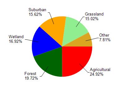
Silver Lake is located in the Oconomowoc River watershed which is 130.86 mi². Land use in the watershed is primarily agricultural (24.90%), forest (19.70%) and a mix of wetland (16.90%) and other uses (38.40%). This watershed has 136.99 stream miles, 2,858.66 lake acres and 11,105.19 wetland acres.
Nonpoint Source Characteristics
This watershed is ranked Not Available for runoff impacts on streams, Not Available for runoff impacts on lakes and High for runoff impacts on groundwater and therefore has an overall rank of High. This value can be used in ranking the watershed or individual waterbodies for grant funding under state and county programs.However, all waters are affected by diffuse pollutant sources regardless of initial water quality. Applications for specific runoff projects under state or county grant programs may be pursued. For more information, go to surface water program grants.