")
3.39 Miles
2.03 - 5.42
Macroinvertebrate, Coldwater
Good
Bayfield
Yes
No
No
Fish and Aquatic Life
Overview
This river flows north off the Bayfield Peninsula Ridge into Sand Bay on Lake Superior, moving large amounts of clay and sand that have formed a bar out toward Sand Island. Sampling conducted in the early 1980s by the U.S. Geological Survey measured discharges as high as 5,000 tons per day of suspended sediment and 192 tons per day of dissolved solids. In its uppermost reaches, it flows through an extensive wetland area where beaver are common. The upper 70 percent of the river is intermittent. Many small bottom springs and spring streamlets flow into the Sand River about four miles south of its mouth. These are largely responsible for the lower four miles being able to support trout. Brook trout are common in this lower reach, and migratory runs from Lake Superior occur.
This river is periodically subjected to destructive flash floods. Flood stages as high as 12 feet above normal have been recorded. The floods scour most in-stream cover. The upstream reaches are primarily upland hardwood that may periodically be subjected to clearcutting and logging traffic, while the lower reaches are bordered by dense stands of willow.
The Sand River forms a small estuary where it enters Lake Superior, resulting in an area of coastal wetlands that provides good fish habitat. This portion of the Lake Superior Shoreline in Sand Bay is part of the Apostle Island National Lakeshore. The coastal wetlands evaluation identified Sand Bay as the site of priority wetlands (see discussion, above). The river itself, besides supporting trout, provides habitat for several warm water species of game and forage fish. The lower portion of the river flows through the Red Cliff Indian Reservation, while the upper parts are mostly county forest. The headwaters areas are privately owned.
Water quality analysis was conducted on this river to determine background levels of metals in the region. Due to wetland areas, springtime waters contained large amounts of particulate matter, much of it clay. This stream was identified in the coastal wetlands evaluation as an aquatic priority site (Epstein 1997). While the headwaters are near the Bayfield Sand Barrens subsection, and may be influenced by the area, the stream is contained with in the Lake Superior Clay Plain subsection. Of the 20 insect aquatic taxa found in this effort, five are considered rare in Wisconsin. Significant management concerns identified by the survey include turbidity, low flow, exotic species encroachment and bank erosion.
The Sand River supports regionally significant diversity among its aquatic insects. This should an important management consideration across administrative boundaries, as few of the area's streams are confined to a single-owner watershed.
Date 1999
Author Aquatic Biologist
Condition
Wisconsin has over 84,000 miles of streams, 15,000 lakes and milllions of acres of wetlands. Assessing the condition of this vast amount of water is challenging. The state's water monitoring program uses a media-based, cross-program approach to analyze water condition. An updated monitoring strategy (2015-2020) is now available. Compliance with Clean Water Act fishable, swimmable standards are located in the Executive Summary of Water Condition in 2018. See also the 'monitoring and projects' tab.
Reports
Management Goals
Wisconsin's Water Quality Standards provide qualitative and quantitative goals for waters that are protective of Fishable, Swimmable conditions [Learn more]. Waters that do not meet water quality standards are considered impaired and restoration actions are planned and carried out until the water is once again fishable and swimmable
Management goals can include creation or implementation of a Total Maximum Daily Load analysis, a Nine Key Element Plan, or other restoration work, education and outreach and more. If specific recommendations exist for this water, they will be displayed below online.
Monitoring
Monitoring the condition of a river, stream, or lake includes gathering physical, chemical, biological, and habitat data. Comprehensive studies often gather all these parameters in great detail, while lighter assessment events will involve sampling physical, chemical and biological data such as macroinvertebrates. Aquatic macroinvertebrates and fish communities integrate watershed or catchment condition, providing great insight into overall ecosystem health. Chemical and habitat parameters tell researchers more about human induced problems including contaminated runoff, point source dischargers, or habitat issues that foster or limit the potential of aquatic communities to thrive in a given area. Wisconsin's Water Monitoring Strategy was recenty updated.
Grants and Management Projects
| Project Name (Click for Details) | Year Started |
|---|
|
|
Monitoring Projects
| WBIC | Official Waterbody Name | Station ID | Station Name | Earliest Fieldwork Date | Latest Fieldwork Date | View Station | View Data |
|---|
| 2883100 | Sand River | 043098 | Sand River at Hwy 13 | | | Map | Data |
| 2883100 | Sand River | 043019 | Sand River at Sth 13 (SR02) | | | Map | Data |
|
Watershed Characteristics
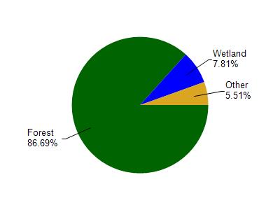
Sand River is located in the Bayfield Peninsula Northwest watershed which is 236.05 mi². Land use in the watershed is primarily forest (86.60%), wetland (7.80%) and a mix of grassland (4.60%) and other uses (0.90%). This watershed has 473.06 stream miles, 43,216.55 lake acres and 6,677.27 wetland acres.
Nonpoint Source Characteristics
This watershed is ranked Not Ranked for runoff impacts on streams, Not Available for runoff impacts on lakes and Low for runoff impacts on groundwater and therefore has an overall rank of Low. This value can be used in ranking the watershed or individual waterbodies for grant funding under state and county programs.However, all waters are affected by diffuse pollutant sources regardless of initial water quality. Applications for specific runoff projects under state or county grant programs may be pursued. For more information, go to surface water program grants.
Sand River is considered a Macroinvertebrate, Coldwater under the state's Natural Community Determinations.
Natural communities (stream and lake natural communities) represent model results and DNR staff valiation processes that confirm or update predicted conditions based on flow and temperature modeling from historic and current landscape features and related variables. Predicated flow and temperatures for waters are associated predicated fish assemblages (communities). Biologists evaluate the model results against current survey data to determine if the modeled results are corect and whether biological indicators show water quaity degradation. This analysis is a core component of the state's resource management framework. Wisconsin's Riverine Natural Communities.