Monroe
Yes
Yes
Yes
Fish and Aquatic Life
Overview
Big Creek flows into the Black River from the southeast. This Class II trout stream is in large part protected by state ownership as the Big Creek and Evans Pond State Fishery Areas. Despite extensive public ownership, habitat in the stream is still lacking. Active streambank erosion is rare in the fishery areas along Big Creek, however several tributary streams contribute sand to Big Creek. As a result, deep holes and riffle areas exist only where in-stream flow is redirected and stream bottom scour results.
The sandy soils of this watershed are easily disturbed and do not recover quickly. Consequently, erosion near permanent or intermittent waterbodies is difficult to prevent. Extending streambank protection areas, installing scour structures, and preventing streambank erosion along Big Creek and its tributaries would improve the available habitat and create new habitat (Wright, Koperski).
From: Koperksi, Cindy. 1999. Black River Water Quality Management Plan (draft). Wisconsin Department of Natural Resources, Madison, WI.
Date 1999
Author Cynthia Koperski
General Condition
Big Creek is a one and a half-mile cool-cold mainstem stream and is listed on the impaired waters list for total phosphorus levels exceeding the statewide criteria. Big Creek was surveyed at Acorn Ave. The fish IBI rating was excellent and the community was dominated by brook trout, white suckers, western blacknose dace, and burbot.
The qualitative habitat score for this site was 53, which is good. The stream was wide and relatively deep and the riparian buffer was protected. Factors limiting habitat include fine sediment and a lack of fish cover. Although find sediment deposition was an issue to habitat, this stream most likely has a naturally sandy bottom.
The HBI and MIBI ratings were excellent and there is no apparent organic pollution at this stream site. Total phosphorus monitoring indicates concentrations exceed the statewide criteria with a median concentration of 0.2165 mg/L. This high phosphorus concentration is consistent with the impaired waters listing for TP.
Date 2017
Author Camille Bruhn
Condition
Wisconsin has over 84,000 miles of streams, 15,000 lakes and milllions of acres of wetlands. Assessing the condition of this vast amount of water is challenging. The state's water monitoring program uses a media-based, cross-program approach to analyze water condition. An updated monitoring strategy (2015-2020) is now available. Compliance with Clean Water Act fishable, swimmable standards are located in the Executive Summary of Water Condition in 2018. See also the 'monitoring and projects' tab.
Reports
Recommendations
Monitor Water Quality or Sediment
Monitor Aquatic Biology
Engage Volunteers in Monitoring/Restoration
Continue monitoring water quality parameters or coordinate for volunteers to monitor streams that may have high phosphorus levels that exceed statewide criteria.
Best Management Practices, Implement
Several stream sites throughout the Big-Douglas watershed and Rathbone-Soper subwatershed have banks that are highly eroded. Grant programs and funding opportunities to seek BMP support should be pursued as relevant in the future.
Best Management Practices, Implement
In areas with heavy grazing, managed grazing and rotational grazing could be implemented to protect riparian corridors. Other agricultural practices such as buffers, cover crops, no-till farming, and nutrient management plans could help reduce erosion and runoff to streams.
Engage Volunteers in Monitoring/Restoration
Citizen volunteers can also help by monitoring streams for phosphorus concentrations to identify areas that may need more nutrient reduction practices.
Information and Education
DNR should work on outreach efforts with landowners and County conservation staff to increase the size and condition of riparian areas in order to buffer stream systems, create fish habitat, and decrease the amount of fine sediments entering the streams.
Habitat Restoration - Instream
Habitat improvements could also be implemented on streams that have documented steep eroding banks if funding becomes available.
Management Goals
Wisconsin's Water Quality Standards provide qualitative and quantitative goals for waters that are protective of Fishable, Swimmable conditions [Learn more]. Waters that do not meet water quality standards are considered impaired and restoration actions are planned and carried out until the water is once again fishable and swimmable
Management goals can include creation or implementation of a Total Maximum Daily Load analysis, a Nine Key Element Plan, or other restoration work, education and outreach and more. If specific recommendations exist for this water, they will be displayed below online.
Monitoring
Monitoring the condition of a river, stream, or lake includes gathering physical, chemical, biological, and habitat data. Comprehensive studies often gather all these parameters in great detail, while lighter assessment events will involve sampling physical, chemical and biological data such as macroinvertebrates. Aquatic macroinvertebrates and fish communities integrate watershed or catchment condition, providing great insight into overall ecosystem health. Chemical and habitat parameters tell researchers more about human induced problems including contaminated runoff, point source dischargers, or habitat issues that foster or limit the potential of aquatic communities to thrive in a given area. Wisconsin's Water Monitoring Strategy was recenty updated.
Grants and Management Projects
Monitoring Projects
| WBIC | Official Waterbody Name | Station ID | Station Name | Earliest Fieldwork Date | Latest Fieldwork Date | View Station | View Data |
|---|
| 1692900 | Big Creek | 10013943 | Big Creek(Cataract)Station 2-Ne 1/4 Sw 1/4 Sec.7-Starta At Acorn Ave. Bridge Crossing | | | Map | Data |
| 1692900 | Big Creek | 10013961 | Big Creek(Cataract)Station 4-Ne 1/4 Nw 1/4 S20 | | | Map | Data |
| 1692900 | Big Creek | 10013964 | Big Creek(Cataract)Station 5-Sw 1/4 Ne 1/4 S28 | | | Map | Data |
| 1692900 | Big Creek | 10020509 | Big Creek St. 2 1800ft Downstream Of South Line Of S20 | | | Map | Data |
| 1692900 | Big Creek | 423224 | Big Creek at Acorn Ave | 7/18/2005 | 1/1/2015 | Map | Data |
| 1692900 | Big Creek | 10013960 | Big Creek(Cataract)Station 3-Sw 1/4 Nw 1/4 S17-Starts At Section Line. | | | Map | Data |
| 1692900 | Big Creek | 423217 | Big Creek - Big Creek | 6/23/2003 | 10/14/2004 | Map | Data |
| 1692900 | Big Creek | 10013968 | Big Creek(Cataract)Station 2-1975-Nw 1/4 Se 1/4 S20 | | | Map | Data |
| 1692900 | Big Creek | 10022450 | Big Creek (Cataract) - State Lands Parking Area Off Acorn Ave. | | | Map | Data |
| 1692900 | Big Creek | 10010235 | Big Creek Li-63 | | | Map | Data |
|
Watershed Characteristics
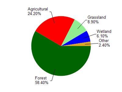
Big Creek is located in the Big and Douglas Creeks watershed which is 210.33 mi². Land use in the watershed is primarily forest (58.40%), agricultural (24.20%) and a mix of grassland (8.90%) and other uses (8.50%). This watershed has 375.17 stream miles, 473.57 lake acres and 7,564.97 wetland acres.
Nonpoint Source Characteristics
This watershed is ranked High for runoff impacts on streams, Not Available for runoff impacts on lakes and Medium for runoff impacts on groundwater and therefore has an overall rank of Medium. This value can be used in ranking the watershed or individual waterbodies for grant funding under state and county programs.However, all waters are affected by diffuse pollutant sources regardless of initial water quality. Applications for specific runoff projects under state or county grant programs may be pursued. For more information, go to surface water program grants.