Waupaca
No
No
No
Fish and Aquatic Life
Overview
The south branch of the Little Wolf River has its origin in the Iola Millpond. There are some problems in the watershed with sediments and habitat deterioration from streambank pasturing.
From: Bougie, Cheryl A., Kosmond, Lisa D, and Watermolen, Dreux J. 1996. Wolf River Basin Water Quality Management Plan. Wisconsin Department of Natural Resources, Madison, WI.
Date 1996
Author Cheryl Bougie
General Condition
The South Branch of the Little Wolf River (also known as Mack Creek) was assessed during the 2018 listing cycle; new total phosphorus sample data were clearly below the 2018 WisCALM listing thresholds for the Fish and Aquatic Life use. This water was meeting this designated use and was not considered impaired.
Date 2017
Author Ashley Beranek
Condition
Wisconsin has over 84,000 miles of streams, 15,000 lakes and milllions of acres of wetlands. Assessing the condition of this vast amount of water is challenging. The state's water monitoring program uses a media-based, cross-program approach to analyze water condition. An updated monitoring strategy (2015-2020) is now available. Compliance with Clean Water Act fishable, swimmable standards are located in the Executive Summary of Water Condition in 2018. See also the 'monitoring and projects' tab.
Reports
Recommendations
Citizen-Based Stream Monitoring
Collect chemical, physical, and/or biological water quality data to assess the current overall stream health. The data can inform management decisions and may be used to identify impaired waters for biennial lists.
Citizen-Based Stream Monitoring
Collect chemical, physical, and/or biological water quality data to assess the current overall stream health. The data can inform management decisions and may be used to identify impaired waters for biennial lists.
Citizen-Based Stream Monitoring
Collect chemical, physical, and/or biological water quality data to assess the current overall stream health. The data can inform management decisions and may be used to identify impaired waters for biennial lists.
Lake Management Plan Implementation
Review existing data on lake and watershed to define data gaps. Initiate public involvement/information program. Water quality monitoring. Event-related nonpoint source runoff monitoring. Macrophyte survey. Identification of sediment loading and sources of sedimentation. Base map of lake and watershed preparation.
Monitor Water Quality or Sediment
Monitoring of temperature, phosphorus, and sediment concentrations above and below Big Falls and Manawa should continue to assess the impacts from the millponds on the water quality of the River.
Water Quality Planning
The South Branch Little Wolf River Watershed is approximately 165 square miles and is in Waupaca and Portage Counties. It also contains 64 miles of the South Branch of the Little Wolf River. The South Branch Little Wolf River watershed drains portions of the planning area generally to the north and east of the city of Waupaca and contains the South Branch Little Wolf River as the major water feature. Drainage generally flows northeastward through small tributaries to the Little Wolf River and eventually drains into the Wolf River and the Lake Winnebago/Fox River/Green Bay system. This watershed ranks high for lakes and groundwater and low for streams according to the WDNR's draft Upper Fox River Basin Plan (1997). No point-source dischargers are contained within the Planning Area for this watershed.
Management Goals
Wisconsin's Water Quality Standards provide qualitative and quantitative goals for waters that are protective of Fishable, Swimmable conditions [Learn more]. Waters that do not meet water quality standards are considered impaired and restoration actions are planned and carried out until the water is once again fishable and swimmable
Management goals can include creation or implementation of a Total Maximum Daily Load analysis, a Nine Key Element Plan, or other restoration work, education and outreach and more. If specific recommendations exist for this water, they will be displayed below online.
Monitoring
Monitoring the condition of a river, stream, or lake includes gathering physical, chemical, biological, and habitat data. Comprehensive studies often gather all these parameters in great detail, while lighter assessment events will involve sampling physical, chemical and biological data such as macroinvertebrates. Aquatic macroinvertebrates and fish communities integrate watershed or catchment condition, providing great insight into overall ecosystem health. Chemical and habitat parameters tell researchers more about human induced problems including contaminated runoff, point source dischargers, or habitat issues that foster or limit the potential of aquatic communities to thrive in a given area. Wisconsin's Water Monitoring Strategy was recenty updated.
Grants and Management Projects
Monitoring Projects
| WBIC | Official Waterbody Name | Station ID | Station Name | Earliest Fieldwork Date | Latest Fieldwork Date | View Station | View Data |
|---|
| 272600 | South Branch Little Wolf River | 10021240 | South Branch Of Little Wolf At Confluence Of Little Wolf River (28) | 8/5/2007 | 8/5/2007 | Map | Data |
| 272600 | South Branch Little Wolf River | 10008352 | South Branch Little Wolf River 3 - Casey Rd | 1/1/2015 | 1/1/2015 | Map | Data |
| 272600 | South Branch Little Wolf River | 10040608 | SB Little Wolf River at Pier 1/4 mi US from CTH E bridge | 7/14/2003 | 8/31/2013 | Map | Data |
| 272600 | South Branch Little Wolf River | 10016643 | S. Branch Little Wolf R. - 20 Feet Upstream From Bridge Sunnyview Rd. | 9/25/2001 | 1/1/2015 | Map | Data |
| 272600 | South Branch Little Wolf River | 10008375 | South Branch Littel Wolf River 1 - (Sth 22) | 6/4/1980 | 10/31/1980 | Map | Data |
| 272600 | South Branch Little Wolf River | 10030793 | South Branch Little Wolf River - 100 ft downstream CTH E | 4/26/2004 | 10/2/2005 | Map | Data |
| 272600 | South Branch Little Wolf River | 10008354 | South Branch Little Wolf River 2 (at Mouth Of Trib) | | | Map | Data |
| 272600 | South Branch Little Wolf River | 10031865 | South Branch Little Wolf River DS Casey Rd | 9/28/2010 | 1/1/2015 | Map | Data |
| 272600 | South Branch Little Wolf River | 10030795 | South Branch Little Wolf River - 600 ft downstream of private drive west of hwy 110/54/22 | 5/7/2004 | 10/2/2005 | Map | Data |
| 272600 | South Branch Little Wolf River | 10038005 | South Branch Little Wolf River at County Road K | 8/1/2012 | 1/1/2015 | Map | Data |
|
Watershed Characteristics
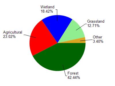
South Branch Little Wolf River is located in the South Branch Little Wolf River watershed which is 160.29 mi². Land use in the watershed is primarily forest (42.40%), agricultural (23%) and a mix of wetland (18.40%) and other uses (16.10%). This watershed has 166.00 stream miles, 2,070.64 lake acres and 19,091.22 wetland acres.
Nonpoint Source Characteristics
This watershed is ranked Low for runoff impacts on streams, High for runoff impacts on lakes and High for runoff impacts on groundwater and therefore has an overall rank of High. This value can be used in ranking the watershed or individual waterbodies for grant funding under state and county programs.However, all waters are affected by diffuse pollutant sources regardless of initial water quality. Applications for specific runoff projects under state or county grant programs may be pursued. For more information, go to surface water program grants.