Dane
No
Yes
Yes
Fish and Aquatic Life
Overview
Sixmile Creek Water quality in Six Mile Creek's 12-mile length is generally good, supporting a limited forage fishery west of Hwy 113, a diverse forage and warm water sport fishery from Hwy 113 to Lake Mendota, and abundant spawning areas. Six Mile Creek's 43-square-mile watershed is predominately agricultural (63%) but also includes the rapidly urbanizing village of Waunakee (WDNR 1996b). From 1995 to 2000, the village grew by 25%, to roughly 9,000 people. Waunakee's wastewater effluent is treated at the Madison Metropolitan Sewerage District (MMSD). Upstream of the village, Waunakee Marsh traps sediment from the area's row-cropped fields, which is adversely affecting the wetland's ecology.
Downstream of the village of Waunakee to Lake Mendota urban development threatens the stream. Several small rural communities and large developments lie in the drainage area outside of the village, contributing pollutants from agricultural land spreading, construction site erosion, and habitat loss. In Summer 1991, Stokely's wastewater spray irrigation system--which landspreads its canning waste on 178 acres just outside of the village--malfunctioned, causing fish kills in Six Mile Creek. This incident was not the first caused by Stokely's landspreading operations. Fish kills in Six Mile Creek occurred three times in a short two-year period. The July 12, 1991 spill released 6,000 gallons of untreated wastewater directly into the creek. This spill followed on the heels of a pipe leak July 1, 1991, during which 85,000 gallons of wastewater drained into the creek. In 1990 a spill released to the creek 230,000 gallons from a pipe leak (WDNR 1996a). Fish managers estimate hundreds to thousands of pike, walleye, bass etc., fingerlings were killed in the last incident, as a fish rearing marsh for Lake Mendota is located just off the creek.
A recent fishkill on Six Mile Creek on July 2, 2001, resulted in the death of over 200 fish (white suckers and creek chubs) near Madison Street Bridge in Waunakee. The fishkill coincided with the flushing of a new water main. New water mains are typically more heavily chlorinated as a means to sanitize and disinfect before bringing the main online. It s likely that this flushing event depressed oxygen levels or contained high levels of chlorine, resulting in a fishkill.
Date 2002
Author Aquatic Biologist
Historical Description
Six Mile Creek originates in Section 2 of Springfield Township (T8N, R8E) and flows east to Waunakee and south to the north end of Lake Mendota. The watershed once encompassed plentiful wetlands, but many of these areas have been drained, filled, or altered for the development of more cropland. Two major remaining wetlands are the Waunakee Marsh in the northwestern part of the watershed and the marshes near the creek's mouth on Lake Mendota (Dane Cty. Reg. Plann. Comm. 1979a). Channel alterations in the upper reaches of the creek and sewage effluent contribute to the high sediment load. Much of the creek bottom is heavily silted. The marshes serve as sediment traps and also contrIbute ground water seepage to the creek. Six Mile Creek supports a diverse forage and warm water game fishery and offers abundant spawning areas for fish from Lake Mendota. The creek has a history (as recent as 1980) of fishkills near Waunakee caused by discharges of biochemical oxygen demand (BOD) waste from a canning factory with a defective land irrigation disposal system. There are no other known point sources of pollution on the creek and water quality is good. Public access is available at state and city parks, the DNR-owned portion of the Waunakee Marsh and 19 road crossings. The Waunakee Marsh supports a varied habitat for pheasants, waterfowl, rabbits, deer, and furbearers.
Fish species: bowfin, central mudminnow, northern pike, stoneroller (unsp.), common carp, golden and common shiner, southern redbelly dace, bluntnose and fathead minnow, creek chub, white sucker, pearl dace, bullhead (unsp.), black and yellow bullhead, channel catfish, brook stickleback, white bass, green sunfish, pumpkinseed, blueglll, largemouth bass, white and black crappie, yellow perch, freshwater drum, and walleye.
Six Mile Creek -T8N, R9E, Sec. 28, Surface acres = 14.5, Length = 12 miles, Stream order = II, Gradient = 7.2 ft/mile, Base discharge = 16.4 cfs.
From: Day, Elizabeth A.; Grzebieniak, Gayle P.; Osterby, Kurt M.; and Brynildson, Clifford L., 1985. Lake and Stream Classification Project. Surface Water Resources of Dane County, Wisconsin Department of Natural Resources, Madison, WI.
Date 1985
Author Aquatic Biologist
Impaired Waters
Six Mile Creek, from mile 8.5 to 10, was evaluated in the 2022 cycle: phosphorus levels were above listing thresholds as outlined in 2022 WisCALM. This stream was added to the 2022 Impaired Waters List.
Date 2022
Author Ashley Beranek
Impaired Waters
The 2018 assessments of Sixmile Creek (miles 0-8.5) showed continued impairment by phosphorus; new total phosphorus sample data overwhelmingly exceeded the 2018 WisCALM listing criteria for the Fish and Aquatic Life use. However, available biological data did not indicate impairment (i.e. no macroinvertebrate or fish Index of Biotic Integrity (IBI) scored in the "poor" condition category). Based on the most updated information, no change in the existing impaired waters listing was needed.
Date 2017
Author Ashley Beranek
Impaired Waters
Sixmile Creek (805500) was assessed during the 2016 listing cycle; total phosphorus sample data overwhelmingly exceed 2016 WisCALM listing thresholds for the Fish and Aquatic Life use, however, available biological data do not indicate impairment (i.e. no macroinvertebrate or fish Index of Biotic Integrity (IBI) scored in the "poor" condition category). Chloride sample data clearly met 2016 WisCALM chronic and acute listing criteria for the Fish and Aquatic Life use.
Date 2015
Author Aaron Larson
Condition
Wisconsin has over 84,000 miles of streams, 15,000 lakes and milllions of acres of wetlands. Assessing the condition of this vast amount of water is challenging. The state's water monitoring program uses a media-based, cross-program approach to analyze water condition. An updated monitoring strategy (2015-2020) is now available. Compliance with Clean Water Act fishable, swimmable standards are located in the Executive Summary of Water Condition in 2018. See also the 'monitoring and projects' tab.
Reports
Recommendations
Citizen-Based Stream Monitoring
Collect chemical, physical, and/or biological water quality data to assess the current overall stream health. The data can inform management decisions and may be used to identify impaired waters for biennial lists.
Citizen-Based Stream Monitoring
Collect chemical, physical, and/or biological water quality data to assess the current overall stream health. The data can inform management decisions and may be used to identify impaired waters for biennial lists.
Citizen-Based Stream Monitoring
Collect chemical, physical, and/or biological water quality data to assess the current overall stream health. The data can inform management decisions and may be used to identify impaired waters for biennial lists.
Citizen-Based Stream Monitoring
Collect chemical, physical, and/or biological water quality data to assess the current overall stream health. The data can inform management decisions and may be used to identify impaired waters for biennial lists.
Runoff Grant
wet detention pond, Waunakee
County Land and Water Management Plan
Dane County will undertake a River Planning Grant project to incorporate an urban analysis component within the SWAT (Soil and Water Assessment Tool) model. Project deliverables are as follows: 1.) Develop a revised SWAT model that can reliably simulate runoff from both urban and rural sources within the Six Mile Creek Watershed, 2.) Provide a summary of the modeling approach and modeling results in the final report; 3.) revised SWAT model will be an open source model available at no charge for other users.
Sewer Service Area Planning
Waunakee is a growing community and works cooperatively with the Town of Westport to provide municipal urban services to commercial and residential customers in the incorporated area.
Management Goals
Wisconsin's Water Quality Standards provide qualitative and quantitative goals for waters that are protective of Fishable, Swimmable conditions [Learn more]. Waters that do not meet water quality standards are considered impaired and restoration actions are planned and carried out until the water is once again fishable and swimmable
Management goals can include creation or implementation of a Total Maximum Daily Load analysis, a Nine Key Element Plan, or other restoration work, education and outreach and more. If specific recommendations exist for this water, they will be displayed below online.
Monitoring
Monitoring the condition of a river, stream, or lake includes gathering physical, chemical, biological, and habitat data. Comprehensive studies often gather all these parameters in great detail, while lighter assessment events will involve sampling physical, chemical and biological data such as macroinvertebrates. Aquatic macroinvertebrates and fish communities integrate watershed or catchment condition, providing great insight into overall ecosystem health. Chemical and habitat parameters tell researchers more about human induced problems including contaminated runoff, point source dischargers, or habitat issues that foster or limit the potential of aquatic communities to thrive in a given area. Wisconsin's Water Monitoring Strategy was recenty updated.
Grants and Management Projects
Monitoring Projects
| WBIC | Official Waterbody Name | Station ID | Station Name | Earliest Fieldwork Date | Latest Fieldwork Date | View Station | View Data |
|---|
| 805500 | Sixmile Creek | 10043693 | Sixmile Creek at April Lane Stormwater outfall | 1/1/2015 | 6/8/2015 | Map | Data |
| 805500 | Sixmile Creek | 10040382 | Sixmile Creek at Division St and Knightsbridge Rd | 8/5/2017 | 10/2/2024 | Map | Data |
| 805500 | Sixmile Creek | 10039445 | Sixmile Creek on DNR managed land - After tunnel | | | Map | Data |
| 805500 | Sixmile Creek | 133061 | Sixmile Creek at Division St. | 9/2/1975 | 10/13/2015 | Map | Data |
| 805500 | Sixmile Creek | 133312 | Sixmile Creek at CTH M | 8/7/1980 | 1/1/2015 | Map | Data |
| 805500 | Sixmile Creek | 133397 | Sixmile Creek at Woodland Dr | 5/26/1994 | 10/5/1995 | Map | Data |
| 805500 | Sixmile Creek | 10040856 | Sixmile Creek at Woodland Dr | 6/30/2013 | 9/25/2023 | Map | Data |
| 805500 | Sixmile Creek | 10039449 | Sixmile Creek on DNR managed land - below 3rd obstruction | | | Map | Data |
| 805500 | Sixmile Creek | 10042332 | Sixmile Cr confluence with Dorn Cr | 8/31/2006 | 9/30/2017 | Map | Data |
| 805500 | Sixmile Creek | 104419 | Sixmile Creek | | | Map | Data |
| 805500 | Sixmile Creek | 133064 | Sixmile Creek at Woodland Dr Brg | 8/20/1980 | 4/23/2024 | Map | Data |
| 805500 | Sixmile Creek | 10010967 | Sixmile Creek at Sth 113 | 10/9/1990 | 10/30/2023 | Map | Data |
| 805500 | Sixmile Creek | 133059 | Sixmile Creek at STH 113 and Division St | 8/28/1990 | 10/13/2015 | Map | Data |
| 805500 | Sixmile Creek | 10010966 | Sixmile Creek - US of Mill Rd | 7/17/2007 | 8/29/2023 | Map | Data |
| 805500 | Sixmile Creek | 10012036 | Sixmile Creek - Waunakee Park at third bridge | 6/6/2010 | 10/18/2023 | Map | Data |
| 805500 | Sixmile Creek | 10039448 | Sixmile Creek on DNR managed land - Right as trees open up | | | Map | Data |
| 805500 | Sixmile Creek | 10039446 | Sixmile Creek on DNR managed land - Long cut bank on left side | | | Map | Data |
| 805500 | Sixmile Creek | 10043695 | Sixmile Creek at North Madison Street. | 1/1/2015 | 6/9/2015 | Map | Data |
| 805500 | Sixmile Creek | 133063 | Sixmile Creek at Mill Rd Bridge | 9/2/1975 | 8/12/2020 | Map | Data |
|
Watershed Characteristics
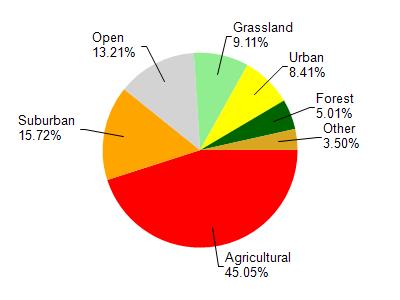
Sixmile Creek is located in the Six Mile and Pheasant Branch Creeks watershed which is 119.45 mi². Land use in the watershed is primarily agricultural (45%), suburban (15.70%) and a mix of open (13.20%) and other uses (26.00%). This watershed has 145.61 stream miles, 9,959.08 lake acres and 2,759.80 wetland acres.
Nonpoint Source Characteristics
This watershed is ranked Not Available for runoff impacts on streams, Not Available for runoff impacts on lakes and High for runoff impacts on groundwater and therefore has an overall rank of High. This value can be used in ranking the watershed or individual waterbodies for grant funding under state and county programs.This water is ranked High Stream for individual Rivers based on runoff problems and the likelihood of success from project implementation.