Waukesha
No
No
No
Fish and Aquatic Life
Overview
Nagawicka Lake is a large mesotrophic drainage lake on the Bark River. The village of Delafield lies on the southwest edge of the lake and there is significant home and cottage development around the lake. The lake has a good Warm Water Sport Fishery and high recreational use. The lake's major issues are development pressures, lack of stormwater management, and shoreline disturbance. Nutrient and sediment loading from upstream, surrounding agricultural and urban runoff, and erosion from construction sites have affected the lake's quality. Septic systems in non-sewered areas may also be a problem, though almost the entire lake lies within a sewer service area. Applications to conduct dredging along the lake's west shore have been submitted. Recently, the city of Delafield purchased property along the lake to connect with the downtown corridor trail system. There are no lake association or Self-Help monitoring volunteers for this lake. A WDNR Lake Planning Grant could fund development of a long-term lake management plan for the lake, including determining the lake management institutional structure, such as developing a lake association, and protection strategies.
Date 2002
Author Aquatic Biologist
Historical Description
Source: 1963, Surface Water Resources of Waukesha County Nagawicka Lake T7N, R18E, Sections 8 and 17
A large deep lake occupying the valley drained by the Bark River in the interlobate moraine. The water is clear and most of the bottom is gravel. Both inlet and outlet are traversable by boat with the exception of the dam site. The fishery consists of northern pike, walleyes, large and smallmouth bass, and pan fish. Fishing success has been above average for a number of years. A major-use problem is weeds, which have required treatment nearly every year in the past decade. One county park provides excellent access for multiple use on the east shore. In addition to the lake proper there are 32 acres of water in an extensive channel system on the west shore. A summer camp of 550 capacity additionally provides for high summer use of the lake shores. A small northernmost basin is bordered by timber swamp of high aesthetic and wildlife value. In 1942, a Department evaluation Suggested a waterfowl refuge here.
Surface Acres = 957, S.D.F. = 1.98, Maximum Depth = 90 feet
Date 1963
Author Surface Water Inventory Of Wisconsin
General Condition
Nagawicka Lake (828000) was assessed during the 2016 listing cycle; total phosphorus and chlorophyll sample data were clearly below 2016 WisCALM listing thresholds for the Recreation use and Fish and Aquatic Life use. This water is meeting these designated uses and is not considered impaired.
Date 2015
Author Ashley Beranek
Condition
Wisconsin has over 84,000 miles of streams, 15,000 lakes and milllions of acres of wetlands. Assessing the condition of this vast amount of water is challenging. The state's water monitoring program uses a media-based, cross-program approach to analyze water condition. An updated monitoring strategy (2015-2020) is now available. Compliance with Clean Water Act fishable, swimmable standards are located in the Executive Summary of Water Condition in 2018. See also the 'monitoring and projects' tab.
Reports
Recommendations
Habitat Restoration - Shoreland
Practices include: 350 ft2 native plantings, rain gardens, and diversion practices on 3 properties.
Best Management Practices, Implement
The City of Delafield will implement best practices described in Wisconsin's 2014-2017 Healthy Lakes Implementation Plan on Nagawicka Lake. Practices include: 350 ft2 native plantings, rain gardens, and diversion practices on 3 properties, including the City\2019s Graham Street demonstration site. The best practices require a contract to remain in effect for 10 years and must include minimum operation and maintenance requirements and data collection as described in grant condition #17.
Diagnostic/Feasibility Assessment
Diagnostic and feasibility study for Nagawicka Lake to improve and enhance the water quality of the Lake. There will be a final design for the wet detention basins based on the preferred design alternatives selected by the City of Delafield and the DNR. There will be at least 6 formal meetings or presentations in addition to the public information meetings anticipated.
Land Acquisition
The Waukesha Land Conservancy will acquire 2.85 acres of land on Nagawicka Lake for lake protection purposes.
Land Acquisition
The Waukesha Land Conservancy proposes to acquire 12.4 acres of land, including 411 feet of shoreline, situated on Nagawicka Lake in the Village of Nashota, Waukesha County for lake protection purposes.
Land Acquisition
The City of Delafield will acquire approximately .61 acres of land on the western border of Nagawicka Lake for lake protection and public outdoor recreation purposes. Eligible costs include acquisition of the parcel, appraisal fee and preparation of an environmental assessment
Lakes Planning Grant
The village and city of Delafield should apply for a WDNR lake planning grant to develop a long-term lake management plan for Nagawicka Lake, including determining the lake management institutional structure and protection strategies.
Management Goals
Wisconsin's Water Quality Standards provide qualitative and quantitative goals for waters that are protective of Fishable, Swimmable conditions [Learn more]. Waters that do not meet water quality standards are considered impaired and restoration actions are planned and carried out until the water is once again fishable and swimmable
Management goals can include creation or implementation of a Total Maximum Daily Load analysis, a Nine Key Element Plan, or other restoration work, education and outreach and more. If specific recommendations exist for this water, they will be displayed below online.
Monitoring
Monitoring the condition of a river, stream, or lake includes gathering physical, chemical, biological, and habitat data. Comprehensive studies often gather all these parameters in great detail, while lighter assessment events will involve sampling physical, chemical and biological data such as macroinvertebrates. Aquatic macroinvertebrates and fish communities integrate watershed or catchment condition, providing great insight into overall ecosystem health. Chemical and habitat parameters tell researchers more about human induced problems including contaminated runoff, point source dischargers, or habitat issues that foster or limit the potential of aquatic communities to thrive in a given area. Wisconsin's Water Monitoring Strategy was recenty updated.
Grants and Management Projects
Monitoring Projects
| WBIC | Official Waterbody Name | Station ID | Station Name | Earliest Fieldwork Date | Latest Fieldwork Date | View Station | View Data |
|---|
| 828000 | Nagawicka Lake | 10017510 | Nagawicka Lake -- Boat Launch | 8/16/2003 | 8/30/2025 | Map | Data |
| 813500 | Bark River | 683128 | Bark River - Bark River | 9/8/1973 | 3/15/2004 | Map | Data |
| 828000 | Nagawicka Lake | 10038940 | 1524-1600 W. Shore Dr. Delafield | 6/3/2003 | 7/3/2012 | Map | Data |
| 828000 | Nagawicka Lake | 10059642 | Nagawicka Channel to N lobe of lake | 7/9/2010 | 7/9/2010 | Map | Data |
| 828000 | Nagawicka Lake | 10039866 | Nagawicka Lake - B2 | 4/15/1991 | 4/15/1991 | Map | Data |
| 5575046 | Unnamed | 10040836 | Nagawicka Lake Well No 2A at Delafield WI | 8/5/2004 | 9/21/2004 | Map | Data |
| 828000 | Nagawicka Lake | 683129 | Nagawicka Lake - Deep Hole | 9/8/1973 | 4/29/2026 | Map | Data |
| 828000 | Nagawicka Lake | 10040839 | Nagawicka Lake Well No 5 near Nashota WI | 6/22/2004 | 9/21/2004 | Map | Data |
| 5575068 | Unnamed | 10007635 | Bark River at Delafield WI | 10/31/2002 | 10/7/2005 | Map | Data |
| 828000 | Nagawicka Lake | 683430 | Nagawicka Lake - Northern Kettle | 4/15/1991 | 4/15/1991 | Map | Data |
| 828000 | Nagawicka Lake | 10039867 | Nagawicka Lake - C2 | 4/15/1991 | 4/15/1991 | Map | Data |
| 828000 | Nagawicka Lake | 683134 | Nagawicka Lake - (Outlet) | 11/19/1973 | 4/21/1975 | Map | Data |
| 828000 | Nagawicka Lake | 10039865 | Nagawicka Lake - A2 | 4/15/1991 | 4/15/1991 | Map | Data |
| 828000 | Nagawicka Lake | 10034895 | Tributary to Nagawicka Lake | 5/1/2003 | 8/3/2004 | Map | Data |
| 828000 | Nagawicka Lake | 10007172 | Nagawicka Lake - T7 R18E S8 | 6/1/1990 | 9/30/2017 | Map | Data |
| 828000 | Nagawicka Lake | 10040837 | Nagawicka Lake Piezometer No 6 at Delafield WI | 8/5/2004 | 9/1/2010 | Map | Data |
|
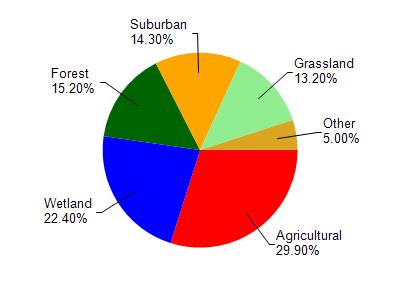
Watershed Characteristics
Nagawicka Lake is located in the Bark River watershed which is 185.84 mi². Land use in the watershed is primarily agricultural (29.90%), wetland (22.40%) and a mix of forest (15.20%) and other uses (32.50%). This watershed has 265.69 stream miles, 3,499.26 lake acres and 22,145.94 wetland acres.
Nonpoint Source Characteristics
This watershed is ranked Medium for runoff impacts on streams, High for runoff impacts on lakes and High for runoff impacts on groundwater and therefore has an overall rank of High. This value can be used in ranking the watershed or individual waterbodies for grant funding under state and county programs.However, all waters are affected by diffuse pollutant sources regardless of initial water quality. Applications for specific runoff projects under state or county grant programs may be pursued. For more information, go to surface water program grants.