Iowa, Lafayette
No
No
Yes
Fish and Aquatic Life
Overview
Mineral Point Branch rises near Dodgeville and flows south to the Pecatonica River. It partially supports a warm water sport fishery, with a portion managed for smallmouth bass. This fishery may be degraded by polluted runoff. A 1990 smallmouth bass survey indicates that the bass fishery in the stream may be affected by whatever factors are causing the decline of the smallmouth bass fishery in southwestern Wisconsin (WDNR, 1992-931). A dam across the stream forms Ludden Lake. We have no information about the effects of that dam on the fishery or water quality below the dam. Two fish species on the state's threatened and endangered species list have been found in this stream, the slender madtom and the Ozark minnow (Fago, 1982).
Date
Author Aquatic Biologist
Overview
This warm water stream begins on the Military Ridge just west of Dodgeville and flows southerly into Lafayette County. A dam across the stream northwest of Mineral Point forms Ludden Lake. We have no information about the effects of the dam of the fishery or water quality below the dam (1995 basin report). Mineral Point Branch is managed as a smallmouth bass fishery and is considered one of the best quality bass fisheries in the region. The DNR Bureau of Research conducts monitoring every year to determine trends in bass populations (Sims). Their data shows a decrease in smallmouth bass population, similar to findings on streams in the region overall. In 2001, hoop net surveys found good populations of channel catfish and redhorse. Walleyes continue to be stocked, but the number of returns on these fish is currently unknown. Two fish species on the state’s threatened and endangered species list, the slender madtom and the Ozark minnow, have been found in this stream (Fago, 1982). There is no more recent evidence to confirm these species still inhabit the stream.
Date 2002
Author Aquatic Biologist
Historical Description
Mineral Point Branch (Bartles) - Mouth location T4N R2E Section 14 -15, Surface area = 35.0 acres, Length = 15.1 miles, Gradient = 18.5 feet per mile, Total alkalinity = 268.0 mg/l, Volume of flow = 8.9 cfs.
Mineral Point Branch is classified as a warmwater seepage stream although there are some springs feeding it. It begins on the Military Ridge just west of Dodgeville and flows southerly into Lafayette County where it meets
the West Branch of the Pecatonica River. Principal tributaries are the East Pecatonica River in Iowa County, and Furnace Creek which begins in Iowa County and enters in Lafayette County. There has been a history of pollution in the form of mine and cheese factory wastes from these tributaries.
Woodlands are scarce in the watershed and about 92 percent of it is farmed intensively, with beef cattle pasture being one of the chief land uses. Flooding is common and bank erosion is severe in most sections. This condition has been alleviated locally to some extent by the construction of a dam and subsequent 70-acre Ludden Lake just west of Mineral Point about midway in its length. The stream sport fishery is predominately smallmouth bass and catfish below Ludden Lake. The panfish present include rock bass. bluegills. green sunfish, black crappies and bullheads. Forage and rough fish found throughout most of its length include white and hogsuckers, hornyhead and creek chubs; suckermouth. bluntnose, and stoneroller minnows; common, rosyface and lake emerald shiners; stonecats, johnny darters, carp, quillback,carpsuckers, redhorse and buffalo. Aquatic game assets are limited because of lack of bank cover, but muskrats are commonly found in the
lower sections and ducks utilize the wider areas during spring and fall migrations. Ludden Lake provides the best wildlife habitat on the stream as well as the only planned public access. There are no public lands along this stream. Presently, it is accessible from six road crossings.
From: Piening, Ronald and Threinen, C.W., 1968. Lake and Stream Classification Project. Surface Water Resources of Iowa County, Wisconsin Department of Natural Resources, Madison, WI.
Date 1968
Author Surface Water Inventory Of Wisconsin
Historical Description
Mineral Point Branch, T3N, R2E, Sections 1-1, Surface acres = 19.1, Miles = 5.1, Gradient = 33.4 feet per mile, Total alkalinity = 264 mg/l, Volume of flow = 17.8 cfs.
As a major tributary of the West Branch of the Pecatonica, Mineral Point Branch is principally a warm water drainage stream. Only 5.5 percent of its total watershed area lies within the county. Furnace Creek is its only named tributary within the county. There is also one unnamed feeder which joins it just south of the county line. Mineral Point Branch provides good habitat for smallmouth bass and channel catfish since there are frequent stretches of deep quiet water with fairly deep pools found throughout its length. Since much of the floodplain is subject to severe flooding during periods of heavy runoff, bank erosion is a serious problem. Fresh meadow and firm pasture are the most prevalent cover types inthe bottoms, with upland hardwood pasture and cropland predominating on the uplands. Streambottom types consist of gravel with some silt near the mouth. Game assets include most upland species common to the county, and some puddle and wood ducks nesting near the mouth. Muskrats are also common. Public access within the county is restricted to two town road bridges since there is no other public land along the stream.
From: Piening, Ronald; Poff, Ronald; Threinen, C.W., 1967. Lake and Stream Classification Project. Surface Water Resources of Lafayette County, Wisconsin Department of Natural Resources, Madison, WI.
Date 1967
Author Surface Water Inventory Of Wisconsin
Impaired Waters
Mineral Point Br (927900) was placed on the impaired waters list for total phosphorus in 2014. The 2016 assessments showed continued impairment by phosphorus; total phosphorus sample data exceeded 2016 WisCALM listing criteria for the Fish and Aquatic Life use, however, available biological data did not indicate impairment (i.e. no macroinvertebrate or fish Index of Biotic Integrity (IBI) scored in the "poor" condition category). Based on the most updated information, no change in existing impaired waters listing is needed.
Date 2015
Author Aaron Larson
Condition
Wisconsin has over 84,000 miles of streams, 15,000 lakes and milllions of acres of wetlands. Assessing the condition of this vast amount of water is challenging. The state's water monitoring program uses a media-based, cross-program approach to analyze water condition. An updated monitoring strategy (2015-2020) is now available. Compliance with Clean Water Act fishable, swimmable standards are located in the Executive Summary of Water Condition in 2018. See also the 'monitoring and projects' tab.
Reports
Recommendations
Partnership Project
DNR should seek opportunities to work collaboratively on projects which would benefit overall ecosystem health. Such opportunities include working with the Southwest Grasslands and Stream Conservation Area and Southwest Grasslands Bird Conservation Area. The department should work with groups to identify areas which would overlap as a priority for these programs, such as the upper Mineral Point watershed. These projects would also benefit Ludden Lake.
Monitor or Propose 303(d) Listing
Ludden Lake should be added to the state�s 303(d) list of impaired waters because levels of total phosphorus and chlorophyll a exceed criteria and thresholds for shallow lowland lakes. The department should seek the aforementioned opportunities to work with partners to decrease soil and nutrient loss in the watershed upstream of Ludden Lake in order to improve water clarity, enhance macrophyte growth, and maintain the depth of the lake system which has been decreased over time due to sediment loads from upstream.
Best Management Practices, Implement
Total phosphorus exceeds the state criteria of 0.075 mg/l and thus Mineral Point Branch will remain on the state�s 303(d) list of impaired waters. The aforementioned nonpoint source best management practices would also help reduce phosphorus delivery to the stream. Fisheries management has several recommendations for Mineral Point Branch: no stocking of fish, maintaining the current size regulations, develop projects which would provide more habitat for smallmouth bass, especially the creation of deep pools and runs to hold adults year round. Below Ludden Lake specifically, fisheries management recommends looking at efforts to secure streambank easements.
Monitor Targeted Watershed Area (TWA)
A Water Quality Plan for SP09 based on monitoring of the contemporary status of this subwatershed (HUC 12) in the Mineral Point Branch watershed. The DNR department collected fish, habitat, macroinvertebrate and water chemistry data for streams in this watershed. The data was used to determine whether these streams are achieving their attainable use to update the watershed tables, list waters are not meeting attainable use, and assess the overall health of the watersheds as required by Section 305(b) of the Clean Water Act. The data, used in conjunction with observations about watershed health, was be used to guide planning for improvements where needed. This subwatershed, and the adjoining subwatersheds that make up the HUC 10 were identified as one of the top group watersheds for nutrient input by the WI Nutrient Reduction Strategy.
Water Quality Planning
Management Goals
Wisconsin's Water Quality Standards provide qualitative and quantitative goals for waters that are protective of Fishable, Swimmable conditions [Learn more]. Waters that do not meet water quality standards are considered impaired and restoration actions are planned and carried out until the water is once again fishable and swimmable
Management goals can include creation or implementation of a Total Maximum Daily Load analysis, a Nine Key Element Plan, or other restoration work, education and outreach and more. If specific recommendations exist for this water, they will be displayed below online.
Monitoring
Monitoring the condition of a river, stream, or lake includes gathering physical, chemical, biological, and habitat data. Comprehensive studies often gather all these parameters in great detail, while lighter assessment events will involve sampling physical, chemical and biological data such as macroinvertebrates. Aquatic macroinvertebrates and fish communities integrate watershed or catchment condition, providing great insight into overall ecosystem health. Chemical and habitat parameters tell researchers more about human induced problems including contaminated runoff, point source dischargers, or habitat issues that foster or limit the potential of aquatic communities to thrive in a given area. Wisconsin's Water Monitoring Strategy was recenty updated.
Grants and Management Projects
Monitoring Projects
| WBIC | Official Waterbody Name | Station ID | Station Name | Earliest Fieldwork Date | Latest Fieldwork Date | View Station | View Data |
|---|
| 927900 | Mineral Point Br | 10042382 | Mineral Point Branch at CTH CH | | | Map | Data |
| 927900 | Mineral Point Br | 10048389 | Mineral Point Branch at Barreltown Bird Conservation Area | 5/21/2017 | 10/18/2024 | Map | Data |
| 927900 | Mineral Point Br | 333207 | Mineral Point Branch - Cth O (Bi) | 5/10/1979 | 10/20/2015 | Map | Data |
| 927900 | Mineral Point Br | 10049078 | Mineral Point Branch - 1600m DS HWY 39 bridge | | | Map | Data |
| 927900 | Mineral Point Br | 10043903 | Mineral Point Branch - Farm Crossing at 0276 Pittz-Schaaf Rd | 1/1/2015 | 10/7/2015 | Map | Data |
| 927900 | Mineral Point Br | 253185 | Mineral Point Branch - (Bridge) - N. Oak Park Rd | 6/30/2003 | 10/20/2015 | Map | Data |
| 927900 | Mineral Point Br | 10043978 | Mineral Point Br - 20 m upstrm of confl. with Pecatonica R | 1/1/2015 | 8/21/2015 | Map | Data |
| 927900 | Mineral Point Br | 253176 | Mineral Point Branch - (Bridge) - N. Oak Park Rd | 6/30/2003 | 10/7/2015 | Map | Data |
| 927900 | Mineral Point Br | 253194 | Mineral Point Branch E of Survey Rd | 6/19/2001 | 10/6/2015 | Map | Data |
| 927900 | Mineral Point Br | 10011862 | Mineral Point Br - 50m Below Hwy 39 Bridge | 10/19/2004 | 10/19/2004 | Map | Data |
| 927900 | Mineral Point Br | 253175 | Mineral Point Branch - Mineral Point Branch | 5/23/2001 | 6/30/2003 | Map | Data |
| 927900 | Mineral Point Br | 253184 | Mineral Point Branch - Mineral Point Branch | 6/30/2003 | 6/30/2003 | Map | Data |
| 927900 | Mineral Point Br | 10028848 | Mineral Point Branch At Oak Park Rd (Near County Line) | 7/23/2008 | 7/31/2015 | Map | Data |
| 927900 | Mineral Point Br | 10011864 | Mineral Point Br - N Oak Park Road Bridge | 10/19/2004 | 10/19/2004 | Map | Data |
| 927900 | Mineral Point Br | 10044948 | Mineral Point Branch - at Highway 151 | 7/10/2016 | 7/10/2016 | Map | Data |
| 927900 | Mineral Point Br | 10043906 | Mineral Point Branch - STH 39 | 1/1/2015 | 7/30/2015 | Map | Data |
| 927900 | Mineral Point Br | 10043802 | Mineral Point Branch at Mill Creek Road | 1/1/2015 | 10/6/2015 | Map | Data |
| 927900 | Mineral Point Br | 10042651 | Mineral Point Br start of State Property off West Bennett Rd | 1/1/2015 | 8/21/2015 | Map | Data |
|
Watershed Characteristics
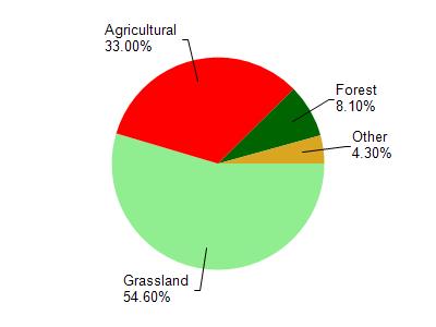
Mineral Point Br is located in the Mineral Point and Sudan Branches watershed which is 108.26 mi². Land use in the watershed is primarily grassland (54.60%), agricultural (33%) and a mix of forest (8.10%) and other uses (4.30%). This watershed has 289.93 stream miles, 87.79 lake acres and 699.78 wetland acres.
Nonpoint Source Characteristics
This watershed is ranked Not Ranked for runoff impacts on streams, Not Ranked for runoff impacts on lakes and High for runoff impacts on groundwater and therefore has an overall rank of High. This value can be used in ranking the watershed or individual waterbodies for grant funding under state and county programs.However, all waters are affected by diffuse pollutant sources regardless of initial water quality. Applications for specific runoff projects under state or county grant programs may be pursued. For more information, go to surface water program grants.