Details
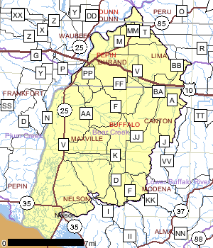
The Bear Creek Watershed covers 176.5 square miles in Buffalo and Pepin counties. Bear, Little Bear, and Spring creeks are the three primary sub-watersheds within the Bear Creek Watershed. The watershed drains rolling agricultural and wooded areas with many of the tributaries originating in steep coulees. The watershed also drains one urban area, the City of Durand. All streams within the Bear Creek Watershed drain the eastern slope of the Chippewa River Valley.
The Bear Creek Watershed contains typical steep topography characteristic of the driftless or un-glaciated area of the state. Because the most productive and level land is on the valley floor, most farming takes place immediately adjacent to streams. Former prairie and a portion of the forested lands have been converted to agricultural uses. The quality of trout streams in this watershed have improved or degraded as agricultural uses have diminished or increased.
Earlier editions of the Lower Chippewa River Water Quality Management Plan indicated the Nelson wastewater treatment plant and Nelson Cheese Factory discharged to the Lower Chippewa Basin. Due to a basin boundary change, both are in the Buffalo-Trempealeau River Basin. The majority of the wetlands in the watershed are adjacent to the Chippewa and Mississippi Rivers.
Date 2011
Population, Land Use
Land use in the Bear Creek Watershed is dominated by forest cover (40%) and agriculture (37%). Wetlands and open water encompass most of the remaining area in the watershed with 15% and six percent, respectively. Grasslands make up a little over one percent of the watershed’s total area, while urban and suburban land use is minimal with one-tenth of a percent and one-half a percent, respectively.
Date 2011
Nonpoint and Point Sources
Little Bear Creek and the North Branch of Little Bear Creek are both ranked as high priority streams for nonpoint source (NPS) pollution and are thus likely to respond to Best Management Practices (BMPs).
Date 2011

Ecological Landscapes
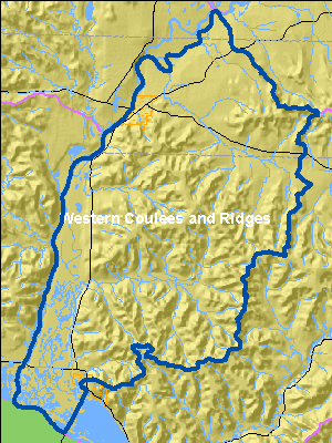
The Western Coulee and Ridges Ecological Landscape in southwestern and west central Wisconsin is characterized by its highly eroded, driftless topography and relatively extensive forested landscape. Soils are silt loams (loess) and sandy loams over sandstone residuum over dolomite. Several large rivers including the Wisconsin, Mississippi, Chippewa, Kickapoo and Black flow through or border the Ecological Landscape.
Historical vegetation consisted of southern hardwood forests, oak savanna, scattered prairies, and floodplain forests and marshes along the major rivers. With Euro-American settlement, most of the land on ridgetops and valley bottoms was cleared of oak savanna, prairie, and level forest for agriculture. The steep slopes between valley bottom and ridgetop, unsuitable for raising crops, grew into oak-dominated forests after the ubiquitous presettlement wildfires were suppressed. Current vegetation is a mix of forest (40%), agriculture, and grassland with some wetlands in the river valleys. The primary forest cover is oak-hickory (51%) dominated by oak species and shagbark hickory. Maple-basswood forests (28%), dominated by sugar maple, basswood and red maple, are common in areas that were not subjected to repeated presettlement wildfires. Bottomland hardwoods (10%) are common in the valley bottoms of major rivers and are dominated by silver maple, ashes, elms, cottonwood, and red maple. Relict conifer forests including white pine, hemlock and yellow birch are a rarer natural community in the cooler, steep, north slope microclimates.
Date 2010
Hydrologic Features
Streams within the Bear Creek Watershed have changed dramatically over the past century. Most streams during pre-settlement conditions likely contained self-sustaining native brook trout fisheries. During the early European settlement period, this region saw some logging for timber production and small dam building from milling operations. Following the logging and mill dam era, in the early and mid 1900’s, intensive agricultural practices and severe flooding degraded stream habitat conditions and the health of the native coldwater fish communities. Flash floods have always been a problem on streams in west central Wisconsin due to the steep topography. Flooding conditions likely still impact stream resources, but they are not considered a main limiting factor because other streams within west central Wisconsin experience similar flood events and support very healthy coldwater fish communities. Within the past decade many streams in western Wisconsin have been improving. Changes in land use practices along with the installation of Best Management Practices (BMPs) in the watershed appear to be aiding in the recovery of coldwater fish communities (Heath M. Benike and Scott W. Peavy. Bear Creek Watershed Comprehensive Surface Water Resource Report Pepin and Buffalo Counties, Wisconsin, January, 2002).
Date 2011
Recreational Opportunities
The Tiffany Bottoms State Wildlife Area, located along the Chippewa River in Buffalo County within the Tiffany Wildlife Area, is only a small portion of the most extensive river delta in the Midwest. Ths area is home to many plant and animal species that require the unique habitat of the floodplain forest for survival. The eastern massasauga rattlesnake, endangered in Wisconsin, is one such species that prefers lowland areas along rivers, lakes and marshes. The portion of the Chippewa River delta south of the railroad tracks is designated as an Upper Mississippi River National Wildlife and Fish Refuge.
Date 1996
River and Stream QualityAll Waters in WatershedAccording to the WDNR’s Register of Waterbodies (ROW) database, there are over 636 miles of streams and rivers in the Bear Creek Watershed; 150 miles of which have been entered into the WDNR’s assessment database. Of these 150 miles, about one-third (31%) are meeting Fish and Aquatic Life uses and are specified as in “good” condition; another 28% of streams are considered to be in “poor” condition and are listed as impaired. The condition of the remaining stream miles is not known or documented.
There are 39 miles of Class II trout streams dispersed over stretches of Center, Bear, the North Branch of Little Bear, Little Bear, Newton Valley (Shoe), and Spring creeks along with a tributary to the North Branch of Little Bear Creek, locally named Owen Valley Creek. A small unnamed creek and Weisenbeck Valley Creek contribute a total of eight miles of Class III trout streams for the watershed. There are no Exceptional or Outstanding Resource Streams or Rivers listed in the Bear Creek Watershed.
As part of the Lower Chippewa Basin Comprehensive Surface Water Resources Monitoring Program, the Bear Creek Watershed was sampled during the 1999 field season. The Bear Creek Watershed comprehensive stream survey was conducted to gather baseline data on fish habitat, sport and nongame fish communities, temperature regimes, and macroinvertebrate communities. From the information that was collected, streams within the Bear Creek Watershed have been improving. Coldwater IBI ratings of excellent were present at sites within each subwatershed. Some streams supported moderate levels of salmonid abundance and reproduction of wild brook trout. Habitat conditions on all streams in the watershed are limited by the absence of coarse substrates and an excessive sand bedload. This is likely due to past land use practices as well as the geological parent material found on the eastern slope of the Chippewa River Valley. Flooding is still a problem on streams within the Bear Creek Watershed but, are not considered a main limiting factor because all streams in west central Wisconsin within and outside the Bear Creek Watershed experience similar flooding and still support healthy coldwater fish communities. Stream habitat restoration activities on select sites could enhance habitat conditions for the coldwater fish community. Future management efforts should consist of modification of salmonid stocking practices, buffer installations, nutrient management, rotational grazing, and possible flood control efforts at select locations in the watershed. With improvements in land use and near shore habitat protection or restoration, it is likely that the overall health of the Bear Creek Watershed can be significantly improved. The following subwatershed details come from the Bear Creek Watershed Comprehensive Surface Water Resource Report Pepin and Buffalo Counties, Wisconsin (Heath M. Benike and Scott W. Peavy. January, 2002).
Date 2011
Watershed Trout StreamsWatershed Outstanding & Exceptional ResourcesLakes and Impoundments
The WDNR’s ROW database shows that there are over 154 acres of lakes and ponds and over 910 acres of other unspecified open water in the Bear Creek Watershed. Of these, approximately 209 acres are entered into the state’s assessment database. No lakes in the watershed have been assessed for fish and aquatic life use or any other use. Browning, Stump, and Duck lakes are the only named lakes in the watershed. Stump and Duck lakes are categorized as shallow seepage lakes. There are no Exceptional or Outstanding Resource Lakes listed in the Bear Creek Watershed.
Date 2011
Wetland Health
Wetland Status
The Bear Creek Watershed is located in northwest Buffalo County and south central Pepin County. An estimated half of the current land uses in the watershed are wetlands. Currently, over 95% of the original wetlands in the watershed are estimated to exist. Of these wetlands, the majority include forested wetlands (46%), and emergent wetlands (34%), which include marshes and wet meadows.
Wetland Restorability
Of the 2,728 acres of estimated lost wetlands in the watershed, only about one-quarter (24%) are considered potentially restorable based on modeled data, including soil types, land use and land cover (Chris Smith, DNR, 2009).
Date 2011
Impaired Waters
About a 38-mile section of the Chippewa River has been listed as impaired by PCBs and mercury since 1998, including a 20-mile stretch that was also listed for high mercury levels. New fish data, collected from 2000 through 2005, suggested removing Mercury Specific Advisory for this stretch of the Chippewa River.
Date 2011
List of Impaired WatersAquatic Invasive Species
No aquatic invasive species have been documented in this watershed.
Date 2011
Fish Consumption Advice
Wisconsin’s fish consumption advisory is based on the work of public health, water quality and fisheries experts from eight Great Lakes states. Based on the best available scientific evidence, these scientists determined how much fish is safe to eat over a lifetime based on the amount of contaminants found in the fish and how those contaminants affect human health. Advisories are based on concentrations of the following contaminants along with angler habits, fishing regulations and other factors.
A fish consumption advisory for polychlorinated biphenyls (PCBs) has been placed on the Chippewa River downstream of the dam at Holcombe to its confluence with the Mississippi River since January of 2010. Pool 4 of the Mississippi River has also had a fish consumption advisory in effect for PCBs and perfluorooctanesulfonic acid (PFOs) since January of 2010.
Studies indicate that people exposed to PCBs are at greater risk for a variety of health problems. Infants and children of women who have eaten a lot of contaminated fish may have lower birth weights and be delayed in physical development and learning. PCBs may affect reproductive function and the immune system and are also associated with cancer risk. Once eaten, PCBs are stored in body fat for many years. Each time you ingest PCBs the total amount of PCB in your body increases (Proposed Guidance For the Classification, Assessment, & Management of Wisconsin Surface Waters, Lowndes & Helmuth, March 12, 2007).
Date 2011
Groundwater
The following groundwater information is for Buffalo and Pepin counties (from Protecting Wisconsin’s Groundwater through Comprehensive Planning website, http://wi.water.usgs.gov/gwcomp/), which roughly approximates to the Bear Creek Watershed.
Durand is the only municipal water system in the Bear Creek Watershed that has a wellhead protection plan or a wellhead protection ordinance. A wellhead protection plan uses public involvement to delineate the wellhead protection area, inventory potential groundwater contamination sources, and manage the wellhead protection area. Buffalo and Pepin counties have both adopted animal waste management ordinances, as well.
From 1979 to 2005, total water use in Buffalo County has increased from approximately 3.0 million gallons per day to 7.3 million gallons per day in 2000, and decreased to five million gallons per day in 2005. The increase by 2000 and decrease in 2005 in total water use over this period is due to irrigation use. The proportion of county water use supplied by groundwater has fluctuated from 98% to 95% over this period.
In Pepin County, total water use has increased from about 1.2 million gallons per day to about 3.0 million gallons per day from 1979 to 2005. The increase in total water use over this period is due primarily to an increase in irrigation use and industrial use after 2000. The proportion of county water use supplied by groundwater has consistently been about 98% during the period 1979 to 2000, and decreased to 55% in 2005.
Private Wells
Ninety percent of 184 private well samples collected in Buffalo County and 81% of 59 private well samples collected in Pepin County from 1990 to 2006 met the health-based drinking water limit for nitrate-nitrogen. Land use affects nitrate concentrations in groundwater. An analysis of over 35,000 Wisconsin drinking water samples found that drinking water from private wells was three times more likely to be unsafe to drink due to high nitrate in agricultural areas than in forested areas. High nitrate levels were also more common in sandy areas where the soil is more permeable. In Wisconsin’s groundwater, 80% of nitrate inputs originate from manure spreading, agricultural fertilizers, and legume cropping systems.
A 2002 study estimated that 52% of private drinking water wells in the region of Wisconsin that includes Buffalo and Pepin counties contained a detectable level of an herbicide or herbicide metabolite. Pesticides occur in groundwater more commonly in agricultural regions, but can occur anywhere pesticides are stored or applied. There are no atrazine prohibition areas in either county.
Potential Sources of Contamination
Two dairy Concentrated Animal Feeding Operations (CAFOs) can be found near Durand, including Weiss Family Farms, Inc., which is part of the Natural Resources Conservation Service’s (NRCS) Conservation Security Program (CSP). To help protect local water and soil quality the Weiss family use several conservation practices on their farm, including contouring planting, nutrient and pest management, grass waterways, and crop rotations. No licensed landfills or Superfund sites are located within the watershed.
Date 2011

Goals
1/6/2012
Update trout angling regulations to category four waters to protect brook trout fisheries
1/6/2012
Identify water quality or habitat threats to protect rare species
1/6/2012
Encourage best management practices and buffer zones to decrease erosion.
Priorities
1/6/2012
Low trout densities
1/6/2012
Rare species populations have been declining in the Chippewa River
1/6/2012
Stream habitat hindrance due to lack of coarse substrate and excessive sand bedload.
Watershed RecommendationsBuffalo County Feed Storage
Date
Status
This project is a landowner installation of nonpoint source best management practices to contribute to the restoration of Wisconsin?s waters and was funded by the 319 grant. The grantee will implement practices to address agricultural nonpoint sources of pollution through the installation of Best Management Practices (BMPs) addressing sediment and nutrient loading and violations of the NR 151 Agricultural Performance Standards and Prohibitions. Specifically, the grantee will implement: access roads and cattle crossings; and a feed storage runoff control system.
1/1/2018
In Progress
Buffalo County Manure Storage
Date
Status
This project is a landowner installation of nonpoint source best management practices to contribute to the restoration of Wisconsin's waters and was funded by the 319 grant. The grantee will implement practices to address agricultural nonpoint sources of pollution through the installation of Best Management Practices (BMPs) addressing sediment and nutrient loading and violations of the NR 151 Agricultural Performance Standards and Prohibitions. Specifically, the grantee will implement: a waste transfer system; a barnyard runoff control system; animal trails and walkways; and animal trails and walkways critical area stabilization.
1/1/2018
In Progress
Buffalo County Manure Management
Date
Status
This project is a landowner installation of nonpoint source best management practices to contribute to the restoration of Wisconsin's waters and was funded by the 319 grant. Specifically, the grantee will implement: a manure storage system to address the following NR 151 Agricultural Performance Standards and Prohibitions:manure storage facilities-new/significant alterations, process wastewater handling, prevention of unconfined manure piles in water quality management, and prevention of direct runoff from a feedlot or stored manure into waters of the state.
1/1/2017
In Progress
Buffalo County Barnyard Feedlot
Date
Status
This project is a landowner installation of nonpoint source best management practices to contribute to the restoration of Wisconsin's waters and was funded by the 319 grant. Specifically, the grantee will implement: a barnyard runoff control system, critical area stabilization, and diversions to address the NR 151 Agricultural Performance Standards and Prohibitions.
1/1/2017
In Progress
Confirm FCA: IW pre-2000 data
Date
Status
2050000 name Chippewa River TMDL ID 80 Start Mile 20.73 End Mile 37.58
11/21/2011
Proposed
Monitor Cascade Valley Ck. to L. Bear Creek for fish/bugs
Date
Status
Other sites in watershed indicate good biological data. This site is near a bad barnyard, and may not be representative of entire stream. Further investigation needed.
8/21/2019
Proposed
Chippewa River TP
Date
Status
Removed TP listing recommendation. Further sampling will be taken to make an assessment decision. AU: 18765; Station ID: 473008
5/1/2018
Proposed
Waumandee TMDL
Date
Status
The Waumandee Creek Watershed is located in Buffalo County, Wisconsin. The Waumandee Creek Watershed drains 204 square miles and is characterized by steep topography, narrow valleys and numerous streams.Surface water drains to the Mississippi River by direct runoff or via Waumandee Creek and its tributaries. Temperature and sediment impairments are found in Buell Valley Creek, Cochrane Ditch (Rose Valley), Irish Valley Creek, Jahns Valley Creek, Weiland Valley Creek. Coverage of the substrates with sediment constitutes ?an objectionable deposit? under the water quality standards criterion noted in S.NR 102.04(1) (a) cited below. The creeks are limited by excessive sediment loading and habitat unsuitable to support a coldwater fishery.
3/1/2006
In Progress
Bear Creek Watershed Planning
Date
Status
The Bear Creek Watershed covers 76.5 square miles in Buffalo and Pepin counties. Bear, Little Bear, and Spring creeks are the three primary sub-watersheds within the Bear Creek Watershed. The watershed drains rolling agricultural and wooded areas with many of the tributaries originating in steep coulees. The watershed also drains one urban area, the City of Durand. All streams within the Bear Creek Watershed drain the eastern slope of the Chippewa River Valley. The Bear Creek Watershed contains typical steep topography characteristic of the driftless or un-glaciated area of the state. Because the most productive and level land is on the valley floor, most farming takes place immediately adjacent to streams. Former prairie and a portion of the forested lands have been converted to agricultural uses. The quality of trout streams in this watershed have improved or degraded as agricultural uses have diminished or increased. Earlier editions of the Lower Chippewa River Water Quality Management Plan indicated the Nelson wastewater treatment plant and Nelson Cheese actory discharged to the Lower Chippewa Basin. Due to a basin oundary change, both are in the Buffalo- Trempealeau River Basin. The majority of the wetlands in the watershed are adjacent to the Chippewa and Mississippi Rivers.
7/1/2010
In Progress
 Water Plans and PartnershipsRead the Watershed Plan
The plan for watershed has been updated in 2011 and is available for public comment through February 6th, 2012.
Date 2011
Watershed History NoteOriginally named Bear Creek, the City of Durand is located on the banks of the Chippewa River approximately 15 miles from its confluence with the Mississippi River, in the Bear Creek Watershed.
The Durand area was first settled in 1856 when 21-year old Miles Durand Prindle came up the river in a keel boat named the "Dutch Lady", and took government land on the site of the present city. Durand was incorporated on April 12, 1887.
In 1873-74, the Old Courthouse building was constructed for the cost of $7000. It served as the Pepin County Courthouse until 1985, except for the years 1882-1886. It and the jail next door are listed on the State and National Registers of Historic Places.
Date 2010