Details
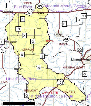
The Upper West Branch Pecatonica River watershed is in southwestern Iowa and northwestern Lafayette counties. The principal land use in the watershed is agricultural, dominated by row crop cultivation. The watershed ranks high for non-point pollution control.
Two small municipalities discharge to surface water in the watershed. The population is not expected to grow significantly over the next 20 years in this predominantly rural area. The First Capitol State Park lies in the extreme southwestern end of the watershed.
Date 2002

Ecological Landscapes
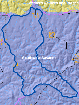
The Southwest Savanna Ecological Landscape is located in the far southwestern part of the state. It is characterized by deeply dissected topography, unglaciated for the last 2.4 million years, with broad open hilltops and river valleys, and steep wooded slopes. The climate is favorable for agriculture but the steep slopes limit it to the hilltops and valley bottoms. Soils are underlain with calcareous bedrock. Soils on hilltops are silty loams, sometimes of shallow depth over exposed bedrock and stony red clay subsoil. Some valley soils are alluvial sands, loams, and peats. Some hilltops are almost treeless due to the thin soil while others have a deep silt loam cap.
Historic vegetation consisted of tall prairie grasses and forbs with oak savannas and some wooded slopes of oak. Almost three-quarters of the current vegetation is agricultural crops with lesser amounts of grasslands, barrens, and urban areas. The major forest types are oak-hickory and maple-basswood. High-quality prairie remnants occur on rocky hilltops and slopes that are not farmed. Some prairie pastures and oak savannas still exist. The grassland areas harbor many rare grassland birds, invertebrates, and other grassland species. Relict stands of pine occur on bedrock outcroppings along some stream systems.
Date 2010
River and Stream QualityAll Waters in WatershedLivingston Branch is on the list of impaired waters due to problems with dissolved oxygen and ammonia. The stream has suffered from periodic fish kills due to runoff from fields and manure management problems (Schlesser, 2001).
A Priority Watershed Project was conducted in this watershed from 1982 to 1992. The DNR completed a nonpoint source evaluation monitoring of sites in the watershed and concluded that the best management practices installed during the project were effective in reducing agricultural nonpoint source pollution, however, overall lack of participation limited water quality benefits.
A detailed report of the evaluation monitoring effort, Upper West Branch Pecatonica River Priority Watershed Project: Bioassessment Final Report, is available through the Bureau of Watershed Management.
Date 2002
Watershed Trout StreamsWatershed Outstanding & Exceptional ResourcesLakes and Impoundments
Impaired Waters
List of Impaired Waters Monitoring & ProjectsProjects including grants, restoration work and studies shown below have occurred in this watershed. Click the links below to read through the text. While these are not an exhaustive list of activities, they provide insight into the management activities happening in this watershed.
Watershed RecommendationsSnowden (Big Patch) Branch TMDL
Date
Status
The sediment TMDL was approved September 12, 2006.
5/1/2010
In Progress
Otter Creek (1237100) TMDL
Date
Status
Otter Creek is impaired due to degraded habitat because of excessive sediment loading from surrounding agricultural lands to the Creek. Otter Creek is currently not meeting the applicable narrative water quality standard (WQS) that prohibits objectionable deposits on the shore or in the bed of a water in amounts that interfere with public rights in the water. To address the degraded habitat impairments, Wisconsin Department of Natural Resources (WDNR) determined that sediment, specifically TSS, is the pollutant that must be addressed to attain designated uses and meet WQS.
9/22/2012
In Progress
ARRA 11 Lafayette Co. TMDL Planning Grant
Date
Status
Contract for county staff to conduct on-site assessments in the Silver Spring, Cherry Branch, and Apple Branch sub-watersheds to develop TMDLs for these impaired waters.
12/7/2009
In Progress
Castle Rock & Gunderson Creek TMDL
Date
Status
The Castle Rock and Gunderson Creek TMDL was created to address phosphorus, sediment, and for at least one creek biological oxygen demand. The TMDL was approved and is in implementation through projects funded by the Clean Water Act Section 319 Program.
6/28/2004
In Progress
Dougherty Creek TMDL
Date
Status
Monitor impaired portion of creek for D.O., nutrients, and BOD to determine level of impairment. Fisheries IBI conducted to determine contemporary status of stream. Sondes, conduct monthly nutrient analysis (12) and event sampling (10). Conduct watershed assessment to determine sources. Conduct macroinverterbrate analysis at 3 sites. July 06-June 07 Upper 4 miles of Dougherty Creek
7/1/2006
In Progress
 Watershed History Note
The present day Village of Cobb, in the Upper West Branch Pecatonica River Watershed, began in 1847 when John Meeker and E.R. Pritchett purchased 880 acres of prairie from the government at $3.00 per acre.
This area was known by various names before the final decision was made permanent. The first name to be given to the area was "Cross Plains", which was also the name of a local inn where travelers who traveled the stage road could stop for food and shelter. The inn did a thriving business as it was the only inn for miles around.
After a period of time, the area was renamed "Danville", after Daniel Zimmer, one of the large landowners in the area. Because of the area's natural agricultural resources, it was acclaimed the garden spot of Iowa County and was next designated "Village of Eden".
General Amoss Cobb, lawyer by profession and District Attorney of Iowa County, eventually becoming state senator, made frequent visits to the village professionally and otherwise. Because of his dynamic personality, he captivated the esteem and respect of the citizens and they in turn, renamed the village "Cobb".
Date 2011