Portage
No
No
Yes
Fish and Aquatic Life
Overview
Mill Creek is a 47-mile tributary of the Wisconsin River. The stream originates in the City of Marshfield and has minimal streamflow in the upper reaches. The Marshfield WWTP discharges to the headwaters of Mill Creek and contributes more than 90% of the streamflow at the point of discharge. The upper 14 miles of the stream is listed in NR 104 as a Limited Aquatic Life variance stream and the lower 33 miles is classified as Fish and Aquatic life waters. Mill Creek is also listed as an impaired waterbody on EPA’s 303d list for low dissolved oxygen, which required the Department to develop a TMDL for the stream. The stream is impacted by stormwater run-off from Marshfield, sedimentation, barnyard and cropland run-off, flashy streamflow, channel ditching, streambank erosion, ammonia toxicity and nutrient enrichment. Large volumes of stormwater scours streambeds, erode streamsbanks, and carries sediment, nutrients, and other pollutants to surface waters. August 2000 HBI results suggest there is a significant organic loading to the stream. Water samples collected in the winter of 2000 (before the new treatment plant was built) found ammonia concentrations high enough to cause chronic toxicity to aquatic life based on EPA criteria. Since Mill Creek is currently classified as Limited Aquatic Life, the WWTP in Marshfield has no ammonia limit.
In-stream nitrate values have been as high as 3.0 ppm. Mill Creek is affected by animal waste run-off, particularly in the lower sections of the watershed; livestock density is high in this area (Victor, 1986). Multiple point source discharges to Mill Creek occur in the upper one half of the watershed
Date 2002
Author Aquatic Biologist
Historical Description
Biotic index Sam ling shows water quality is poor to very oor don sections of Mill Creek. In stream nitrate values have been as high as 3.0 ppm. Mill Creek is affected by animal waste runoff, particularly in the lower sections of the watershed and livestock density is high in this area (Victor). Multiple point source discharges to Mill Creek occur in the upper one half o f the watershed.
Date 1991
Author Aquatic Biologist
Impaired Waters
Mill Creek, from its mouth to tributary from Junction City. (miles 0 to 16.01) was added to the Impaired Waters List for phosphorus and low dissolved oxygen in the 1998 assessment cycle. This segment was evaluated every two-year cycle from 2012 to 2022; high phosphorus levels were confirmed. This stream is part of the Wisconsin TMDL, approved in 2019, putting these listings on the Restoration Waters List.
Mill Creek, from tributary from Junction City to tributary just east of CTH K (miles 16.01 to 32.82) was listed for phosphorus and low dissolved oxygen in the 1998 cycle. Evaluation in the 2022 cycle confirmed the phosphorus listing. This water is part of the Wisconsin River TMDL, approved in 2019, putting these listings on the Restoration Waters List.
Mill Creek, from just east of CTH K to its headwaters (miles 32.82 to 46.13) was evaluated in 2016, 2018, and 2022; chloride and bacteria samples indicated a healthy system. This stream is on the Healthy Waters List.
Date 2022
Author Ashley Beranek
Condition
Wisconsin has over 84,000 miles of streams, 15,000 lakes and milllions of acres of wetlands. Assessing the condition of this vast amount of water is challenging. The state's water monitoring program uses a media-based, cross-program approach to analyze water condition. An updated monitoring strategy (2015-2020) is now available. Compliance with Clean Water Act fishable, swimmable standards are located in the Executive Summary of Water Condition in 2018. See also the 'monitoring and projects' tab.
Reports
Recommendations
Educate and engage residents
Golden Sands RC&D seeks to enhance public understanding and appreciation for Mill Creek in Wood and Portage counties by enhancing the organizational capacity of the Friends of Mill Creek. Major project elements to include: 1) river clean-up, 2) field day/tour, 3) streambank restoration project, 4) citizen based stream monitoring program, 5) physical inventory of Mill Creek.
Watershed Mapping or Assessment
The Mill Creek Watershed is located in Portage and Wood Counties. It covers approximately 32548 acres, starting in the city of Marshfield and flowing east/southeast toward Stevens Point for approximately 35 miles. The goals of the RC&D Council for this project include the following: 1.Establish Mill Creek Citizens group as a nonprofit 501(c)(3) organization 2. Develop education resources for Mill Creek- Write and distribute a regular newsletter. 3.Assist in Watershed Resource Inventory 4.Recruit and train a leadership committee 5. Conduct tributary water sampling 6. Develop GIS maps to assist committee.
TMDL Development
Mill Creek is a 47-mile tributary of the Wisconsin River.Mill Creek is also listed as an impaired waterbody on EPA?s 303d list for low dissolved oxygen, which required the Department to develop a TMDL for the stream.
TMDL Development
Mill Creek is a 47-mile tributary of the Wisconsin River. Mill Creek is also listed as an impaired waterbody on EPAs 303d list for low dissolved oxygen, which required the Department to develop a TMDL for the stream.
Management Goals
Wisconsin's Water Quality Standards provide qualitative and quantitative goals for waters that are protective of Fishable, Swimmable conditions [Learn more]. Waters that do not meet water quality standards are considered impaired and restoration actions are planned and carried out until the water is once again fishable and swimmable
Management goals can include creation or implementation of a Total Maximum Daily Load analysis, a Nine Key Element Plan, or other restoration work, education and outreach and more. If specific recommendations exist for this water, they will be displayed below online.
Monitoring
Monitoring the condition of a river, stream, or lake includes gathering physical, chemical, biological, and habitat data. Comprehensive studies often gather all these parameters in great detail, while lighter assessment events will involve sampling physical, chemical and biological data such as macroinvertebrates. Aquatic macroinvertebrates and fish communities integrate watershed or catchment condition, providing great insight into overall ecosystem health. Chemical and habitat parameters tell researchers more about human induced problems including contaminated runoff, point source dischargers, or habitat issues that foster or limit the potential of aquatic communities to thrive in a given area. Wisconsin's Water Monitoring Strategy was recenty updated.
Grants and Management Projects
Monitoring Projects
| WBIC | Official Waterbody Name | Station ID | Station Name | Earliest Fieldwork Date | Latest Fieldwork Date | View Station | View Data |
|---|
| 1398600 | Mill Creek | 503157 | Mill Creek - Green Meadow Rd. | 8/21/2001 | 8/21/2001 | Map | Data |
| 1398600 | Mill Creek | 503064 | Wisconsin River at Mouth Of Bear Creek | 3/24/1976 | 3/24/1976 | Map | Data |
| 1398600 | Mill Creek | 10036062 | Mill Creek - Area of Open Water | | | Map | Data |
| 1398600 | Mill Creek | 10051390 | Mill Creek at CTH C | 8/14/2018 | 10/22/2018 | Map | Data |
| 1398600 | Mill Creek | 723289 | Mill Creek - Mill Creek Lane | 6/20/2002 | 6/20/2002 | Map | Data |
| 1398600 | Mill Creek | 10036159 | Mill Creek - Area of Open Water | | | Map | Data |
| 1398600 | Mill Creek | 10009455 | Mill Creek At Cth P - Station 6 | 10/18/2000 | 10/18/2000 | Map | Data |
| 1398600 | Mill Creek | 10052186 | Mill Creek at Robin Road | 5/20/2019 | 5/4/2022 | Map | Data |
| 1398600 | Mill Creek | 503072 | Mill Creek at Cth P | 5/1/1979 | 1/23/2001 | Map | Data |
| 1398600 | Mill Creek | 503156 | Mill Creek - Maple Rd. | 8/21/2001 | 8/21/2001 | Map | Data |
| 1179900 | Wisconsin River | 10007538 | Biron Flowage | 9/8/1994 | 9/30/2017 | Map | Data |
| 1398600 | Mill Creek | 10036796 | Mill Creek - Area of Open Water | | | Map | Data |
| 1398600 | Mill Creek | 10012666 | Mill Creek at CTH PP bridge | 9/3/2004 | 5/4/2022 | Map | Data |
| 1398600 | Mill Creek | 10032102 | Mill Creek at CTH M #842 | 12/2/2010 | 10/7/2021 | Map | Data |
| 1398600 | Mill Creek | 10009453 | Mill Creek At Cth M - Station 5 | 1/27/2000 | 9/20/2016 | Map | Data |
| 1398600 | Mill Creek | 10016112 | Mill Creek at Graham property 3/4 mile upstream from CTH M | 10/11/2004 | 10/25/2006 | Map | Data |
| 1398600 | Mill Creek | 10036158 | Mill Creek - Area of Open Water | | | Map | Data |
| 1398600 | Mill Creek | 503155 | Mill Creek US Elm Rd | 8/21/2001 | 8/17/2005 | Map | Data |
| 1396900 | Biron Flowage | 10007538 | Biron Flowage | 9/8/1994 | 9/30/2017 | Map | Data |
| 1398600 | Mill Creek | 503022 | Mill Creek at Cth O | 9/8/1975 | 5/4/2022 | Map | Data |
|
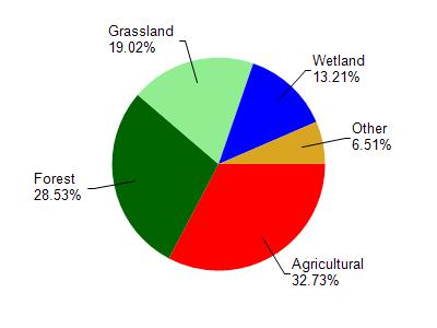
Watershed Characteristics
Mill Creek is located in the Mill Creek watershed which is 166.85 mi². Land use in the watershed is primarily agricultural (32.70%), forest (28.50%) and a mix of grassland (19%) and other uses (19.70%). This watershed has stream miles, lake acres and 22,403.58 wetland acres.
Nonpoint Source Characteristics
This watershed is ranked High for runoff impacts on streams, Low for runoff impacts on lakes and High for runoff impacts on groundwater and therefore has an overall rank of High. This value can be used in ranking the watershed or individual waterbodies for grant funding under state and county programs.However, all waters are affected by diffuse pollutant sources regardless of initial water quality. Applications for specific runoff projects under state or county grant programs may be pursued. For more information, go to surface water program grants.