Manitowoc, Sheboygan
No
No
No
Fish and Aquatic Life
Overview
PIGEON RIVER - OVERVIEW
T15N R23E Sec. 18 Stream Length = 30.0 miles
The Pigeon River originates from a spring fed tributary in an area dominated by wetlands and woodlots in southern Manitowoc County. The Pigeon River flows south into Sheboygan County, through Howards Grove and then turn east to a confluence with Lake Michigan on the north side of Sheboygan. The land use is dominated by agricultural uses, with urban influences in Howards Grove and near the mouth of the river in Sheboygan.
PIGEON RIVER DOWNSTREAM OF THE CONFLUENCE WITH MEEME RIVER (RM 0-18.1)
Water quality in this reach, which extends from the mouth to the confluence with the Meeme River, is fair. Agriculture is the dominant land use in the areas upstream of Howards Grove and watershed becomes increasingly urbanized downstream to the city of Sheboygan. The fishery consists of northern pike, rock bass, black crappie, common shiner, bluntnose minnow, blacknose dace, longnose dace, creek chub, and white sucker (Fago, 1985). Trout and salmon from Lake Michigan are also found in the stream during their seasonal spawning runs.
Macroinvertebrate samples collected during 1996 had HBI ratings indicating fair water quality. The stream has been historically channelized in the agricultural areas, but currently has a fairly good stream buffer in many sections. The problems in this river reach include barnyard runoff, cropland runoff, stream bank pasturing, construction site erosion, streambank erosion, stormwater runoff, and point source effluent.
WDNR personnel surveyed two sites on this reach of the Pigeon River in July 2000. The first site was located upstram of State Highway 42 in the Village of Howards Grove and the second site was within the boundaries of the Maywood Environmental Park in the City of Sheboygan. The Howards Grove site is within a residential area and the Maywood site is within a natural park cooridor that consists of woods and wetlands.
Fish communities rated excellent for both the Howards Grove and Maywood sites. Fish species are listed in Table 61. Stream habitat analysis for the Howards Grove site showed limited streambank erosion; moderate buffer areas and limited shading; bottom substrate of mainly sand and gravel; and limited fish cover. Habitat improvements in this area would improve the fish cover and abundance of fish. The WDNR did install LUNKER type fish habitat structures at this site and is described in more detail below. Stream habitat analysis for the Maywood site showed limited streambank erosion; excellent buffer areas and limited shading; bottom substrate of rock, gravel, and sand; and good fish cover.
Date 2001
Author Aquatic Biologist
Overview
Pigeon River Watershed Mussel Distribution Surveys
Qualitative mussel surveys were conducted in 1997 throughout the Pigeon River Watershed using both the inventory method and incremental collection method. The inventory method was conducted at nearly all bridge crossings and varies from brief collection efforts to one-hour surveys. The incremental collection method was conducted at eleven sights longitudinally from the headwater reaches down to near the mouth of the river. The incremental collection method for mussels is done by collecting a specific number of mussels after the last "new" species is collected. For example, twenty mussels were collected during a sample run, then those are identified. Sampling runs would continue until 100 mussels are collected without identifying a species that had not already been collected. Live mussels were collected by hand, identified and returned to the stream. Dead mussels (i.e. relict shells) were collected of species from which live organisms weren't found. Live environmentally sensitive mussel species (Endangered, Threatened or Special Concern) were measured and aged then returned. Furthermore, a reference collection of shells was made to be used for educational benefits and to aid in future mussel identifications. The non-environmentally sensitive mussel species collected at each incremental collection site are identified below. Two environmentally sensitive species were collected in the Pigeon River watershed as part of the incremental and inventory collections. The locations of these collections are reported by subwatershed (Table 75).
The mussel survey was determined to be very useful for assessing the overall water quality by involving another aquatic organism that is relatively immobile, long-lived, and dependent on host species. Furthermore, it is beneficial to identify unique resources that have existing populations of environmentally sensitive species. Based on the experience of the mussel surveys conducted as part of the Pigeon River IEM project (WDNR 1999), mussel surveys are being incorporated into our "routine" water quality monitoring to the extent possible (pers. comm.Galarneau).
Date 2001
Author Aquatic Biologist
Overview
Installation of Streambank Stabilization Structures
The purpose of this project is to control streambank erosion and develop fish habitat in selected sections of the Pigeon River (Nelson 1998b). The Pigeon River is a warmwater fishery stream that also receives seasonal runs of anadromous fish from Lake Michigan. The fish include salmonids, northern pike, white suckers and longnose suckers. The watershed has been identified as a priority watershed that will be funded in 1998 and beyond. Streambank erosion is severe at the two proposed sites. At the Farmer’s and Sportsman’s Club site alone, 325 feet of eroding bank loses 53.4 tons of soil each year. Fish habitat is poor due to the eroding banks.
During the summer of 1998, we plan to install LUNKER type fish habitat structures, place rip rap and grade banks to eliminate these erosion sources and to provide bank cover. We plan to install at least 325 feet of structure at the Farmer’s and Sportsman’s Club and at least 500 feet of structures at Howard’s Grove municipal park. This work will take place during the growing season (May 1st to September 15th) in 1999 so vegetation becomes established on graded banks. These sites will be accessible to the public and will receive heavy fishing use. Erosion control will be very significant as demonstrated at a downstream site on the Pigeon River where such work was completed several years before.
PIGEON RIVER UPSTREAM OF THE CONFLUENCE WITH MEEME RIVER (RM 18.1-30.0)
This segment extends from the Meeme River confluence upstream to the headwaters area. Agricultural pollution is the major limiting factor in this segment. The stream is flashy because of the extensive wetland drainage and channel modification. The only point source discharging to this segment is the Howards Grove wastewater treatment plant.
Water quality is characterized as fair. There is good diversity of fish species for a headwaters reach, which indicates that a good variety of habitat exists in this segment. The fish species include common shiner, creek chub, white sucker, central mudminnow, fathead minnow, blacknose dace, longnose dace, pearl dace, black bullhead, black crappie, bluegill, green sunfish, johnny darter, sand shiner, brook stickleback and largemouth bass (Aartila 1997). Macroinvertebrate samples collected in 1996 have HBI ratings that indicate good to fair water quality rating. Cropland and barnyard runoff, bank erosion, channelization and wetland drainage are limiting the Pigeon River water quality in this reach (Aartila 1997).
Date 2001
Author Aquatic Biologist
Overview
PIGEON RIVER - OVERVIEW - T15N R23E Sec. 18, Stream Length = 30.0 miles.
The Pigeon River originates from a spring fed tributary in an area dominated by wetlands and woodlots in southern Manitowoc County. The Pigeon River flows south into Sheboygan County, through Howards Grove and then turn east to a confluence with Lake Michigan on the north side of Sheboygan. The land use is dominated by agricultural uses, with urban influences in Howards Grove and near the mouth of the river in Sheboygan.
PIGEON RIVER DOWNSTREAM OF THE CONFLUENCE WITH MEEME RIVER (RM 0-18.1) - Water quality in this reach, which extends from the mouth to the confluence with the Meeme River, is fair. Agriculture is the dominant land use in the areas upstream of Howards Grove and watershed becomes increasingly urbanized downstream to the city of Sheboygan. The fishery consists of northern pike, rock bass, black crappie, common shiner, bluntnose minnow, blacknose dace, longnose dace, creek chub, and white sucker (Fago, 1985). Trout and salmon from Lake Michigan are also found in the stream during their seasonal spawning runs.
Macroinvertebrate samples collected during 1996 had Hilsenhoff Biotic Index (HBI) ratings indicating fair water quality. The stream has been historically channelized in the agricultural areas, but currently has a fairly good stream buffer in many sections. The problems in this river reach include barnyard runoff, cropland runoff, stream bank pasturing, construction site erosion, streambank erosion, stormwater runoff, and point source effluent.
Installation of Streambank Stabilization Structures - The purpose of this project is to control streambank erosion and develop fish habitat in selected sections of the Pigeon River (Nelson 1998b). The Pigeon River is a warmwater fishery stream that also receives seasonal runs of anadromous fish from Lake Michigan. The fish include salmonids, northern pike, white suckers and longnose suckers. The watershed has been identified as a priority watershed that will be funded in 1998 and beyond. Streambank erosion is severe at the two proposed sites. At the Farmer’s and Sportsman’s Club site alone, 325 feet of eroding bank loses 53.4 tons of soil each year. Fish habitat is poor due to the eroding banks.
During the summer of 1998, we plan to install LUNKER type fish habitat structures, place rip rap and grade banks to eliminate these erosion sources and to provide bank cover. We plan to install at least 325 feet of structure at the Farmer’s and Sportsman’s Club and at least 500 feet of structures at Howard’s Grove municipal park. This work will take place during the growing season (May 1st to September 15th) in 1999 so vegetation becomes established on graded banks. These sites will be accessible to the public and will receive heavy fishing use. Erosion control will be very significant as demonstrated at a downstream site on the Pigeon River where such work was completed several years before.
From: Galarneau, Steve and Masterson, John. 1999. Water Resources of the Sheboygan River Basin. Wisconsin Department of Natural Resources, Madison, WI.
Date 1999
Author Aquatic Biologist
Overview
PIGEON RIVER UPSTREAM OF THE CONFLUENCE WITH MEEME RIVER (RM 18.1-30.0) - This segment extends from the Meeme River confluence upstream to the headwaters area. Agricultural pollution is the major limiting factor in this segment. The stream is flashy because of the extensive wetland drainage and channel modification. The only point source discharging to this segment is the Howards Grove wastewater treatment plant.
Water quality is characterized as fair. There is good diversity of fish species for a headwaters reach, which indicates that a good variety of habitat exists in this segment. The fish species include common shiner, creek chub, white sucker, central mudminnow, fathead minnow, blacknose dace, longnose dace, pearl dace, black bullhead, black crappie, bluegill, green sunfish, johnny darter, sand shiner, brook stickleback and largemouth bass (Aartila 1997). Macroinvertebrate samples collected in 1996 have Hilsenhoff Biotic Index (HBI) ratings that indicate good to fair water quality rating. Cropland and barnyard runoff, bank erosion, channelization and wetland drainage are limiting the Pigeon River water quality in this reach (Aartila 1997).
Pigeon River Watershed Mussel Distribution Surveys - Qualitative mussel surveys were conducted in 1997 throughout the Pigeon River Watershed using both the inventory method and incremental collection method. Live mussels were collected by hand, identified and returned to the stream. Dead mussels (i.e. relict shells) were collected of species from which live organisms weren't found. Live environmentally sensitive mussel species (Endangered, Threatened or Special Concern) were measured and aged then returned. Furthermore, a reference collection of shells was made to be used for educational benefits and to aid in future mussel identifications. Two environmentally sensitive species were collected in the Pigeon River watershed as part of the incremental and inventory collections.
The mussel survey was determined to be very useful for assessing the overall water quality by involving another aquatic organism that is relatively immobile, long-lived, and dependent on host species. Furthermore, it is beneficial to identify unique resources that have existing populations of environmentally sensitive species. Based on the experience of the mussel surveys conducted as part of the Pigeon River IEM project (WDNR 1999), mussel surveys are being incorporated into our "routine" water quality monitoring to the extent possible (pers. comm.Galarneau).
From: Galarneau, Steve and Masterson, John. 1999. Water Resources of the Sheboygan River Basin. Wisconsin Department of Natural Resources, Madison, WI.
Date 1999
Author Aquatic Biologist
Recommendations
Citizen-Based Stream Monitoring
Collect chemical, physical, and/or biological water quality data to assess the current overall stream health. The data can inform management decisions and may be used to identify impaired waters for biennial lists.
Educate and engage residents
This grant is for the "Testing the Waters" program that is coordinated by the Sheboygan School District. The purpose of the project is to involve high school students in collection and analyzing water quality data from several stream locations within the Sheboygan River Basin. Students and teachers learn important lessons about river ecology and impacts of pollution as part of this project. The goal of this organization is to assist the "Testing the Waters" Program and as a result enhance the membership and organizational effectiveness of their River Management Organization. Teachers and students will interpret and report water quality datat ata an annual public forum. The grant will help fund the program for three years.
Engage Volunteers in Monitoring/Restoration
Water quality biologists should continue to work with the Pigeon River Water Action Volunteers in conducting water quality monitoring throughout the Pigeon River Watershed.
Monitor to Evaluate Projects
Conduct monitoring on the Pigeon River to determine if it should be listed on the Impaired Waters List
Management Goals
Wisconsin's Water Quality Standards provide qualitative and quantitative goals for waters that are protective of Fishable, Swimmable conditions [Learn more]. Waters that do not meet water quality standards are considered impaired and restoration actions are planned and carried out until the water is once again fishable and swimmable
Management goals can include creation or implementation of a Total Maximum Daily Load analysis, a Nine Key Element Plan, or other restoration work, education and outreach and more. If specific recommendations exist for this water, they will be displayed below online.
Monitoring
Monitoring the condition of a river, stream, or lake includes gathering physical, chemical, biological, and habitat data. Comprehensive studies often gather all these parameters in great detail, while lighter assessment events will involve sampling physical, chemical and biological data such as macroinvertebrates. Aquatic macroinvertebrates and fish communities integrate watershed or catchment condition, providing great insight into overall ecosystem health. Chemical and habitat parameters tell researchers more about human induced problems including contaminated runoff, point source dischargers, or habitat issues that foster or limit the potential of aquatic communities to thrive in a given area. Wisconsin's Water Monitoring Strategy was recenty updated.
Grants and Management Projects
Monitoring Projects
| WBIC | Official Waterbody Name | Station ID | Station Name | Earliest Fieldwork Date | Latest Fieldwork Date | View Station | View Data |
|---|
| 62300 | Pigeon River | 603284 | Pigeon River at County Line Rd Bi | 5/21/1980 | 10/6/1980 | Map | Data |
| 62300 | Pigeon River | 363221 | Pigeon River at Cth M (Bi Sur) | 5/21/1980 | 5/23/2001 | Map | Data |
| 62300 | Pigeon River | 603420 | Pigeon River at County Line Road | 6/16/1993 | 10/18/2022 | Map | Data |
| 62300 | Pigeon River | 363271 | Pigeon River at Pigeon R Rd Pr1 | 3/28/1994 | 6/22/2000 | Map | Data |
| 62300 | Pigeon River | 10010638 | Pigeon River | | | Map | Data |
| 62300 | Pigeon River | 10016696 | Pigeon River - Downstream Of South Cleveland Rdapproximately 100 Yards | 5/1/1996 | 1/1/2015 | Map | Data |
| 62300 | Pigeon River | 10010639 | Pigeon River | | | Map | Data |
| 62300 | Pigeon River | 10040567 | Pigeon Creek at River Fork Rd (Site ID PC006) | 3/20/1997 | 7/5/1997 | Map | Data |
| 62300 | Pigeon River | 363367 | Pigeon River - Near Howards Grove WI | 5/26/1993 | 10/5/2004 | Map | Data |
| 62300 | Pigeon River | 10010395 | Pigeon River - Pigeon River1at Pigeon River Rd. (44m Upstream) | 5/4/1994 | 10/2/2003 | Map | Data |
| 62300 | Pigeon River | 10039407 | Pigeon River at 144m upstream of Pigeon River RD | | | Map | Data |
| 62300 | Pigeon River | 10016344 | Pigeon River - Upstream Of Mineral Springs Road | 4/24/1996 | 4/24/1996 | Map | Data |
| 62300 | Pigeon River | 363263 | Pigeon River - E of Schwartzwald and Cty Line Rds | 5/17/1993 | 10/16/2001 | Map | Data |
| 62300 | Pigeon River | 10040576 | Pigeon River at Schwartswald Rd (PC004) | 5/1/1997 | 9/11/2000 | Map | Data |
|
Watershed Characteristics
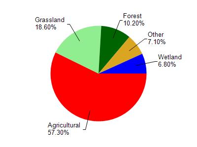
Pigeon River is located in the Pigeon River watershed which is 78.87 mi². Land use in the watershed is primarily agricultural (57.30%), grassland (18.60%) and a mix of forest (10.20%) and other uses (13.90%). This watershed has 110.34 stream miles, 769.54 lake acres and 3,149.60 wetland acres.
Nonpoint Source Characteristics
This watershed is ranked High for runoff impacts on streams, Not Ranked for runoff impacts on lakes and High for runoff impacts on groundwater and therefore has an overall rank of High. This value can be used in ranking the watershed or individual waterbodies for grant funding under state and county programs.However, all waters are affected by diffuse pollutant sources regardless of initial water quality. Applications for specific runoff projects under state or county grant programs may be pursued. For more information, go to surface water program grants.