Manitowoc
No
No
Yes
Fish and Aquatic Life
Overview
Fischer Creek, a six-mile creek, supports some seasonal migration of brook trout, rainbow trout and coho salmon from Lake Michigan with some natural reproduction occurring, meriting a Cold I or II classification. Fischer Creek is one of the Lake Michigan tributaries being managed by the WDNR as a Class II steelhead stream. As such, it receives annual smolt stockings of the ganaraska strain of steelhead. Mortality among fall-spawning brook trout was documented during a summer fish kill investigation. The fishery is limited by low flow conditions during the summer and the fall. Siltation inhibits fish spawning. Nonpoint source pollution from an unnamed tributary (T17N R23E S15) is degrading the water quality of Fischer Creek and has caused several fish kills.
In 1996, 123 acres known as the Fischer Creek property was added to the Manitowoc County park system. The state's Stewardship Fund purchased the property. (Refer to the Surface Water Quality Report for additional information on the Stewardship Fund). The Fischer Creek property stretches along a mile of Lake Michigan shoreline between Manitowoc and Sheboygan. This is the only substantial public access to the lake in the area. The tract is a mixture of young forest, marsh and grassland crossed by the creek, with seasonal runs of fish from Lake Michigan. The greatest value of the property will be for nonconsumptive recreation such as birding, walking and photography. Manitowoc County is developing a management plan for the area and will oversee its operation. Development will be limited to trails, picnic areas, parking areas near the highway and two access points. Some development work began in 1997(Crehore 1996).
From: Willman, Guy and Mike Toneys. 2001. The State of the Lakeshore Basin. Wisconsin Department of Natural Resources, Madison, WI.
Date 2001
Author Michael Toneys
Overview
Fischer Creek, a six-mile creek, supports a warm water forage fishery with some seasonal migration of brook trout, rainbow trout and coho salmon from Lake Michigan. Fischer Creek is one of the Lake Michigan tributaries being managed by the WDNR as a Class II steelhead stream. As such, it receives annual smolt stockings of the ganaraska strain of steelhead. Mortality among fall-spawning brook trout was documented during a summer fish kill investigation. The fishery is limited by low flow conditions during the summer and the fall. Siltation inhibits fish spawning. Nonpoint source pollution from an unnamed tributary (T17N R23E S15) is degrading the water quality of Fischer Creek and has caused several fish kills.
In 1996, 123 acres known as the Fischer Creek property was added to the Manitowoc County park system. The state's Stewardship Fund purchased the property. (Refer to the Surface Water Quality Report for additional information on the Stewardship Fund). The Fischer Creek property stretches along a mile of Lake Michigan shoreline between Manitowoc and Sheboygan. This is the only substantial public access to the lake in the area. The tract is a mixture of young forest, marsh and grassland crossed by the creek, with seasonal runs of fish from Lake Michigan. The greatest value of the property will be for non-consumptive recreation such as birding, walking and photography. Manitowoc County is developing a management plan for the area and will oversee its operation. Development will be limited to trails, picnic areas, parking areas near the highway and two access points. Some development work will begin in 1997 (Crehore 1996).
Unnamed Tributary to Fischer Creek T17N R23E S15
An unnamed tributary discharging to Fischer Creek is less than one mile in length. Nonpoint source pollution in this unnamed tributary has degraded the water in Fischer Creek, which serves as a spawning and nursery area for brook trout and rainbow trout. Several fish kills have been documented and the source was traced to a single pipe that is suspected to originate from an agricultural source (WDNR 1996).
Date 1997
Author Aquatic Biologist
Impaired Waters
Fischer Creek was recently evaluated during the ten-year period of 2009 through 2018 for results that were reported to the USEPA for the 2020 Clean Water Act condition report. The waterbody is considered impaired, or in poor condition for designated uses which include the quality of fish and aquatic life, recreational use, and public health and welfare (fish consumption and related). Pollutants or problems encountered during sampling (impairments) are determined based on water quality standards outlined in Wisconsin 2020 Consolidated Assessment and Listing Methodology (WisCALM). Assessment results show water conditions that are potentially harmful for Aquatic Life use due to values for total phosphorus that fall into the range expected for an aquatic community in poor health, therefore this water is listed as impaired.
Assessment results during the 2020 listing cycle indicate new impairment by total phosphorus levels too high for a healthy waterbody. Based on the most updated information, this water was proposed for the impaired waters list in 2020.
Date 2019
Author Ashley Beranek
Condition
Wisconsin has over 84,000 miles of streams, 15,000 lakes and milllions of acres of wetlands. Assessing the condition of this vast amount of water is challenging. The state's water monitoring program uses a media-based, cross-program approach to analyze water condition. An updated monitoring strategy (2015-2020) is now available. Compliance with Clean Water Act fishable, swimmable standards are located in the Executive Summary of Water Condition in 2018. See also the 'monitoring and projects' tab.
Reports
Recommendations
Partnership Project
Lakeshore Natural Resources Partnership (LNRP) is sponsoring a project to support the Friends of Hika Bay as the group continues to build appreciation for the stewardship of the frontal watersheds of Hika Bay. Project final deliverables include: all data collected, agendas and minutes for planning meetings, presentations, water quality data reports, newsletters and educational materials provided to the public. Specific project activities include: 1) Facilitating water quality sampling and analysis in collaboration with the Lakeshore Water Institute at UW-Manitowoc where students present their data at a public forum; 2) Hold a beach clean-up event at Hika Park; 3) Conduct a Project RED event in the watershed; 4) Host volunteer Restore the Shore work day events and write annual State of the Park reports for Fischer Creek and Hika Parks; 5) Host a volunteer appreciation event; 6) Hold three public educational seminars.
Restore Riparian Habitat
The Sheboygan Area Land Conservancy and Fischer Creek Alliance propose to conduct a rapid assessment and strategic plan for the preservation of priority riverine habitats in the Fischer Creek and Point Creek Watersheds. Project deliverables will include a rapid assessment and biological survey to identify and document (via digital photograph/video) habitats; partner with local units of government and citizen groups to integrate results into local land use/zoning plans; conduct public and individual meetings to share results and enhance existing Conservancy and Alliance structure; produce an educational video for public and policy maker use. A final report will describe these accomplishments to the DNR.
Management Goals
Wisconsin's Water Quality Standards provide qualitative and quantitative goals for waters that are protective of Fishable, Swimmable conditions [Learn more]. Waters that do not meet water quality standards are considered impaired and restoration actions are planned and carried out until the water is once again fishable and swimmable
Management goals can include creation or implementation of a Total Maximum Daily Load analysis, a Nine Key Element Plan, or other restoration work, education and outreach and more. If specific recommendations exist for this water, they will be displayed below online.
Monitoring
Monitoring the condition of a river, stream, or lake includes gathering physical, chemical, biological, and habitat data. Comprehensive studies often gather all these parameters in great detail, while lighter assessment events will involve sampling physical, chemical and biological data such as macroinvertebrates. Aquatic macroinvertebrates and fish communities integrate watershed or catchment condition, providing great insight into overall ecosystem health. Chemical and habitat parameters tell researchers more about human induced problems including contaminated runoff, point source dischargers, or habitat issues that foster or limit the potential of aquatic communities to thrive in a given area. Wisconsin's Water Monitoring Strategy was recenty updated.
Grants and Management Projects
Monitoring Projects
| WBIC | Official Waterbody Name | Station ID | Station Name | Earliest Fieldwork Date | Latest Fieldwork Date | View Station | View Data |
|---|
| 65800 | Fischer Creek | 10033508 | Centerville CARES Fischer Creek Station | | | Map | Data |
| 65800 | Fischer Creek | 10031811 | Fischer Creek 400ft W of LS | 9/27/2010 | 11/7/2019 | Map | Data |
| 3000447 | Unnamed | 363337 | Fischer Creek Unnamed Tributary To | 5/10/2004 | 10/26/2004 | Map | Data |
| 65800 | Fischer Creek | 10031812 | Fischer Creek at Dairyland Drive | 9/27/2010 | 10/9/2018 | Map | Data |
| 65800 | Fischer Creek | 10011679 | Fischer Creek - Fischer Cr. at S. Union Rd | | | Map | Data |
| 65800 | Fischer Creek | 363340 | Fischer Creek at Cth X | 5/10/2004 | 10/25/2004 | Map | Data |
| 65800 | Fischer Creek | 363344 | Fischer Creek at Ucker Point Creek Road | 5/10/2004 | 10/25/2004 | Map | Data |
| 65800 | Fischer Creek | 363224 | Fischer Creek at Centerville Rd (Bi) | 5/16/1979 | 1/1/2015 | Map | Data |
| 65800 | Fischer Creek | 363342 | Fischer Creek at E. Dairyland Drive | 5/10/2004 | 10/25/2004 | Map | Data |
| 65800 | Fischer Creek | 10011681 | Fischer Creek - Centerville Rd. | 4/24/1979 | 9/22/2004 | Map | Data |
| 65800 | Fischer Creek | 363338 | Fischer Creek at S. Union Road | 5/10/2004 | 10/25/2004 | Map | Data |
| 65800 | Fischer Creek | 104441 | Fischer Creek | | | Map | Data |
|
Watershed Characteristics
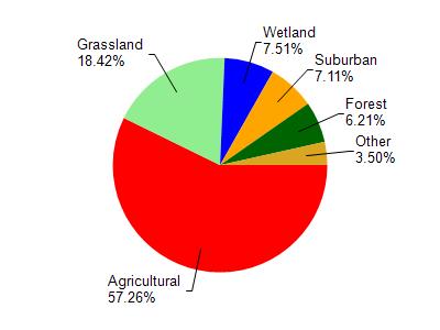
Fischer Creek is located in the Sevenmile and Silver Creeks watershed which is 112.90 mi². Land use in the watershed is primarily agricultural (57.20%), grassland (18.40%) and a mix of wetland (7.50%) and other uses (16.80%). This watershed has 184.08 stream miles, 10,577.89 lake acres and 4,732.70 wetland acres.
Nonpoint Source Characteristics
This watershed is ranked High for runoff impacts on streams, Not Ranked for runoff impacts on lakes and High for runoff impacts on groundwater and therefore has an overall rank of High. This value can be used in ranking the watershed or individual waterbodies for grant funding under state and county programs.However, all waters are affected by diffuse pollutant sources regardless of initial water quality. Applications for specific runoff projects under state or county grant programs may be pursued. For more information, go to surface water program grants.