Dane, Rock
No
No
Yes
Fish and Aquatic Life
Overview
Badfish Creek is formed by the confluence of its Oregon and Rutland Branches. Nearly 100 percent of the creek's entire length in Dane County has been ditched, straightened and widened. In contrast, in Rock County, the stream's natural morphology has been preserved. In the 1970s water quality was poor due to the large volume of effluent from MMSD and Oregon's treatment plant. MMSD has improved its treatment capabilities and quality of its effluent; consequently, the quality of water in Badfish Creek has improved.
Three MMSD reports document the improved water quality conditions of Badfish Creek. The first report, “Badfish Creek Data, 1989,” by James Fisher, discusses water chemistry changes since 1977. Biochemical oxygen demand (BOD), ammonia nitrogen, nitrite nitrogen and suspended solids have decreased while dissolved oxygen levels have increased in Badfish Creek and Oregon Branch over the period of study. Levels of total suspended solids (TSS) tend to increase at the downstream monitoring stations. It is estimated that MMSD and Oregon contribute less than 50 percent of the TSS just below Cooksville. BOD concentrations also increase downstream, indicating polluted runoff from surrounding farmland affects water quality in Badfish Creek. Based on the data and analysis, the Rock River appears to be unaffected by BOD levels in Badfish Creek.
Modifications to MMSD's Wisconsin Pollutant Discharge Elimination System (WPDES) permit suspended effluent disinfection requirements during colder months. The public raised objections to this modification. A study commissioned by MMSD and performed by the University of Wisconsin on the effects of seasonal disinfection on bacterial indicators and pathogens in the creek did not, however, find health hazards to recreational users of Badfish Creek, both with and without effluent disinfection.
Since 1977 biochemical oxygen demand (BOD), ammonia nitrogen, nitrite nitrogen and suspended solids have decreased while dissolved oxygen levels have increased in Badfish Creek and Oregon Branch over the period of study. Levels of total suspended solids (TSS) tend to increase at the downstream monitoring stations. It is estimated that MMSD and Oregon contribute less than 50 percent of the TSS just below Cooksville. BOD concentrations also increase downstream, indicating polluted runoff from surrounding farmland affects water quality in Badfish Creek.
MMSD points to four major improvements which seem to have enhanced water quality since 1983: riprapping three sections of the stream; addition of nitrification processes in the plant, which decreases ammonia discharges to the stream; changing disinfection from chlorine to ultraviolet, which eliminated chlorine and toxic by-products entering the stream; and reduction in levels of suspended solids and BOD in the treatment plant due to increased plant capacity and longer retention times for the effluent. Rock River Water Quality Management Plan, Lower Rock River Appendix. WT-668-2002. South Central Region, WDNR.
Date 2002
Author Aquatic Biologist
Historical Description
From: Ball, Joseph R., and Ronald J. Poff, Lake and Stream Classification Project. Surface Water Resources of Rock County, Department of Natural Resources, 1970.
Surface Acres = 24.14, Miles = 5.31, Gradient = 2.9 feet per mile.
Originally a small stream tributary to the Yahara River, now the recipient of effluent from the City of Madison and Oregon sewage treatment plants. The stream originates in the Dane County, enteres Rock County near Cooksville, then flows easterly to the Yahara River. Portions of the stream in Dane County have a history of being marginal trout water and a few trout were also found in Rock County. The fishery is now dominated by forage and rough species although a few northern pike, bass and catfish may migrate a short distance from the Yahara. About 457 acres of fresh meadow wetland ajoins the stream. Access is possible by navigable water at the outlet and from four bridge crossings.
Date 1970
Author Surface Water Inventory Of Wisconsin
General Condition
Badfish Creek is formed by the confluence of its Oregon and Rutland Branches. Nearly 100 percent of the creek's entire length in Dane County has been ditched, straightened and widened. In contrast, in Rock County, the stream's natural morphology has been preserved. In the 1970s water quality was quite poor due to the large volume of effluent from MMSD and Oregon's treatment plant. Since then, MMSD has improved its treatment capabilities and thus the quality of its effluent; consequently, the quality of water in Badfish Creek has improved. Since 1983, more than 42 fish species have been observed in Badfish Creek (MMSD).
The report 'Aquatic Macroinvertebrate Analysis On Badfish Creek 1981-1988,' by Jeffrey Steven, MMSD research biologist. Steven collected aquatic bug samples over an eight-year period. He used a number of different techniques including Hilsenhoff Biotic Index, species richness, and similarity indices to analyze the data. The analysis indicates water quality improves with distance downstream from MMSD's outfall until the vicinity of Old Stage Road crossing Badfish Creek. In this area other factors, likely rural polluted runoff, control the quality of the stream's water. Steven compares his biotic index and other water quality findings against water quality data found in a 1960 study and concludes water quality in Badfish Creek is now about the same level as existed prior to MMSD's discharge to the stream. (For information about MMSD, see the discussion under the Yahara River and Lake Monona Watershed [LR08].)
Date 2002
Author Aquatic Biologist
Condition
Wisconsin has over 84,000 miles of streams, 15,000 lakes and milllions of acres of wetlands. Assessing the condition of this vast amount of water is challenging. The state's water monitoring program uses a media-based, cross-program approach to analyze water condition. An updated monitoring strategy (2015-2020) is now available. Compliance with Clean Water Act fishable, swimmable standards are located in the Executive Summary of Water Condition in 2018. See also the 'monitoring and projects' tab.
Reports
Recommendations
Citizen-Based Stream Monitoring
Collect chemical, physical, and/or biological water quality data to assess the current overall stream health. The data can inform management decisions and may be used to identify impaired waters for biennial lists.
Sewer Service Area Planning
CARPC FY17
Sewer Service Area Planning
Project for Dane County Water Quality Planning updates and amendments. The Village of Oregon is a growing community with a nice quality of life. The Village’s residential growth is centered around its historic downtown. Surrounding the Village are scenic hills with agricultural fields.
County Land and Water Management Plan
Project for Dane County Water Quality Planning updates and amendments. The Village of Oregon is a growing community with a nice quality of life. The Village?s residential growth is centered around its historic downtown. Surrounding the Village are scenic hills with agricultural fields.
Standards Details
This water, from the confluence with Rutland Branch and Oregon Branch to CTH "A".
Date 2010
Author Aquatic Biologist
Management Goals
Wisconsin's Water Quality Standards provide qualitative and quantitative goals for waters that are protective of Fishable, Swimmable conditions [Learn more]. Waters that do not meet water quality standards are considered impaired and restoration actions are planned and carried out until the water is once again fishable and swimmable
Management goals can include creation or implementation of a Total Maximum Daily Load analysis, a Nine Key Element Plan, or other restoration work, education and outreach and more. If specific recommendations exist for this water, they will be displayed below online.
Monitoring
Monitoring the condition of a river, stream, or lake includes gathering physical, chemical, biological, and habitat data. Comprehensive studies often gather all these parameters in great detail, while lighter assessment events will involve sampling physical, chemical and biological data such as macroinvertebrates. Aquatic macroinvertebrates and fish communities integrate watershed or catchment condition, providing great insight into overall ecosystem health. Chemical and habitat parameters tell researchers more about human induced problems including contaminated runoff, point source dischargers, or habitat issues that foster or limit the potential of aquatic communities to thrive in a given area. Wisconsin's Water Monitoring Strategy was recenty updated.
Grants and Management Projects
Monitoring Projects
| WBIC | Official Waterbody Name | Station ID | Station Name | Earliest Fieldwork Date | Latest Fieldwork Date | View Station | View Data |
|---|
| 799500 | Badfish Creek | 543225 | Badfish Creek DS from 2nd Hwy 59 bridge | 7/26/1977 | 12/15/1980 | Map | Data |
| 799500 | Badfish Creek | 133103 | Badfish Creek at Cth A Bridge | 10/10/1985 | 6/23/2025 | Map | Data |
| 799500 | Badfish Creek | 10016544 | Badfish Creek at Old Stage Rd | 10/10/1985 | 6/25/2025 | Map | Data |
| 799500 | Badfish Creek | 10012601 | Badfish Creek - Casey Road | 10/19/2006 | 5/5/2026 | Map | Data |
| 799500 | Badfish Creek | 10034816 | Badfish Creek - Cooksville ~1000ft US Hwy 138 | 1/1/2015 | 1/1/2015 | Map | Data |
| 799500 | Badfish Creek | 10051559 | Badfish Creek at STH 138 | 10/17/2018 | 10/17/2018 | Map | Data |
| 799500 | Badfish Creek | 10052818 | Badfish Creek at Old Stone Road | 8/1/2019 | 6/25/2025 | Map | Data |
| 799500 | Badfish Creek | 543057 | Badfish Creek at Sth 59 Bridge | 10/31/2002 | 6/22/2026 | Map | Data |
| 799500 | Badfish Creek | 10016547 | Badfish Creek - 6bk4mm | | | Map | Data |
| 799500 | Badfish Creek | 543292 | Badfish Creek - Badfish Cr | | | Map | Data |
| 799500 | Badfish Creek | 10016545 | Badfish Creek - 6bk5mw | | | Map | Data |
| 799500 | Badfish Creek | 10029969 | Badfish Creek at Riley Road | 7/21/2007 | 10/17/2018 | Map | Data |
|
Watershed Characteristics
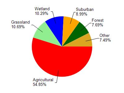
Badfish Creek is located in the Yahara River and Lake Kegonsa watershed which is 126.33 mi². Land use in the watershed is primarily agricultural (54.90%), grassland (10.70%) and a mix of wetland (10.30%) and other uses (24.20%). This watershed has 145.73 stream miles, 3,600.04 lake acres and 6,832.19 wetland acres.
Nonpoint Source Characteristics
This watershed is ranked Medium for runoff impacts on streams, Low for runoff impacts on lakes and High for runoff impacts on groundwater and therefore has an overall rank of High. This value can be used in ranking the watershed or individual waterbodies for grant funding under state and county programs.However, all waters are affected by diffuse pollutant sources regardless of initial water quality. Applications for specific runoff projects under state or county grant programs may be pursued. For more information, go to surface water program grants.