Vilas
No
No
No
Fish and Aquatic Life
Overview
Big Sand Lake, in the Deerskin River Watershed, is a 1,427.46 acre lake that falls in Vilas County. This lake is managed for fishing and swimming and is currently considered impaired.
Date 2015
Author Aquatic Biologist
Historical Description
Source: 1963, Surface Water Resources of Vilas County
Sand (Big) Lake, T-41-N, R-12-E, Section 3,
Area = 1,408 Surface Acres, Maximum Depth 35 feet
Big Sand Lake is a drainage lake of moderate fertility. It
has slightly alkaline, clear water of moderate transparency. The
bottom materials consist predominantly of sand with gravel, rock,
and muck. Only the outlet stream is considered to be navigable
water. The principal fish species present in the lake are
muskellunge, northern pike, walleye, large and smallmouth bass and
pan fish. There it's public access to the Lake by means of a town
landing, as well as by navigable water. Public use facilities
consist of three resorts with two having boat renting facilities.
There are two farms on the shore. There are 26 cottages located on
or about the shore line. The lake is used by puddle ducks and
diving ducks in fair numbers on the fall migration.
Date 1963
Author Surface Water Inventory Of Wisconsin
General Condition
Big Sand Lake (WBIC 1602600) was placed on the impaired waters list for total phosphorus in 2014 as a Two-Story Fishery Lake. Subsequently the lake has been reclassified by fisheries biologists as a Deep Lowland Lake, not Two-Story Fishery. This changed the TP criteria used. This lake was assessed during the 2018 listing cycle; new total phosphorus and chlorophyll-a sample data were clearly below the 2018 WisCALM listing thresholds for the Recreation use and the Fish and Aquatic Life use. This water was meeting these designated uses and was not considered impaired.
Date 2017
Author Ashley Beranek
Impaired Waters
Big Sand Lake (1602600) was placed on the impaired waters list for total phosphorus in 2014. The 2016 assessments showed continued impairment by phosphorus; total phosphorus sample data exceed 2016 WisCALM listing thresholds for the Recreation use and Fish and Aquatic Life use, however chlorophyll data do not exceed REC or FAL thresholds. Based on the most updated information, no change in existing impaired waters listing is needed.
Date 2015
Author Aaron Larson
Condition
Wisconsin has over 84,000 miles of streams, 15,000 lakes and milllions of acres of wetlands. Assessing the condition of this vast amount of water is challenging. The state's water monitoring program uses a media-based, cross-program approach to analyze water condition. An updated monitoring strategy (2015-2020) is now available. Compliance with Clean Water Act fishable, swimmable standards are located in the Executive Summary of Water Condition in 2018. See also the 'monitoring and projects' tab.
Reports
Management Goals
Wisconsin's Water Quality Standards provide qualitative and quantitative goals for waters that are protective of Fishable, Swimmable conditions [Learn more]. Waters that do not meet water quality standards are considered impaired and restoration actions are planned and carried out until the water is once again fishable and swimmable
Management goals can include creation or implementation of a Total Maximum Daily Load analysis, a Nine Key Element Plan, or other restoration work, education and outreach and more. If specific recommendations exist for this water, they will be displayed below online.
Monitoring
Monitoring the condition of a river, stream, or lake includes gathering physical, chemical, biological, and habitat data. Comprehensive studies often gather all these parameters in great detail, while lighter assessment events will involve sampling physical, chemical and biological data such as macroinvertebrates. Aquatic macroinvertebrates and fish communities integrate watershed or catchment condition, providing great insight into overall ecosystem health. Chemical and habitat parameters tell researchers more about human induced problems including contaminated runoff, point source dischargers, or habitat issues that foster or limit the potential of aquatic communities to thrive in a given area. Wisconsin's Water Monitoring Strategy was recenty updated.
Grants and Management Projects
Monitoring Projects
| WBIC | Official Waterbody Name | Station ID | Station Name | Earliest Fieldwork Date | Latest Fieldwork Date | View Station | View Data |
|---|
| 1602600 | Big Sand Lake | 644064 | Big Sand Lake - Deep Hole | | | Map | Data |
| 1602600 | Big Sand Lake | 10029107 | Big Sand Lake (Residual Study Point 8) | 5/28/2008 | 8/29/2008 | Map | Data |
| 1602600 | Big Sand Lake | 10029104 | Big Sand Lake (Residual Study Point 3) | 5/28/2008 | 8/29/2008 | Map | Data |
| 1602600 | Big Sand Lake | 10058860 | Big Sand Lake (1602600) - Application area A-24 | 6/10/2024 | 6/24/2024 | Map | Data |
| 1602600 | Big Sand Lake | 10029111 | Big Sand Lake (Residual Study Point 10) | 5/28/2008 | 8/29/2008 | Map | Data |
| 1602600 | Big Sand Lake | 10029110 | Big Sand Lake (Residual Study Point 9) | 5/28/2008 | 8/29/2008 | Map | Data |
| 1602600 | Big Sand Lake | 10058859 | Big Sand Lake (1602600) - Application area A-24 | 6/10/2024 | 6/24/2024 | Map | Data |
| 1602600 | Big Sand Lake | 10006015 | Big Sand Lake | 6/1/1990 | 9/30/2017 | Map | Data |
| 1602600 | Big Sand Lake | 10029106 | Big Sand Lake (Residual Study Point 5) | 5/28/2008 | 8/29/2008 | Map | Data |
| 1602600 | Big Sand Lake | 10043895 | Big Sand Lake - Eastern Part Of Lake | 7/30/2015 | 7/30/2015 | Map | Data |
| 1602600 | Big Sand Lake | 643125 | Big Sand Lake - Deep Hole | 8/6/1973 | 9/7/2025 | Map | Data |
| 1602600 | Big Sand Lake | 10029105 | Big Sand Lake (Residual Study Point 4) | 5/28/2008 | 8/29/2008 | Map | Data |
| 1602600 | Big Sand Lake | 10043896 | Big Sand Lake - Western Part Of Lake | 7/30/2015 | 7/30/2015 | Map | Data |
| 1602600 | Big Sand Lake | 10029109 | Big Sand Lake (Residual Study Point 6) | 5/28/2008 | 8/29/2008 | Map | Data |
| 1602600 | Big Sand Lake | 10018812 | Big Sand Lake -- Boat Launch | 8/7/2004 | 10/22/2025 | Map | Data |
| 1602600 | Big Sand Lake | 10058863 | Big Sand Lake (1602600) BF Thoroughfare Creek Headwater | 6/14/2024 | 6/24/2024 | Map | Data |
| 1602600 | Big Sand Lake | 10029108 | Big Sand Lake (Residual Study Point 7) | 5/28/2008 | 8/29/2008 | Map | Data |
| 1602600 | Big Sand Lake | 10029103 | Big Sand Lake (Residual Study Point 2) | 5/28/2008 | 8/29/2008 | Map | Data |
| 1602600 | Big Sand Lake | 10029102 | Big Sand Lake (Residual Study Point 1) | 5/28/2008 | 8/29/2008 | Map | Data |
| 1602600 | Big Sand Lake | 10058861 | Big Sand Lake (1602600) - Application area A-24 | 6/10/2024 | 6/24/2024 | Map | Data |
|
Watershed Characteristics
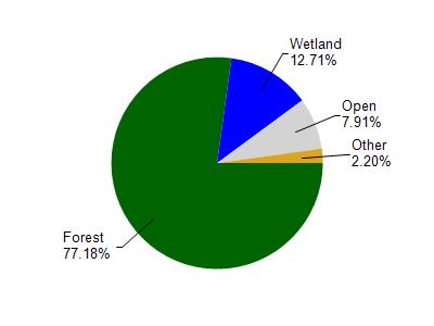
Big Sand Lake is located in the Deerskin River watershed which is 56.88 mi². Land use in the watershed is primarily forest (77.10%), wetland (12.70%) and a mix of open (7.90%) and other uses (2.20%). This watershed has 63.93 stream miles, 3,047.79 lake acres and 4,928.98 wetland acres.
Nonpoint Source Characteristics
This watershed is ranked Low for runoff impacts on streams, Medium for runoff impacts on lakes and Low for runoff impacts on groundwater and therefore has an overall rank of Low. This value can be used in ranking the watershed or individual waterbodies for grant funding under state and county programs.However, all waters are affected by diffuse pollutant sources regardless of initial water quality. Applications for specific runoff projects under state or county grant programs may be pursued. For more information, go to surface water program grants.