Rock, Walworth
No
Yes
Yes
Fish and Aquatic Life
Overview
Turtle Creek--Comus Lake to Rock-Walworth County Line This 13-mile stretch of stream (plus Comus Lake) is buffered by more than 2,000 acres of adjacent wetlands in the nearby state-owned wildlife area. This segment is, however, affected by urban polluted runoff from the city of Delavan and exhibits low dissolved oxygen and high turbidity, especially during low flow conditions. A marginal smallmouth bass fishery exists and the threatened Ozark minnow has been found in a tributary to this stretch. In the past, WDNR proposals for habitat enhancements have been deferred due to excessive polluted runoff impacts and the stream's natural limitations. This segment's potential is considered warm water forage fishery.
Date 2002
Author Aquatic Biologist
Historical Description
Turtle Creek is the second largest stream in Rock County and is an important recreational asset. The stream originates in Walworth County, enters Rock County at Fairfield and flows southwest to the Rock River just below Beloit in Illinois. Turtle Creek is managed for smallmouth bass; additional game fish species which occur in varying numbers include walleyes, black crappies, rock bass, northern pike, and channel catfish. The latter two species are concentrated in the lower reaches of the river. Carp are abundant at times, along with redhorse, suckers, and forage species.
Adjoining fresh meadow wetland totals 128 acres and is concentrated in the upper portion of the stream. About 13 percent of the wetland is wooded. Approximately 2 miles of the stream runs through the Turtle Creek Wildlife Area which includes 312 acres of public hunting and fishing grounds in Rock County. Spring flow in both Rock and Walworth Counties maintain open water the year round in the wildlife area, and approximately 2,000 mallards and 2,000 Canada geese over-winter here. The area is also used extensively by feeding and resting waterfowl during migration periods and habitat improvement has greatly increased nesting densities in recent years. The area also has a good natural pheasant population which is supplemented by stocking during hunting season. In addition to hunting and fishing, Turtle Creek is one of the better streams in southern Wisconsin for canoeing. There is also one town park and one city park located on the stream. Access is available at the wildlife area and the parks, and is possible at six town roads, two county roads and one state highway crossing.
Surface Acres = 285.1, Miles = 24.5, Gradient = 4.5 feet per mile.
From: Ball, Joseph R., and Ronald J. Poff, Lake and Stream Classification Project. Surface Water Resources of Rock County, Department of Natural Resources, 1970.
Date 1970
Author Aquatic Biologist
Impaired Waters
Turtle Creek, from its headwaters to Comus Lake, was evaluated for phosphorus in the 2022 cycle and found to have levels above the statewide criteria. This segment of Turtle Creek was added to the 2022 Impaired Waters List.
Date 2022
Author Ashley Beranek
Impaired Waters
Turtle Creek (WBIC 790300) from Rock/Walworth county line to Comus Lake in Delavan was listed for total phosphorus in 1998. This segment of Turtle Creek was assessed during the 2018 listing cycle; new biological (fish Index of Biotic Integrity (IBI) scores) sample data were clearly below the 2018 WisCALM listing thresholds for the Fish and Aquatic Life use. Based on the most updated information, no change in the existing impaired waters listing was needed.
Date 2017
Author Ashley Beranek
Impaired Waters
The 2018 assessments of Turtle Creek (IL, WI state line to Rock/Walworth county line) showed impairment by phosphorus; new total phosphorus sample data exceeded the 2018 WisCALM listing criteria for the Fish and Aquatic Life use. However, new and existing biological data did not indicate impairment (i.e. no macroinvertebrate or fish Index of Biotic Integrity (IBI) scored in the "poor" condition category). This water was also assessed for temperature; new temperature sample data exceeded the 2018 WisCALM listing criteria for the Fish and Aquatic Life use. Based on the most updated information, this water was proposed for the impaired waters list.
Date 2017
Author Ashley Beranek
Condition
Wisconsin has over 84,000 miles of streams, 15,000 lakes and milllions of acres of wetlands. Assessing the condition of this vast amount of water is challenging. The state's water monitoring program uses a media-based, cross-program approach to analyze water condition. An updated monitoring strategy (2015-2020) is now available. Compliance with Clean Water Act fishable, swimmable standards are located in the Executive Summary of Water Condition in 2018. See also the 'monitoring and projects' tab.
Reports
Recommendations
Citizen-Based Stream Monitoring
Collect chemical, physical, and/or biological water quality data to assess the current overall stream health. The data can inform management decisions and may be used to identify impaired waters for biennial lists.
Citizen-Based Stream Monitoring
Collect chemical, physical, and/or biological water quality data to assess the current overall stream health. The data can inform management decisions and may be used to identify impaired waters for biennial lists.
Nine Key Element Plan
Turtle Creek PWS Plan - Nine Key Element Plan - The purpose of this project is to develop and document water quality and land use information about the Turtle Creek Watershed so that the specific causes and critical areas contributing to nonpoint source pollution in the watershed can be identified and the most practical means for abating the pollution can be developed.
Management Goals
Wisconsin's Water Quality Standards provide qualitative and quantitative goals for waters that are protective of Fishable, Swimmable conditions [Learn more]. Waters that do not meet water quality standards are considered impaired and restoration actions are planned and carried out until the water is once again fishable and swimmable
Management goals can include creation or implementation of a Total Maximum Daily Load analysis, a Nine Key Element Plan, or other restoration work, education and outreach and more. If specific recommendations exist for this water, they will be displayed below online.
Monitoring
Monitoring the condition of a river, stream, or lake includes gathering physical, chemical, biological, and habitat data. Comprehensive studies often gather all these parameters in great detail, while lighter assessment events will involve sampling physical, chemical and biological data such as macroinvertebrates. Aquatic macroinvertebrates and fish communities integrate watershed or catchment condition, providing great insight into overall ecosystem health. Chemical and habitat parameters tell researchers more about human induced problems including contaminated runoff, point source dischargers, or habitat issues that foster or limit the potential of aquatic communities to thrive in a given area. Wisconsin's Water Monitoring Strategy was recenty updated.
Grants and Management Projects
Monitoring Projects
| WBIC | Official Waterbody Name | Station ID | Station Name | Earliest Fieldwork Date | Latest Fieldwork Date | View Station | View Data |
|---|
| 790300 | Turtle Creek | 10010874 | Turtle Creek - Turtle Creek At Heftstrom/O'Riley Rd | 5/5/1980 | 10/31/2023 | Map | Data |
| 790300 | Turtle Creek | 10010979 | Turtle Creek - Cth S /E. Cty Rd | 6/24/2016 | 11/13/2017 | Map | Data |
| 790300 | Turtle Creek | 543252 | Turtle Creek - Hwy 51 (T-1) | 5/1/1990 | 6/29/2022 | Map | Data |
| 790300 | Turtle Creek | 543244 | Turtle Creek at O'Riley Rd | 3/30/1982 | 10/1/1992 | Map | Data |
| 790300 | Turtle Creek | 543274 | Turtle Creek at Carvers Rock Rd Near Clinton WI | 5/23/2002 | 10/17/2002 | Map | Data |
| 790300 | Turtle Creek | 10029793 | Turtle Creek off Creek Rd Beloit US from Shopiere Rd | 5/6/2002 | 12/11/2017 | Map | Data |
| 790300 | Turtle Creek | 10010973 | Turtle Creek - Turtle Creek At Belding Rd/Butterfly Rd | 4/14/1998 | 10/26/2000 | Map | Data |
| 790300 | Turtle Creek | 10014334 | Turtle Creek-Colley Rd. To 100 M Downstream Of Hwy 81 Bridge | | | Map | Data |
| 790300 | Turtle Creek | 10016197 | Turtle Creek - 10 M Upstream Of Cth J (Smith Rd) | 4/14/1998 | 6/29/2022 | Map | Data |
| 790300 | Turtle Creek | 10010876 | Turtle Creek - Turtle Creek At Former Shopiere Dam/ Allyn Mem. Park | 6/3/2008 | 1/1/2015 | Map | Data |
| 790300 | Turtle Creek | 10010975 | Turtle Creek - Turtle Creek At Milwaukee Rd/ Sth 81/ Sth 43 | 10/26/2000 | 10/26/2000 | Map | Data |
| 790300 | Turtle Creek | 10054628 | Turtle Creek at Cranston Rd | | | Map | Data |
| 790300 | Turtle Creek | 10010877 | Turtle Creek - Turtle Creek ~530m Below Cth J - Shopiere | | | Map | Data |
| 790300 | Turtle Creek | 10010875 | Turtle Creek - Turtle Creek At Carvers Rock Rd. | 1/1/2015 | 1/1/2015 | Map | Data |
| 790300 | Turtle Creek | 10039491 | Turtle Creek at NW 1/4 Sec 30 T1N R13E | | | Map | Data |
| 790300 | Turtle Creek | 10010977 | Turtle Creek - Turtle Creek At Creek Road | 9/26/2022 | 10/31/2023 | Map | Data |
| 790300 | Turtle Creek | 10012287 | Turtle Creek at Heidt's backyard | 7/10/1960 | 10/5/2025 | Map | Data |
| 790300 | Turtle Creek | 10041022 | Turtle Creek 390m US of Town of Turtle Canoe Launch off of Creek Road | 1/1/2015 | 1/1/2015 | Map | Data |
| 790300 | Turtle Creek | 10010974 | Turtle Creek - Turtle Creek At Sth 51 In Beloit | | | Map | Data |
| 790300 | Turtle Creek | 10035414 | Turtle Creek - Area of Open Water | 7/17/2010 | 7/4/2011 | Map | Data |
| 790300 | Turtle Creek | 10010873 | Turtle Creek - Turtle Creek At Lathers Rd. | 4/14/1998 | 9/2/2015 | Map | Data |
| 790300 | Turtle Creek | 10030922 | Turtle Creek -- Sweet Allyn Park Canoe Launch | 6/21/2010 | 6/22/2026 | Map | Data |
| 790300 | Turtle Creek | 10041023 | Turtle Creek 160m DS of I90 East Bound bridge crossing | 1/1/2015 | 1/1/2015 | Map | Data |
| 790300 | Turtle Creek | 543254 | Turtle Creek - Below Hwy S (T-3) | 5/1/1990 | 10/26/2000 | Map | Data |
| 790300 | Turtle Creek | 543283 | Turtle Creek at Colley Road In Beloit | 7/15/2005 | 6/24/2017 | Map | Data |
| 790300 | Turtle Creek | 543243 | Turtle Creek at Sth 140 (Bi Sur) | 5/5/1980 | 7/15/2023 | Map | Data |
| 790300 | Turtle Creek | 543249 | Turtle Creek at Carvers Rock Rd Near Clinton WI | 9/7/1999 | 6/29/2023 | Map | Data |
| 790300 | Turtle Creek | 10061161 | Town of Turtle Canoe Launch | | | Map | Data |
|
Watershed Characteristics
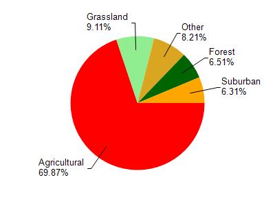
Turtle Creek is located in the Turtle Creek watershed which is 288.47 mi². Land use in the watershed is primarily agricultural (69.80%), grassland (9.10%) and a mix of forest (6.50%) and other uses (14.50%). This watershed has 339.80 stream miles, 590.58 lake acres and 6,590.97 wetland acres.
Nonpoint Source Characteristics
This watershed is ranked Not Available for runoff impacts on streams, Not Available for runoff impacts on lakes and High for runoff impacts on groundwater and therefore has an overall rank of High. This value can be used in ranking the watershed or individual waterbodies for grant funding under state and county programs.However, all waters are affected by diffuse pollutant sources regardless of initial water quality. Applications for specific runoff projects under state or county grant programs may be pursued. For more information, go to surface water program grants.