Price
No
No
Yes
Fish and Aquatic Life
Overview
Pixley Flowage is a soft water, drainage impoundment on the Flambeau River. It has a 21-ft head control structure on the outlet. The average outlet flow is estimated to be 831.5 ft(3)/sec. The dam is owned and operated by the Flambeau Paper Company to produce electric power for their mill at Park Falls. This flowage, like the one above it, has been subject to aggravation from paper mill discharge in the past. The installation of a waste sulphite evaporator at the mill has helped correct this situation. Pixley Flowage has a fish population of northern pike, walleyes, perch, largemouth bass, black crappies, rock bass, pumpkinseeds, black bullheads, white suckers, redhorse, rock sturgeons and minnows. It contains three wooded islands. The flowage littoral bottom is 15% sand, 5% gravel, 70% rubble and 10% muck. The shoreline is 95% upland hardwood and pine with several small sedge marshes and tamarack swamps making up the remainder. Aquatic vegetation is abundant and found throughout the flowage. Mallards, teal, hooded mergansers and wood ducks nest along the flowage each year. Other ducks and geese use the flowage during their spring and fall migrations. Furbearer use is significant with muskrats and beaver present. Private development consists of eight cottages. Public access is available on the northeast side of the lake on land owned by the Town of Lake.
Source: 1983, Surface Water Resources of Price County,WI: WI-DNR Pixley Flowage - T39N-T40N, RIW, Sec. 4, 5, 8 9, 27, 28, 33, 34. Surface area = 334.0 acres, maximum depth = 24 ft, MPA = 26 ppm, Secchi disk = 4 ft.
Date 1983
Author Aquatic Biologist
Recommendations
Land Acquisition
Price County will acquire 93.5 acres of land with 6,800 feet of undeveloped frontage on Smith Lake, a flowage of the Flambeau River.
Monitor Fish Tissue
Management Goals
Wisconsin's Water Quality Standards provide qualitative and quantitative goals for waters that are protective of Fishable, Swimmable conditions [Learn more]. Waters that do not meet water quality standards are considered impaired and restoration actions are planned and carried out until the water is once again fishable and swimmable
Management goals can include creation or implementation of a Total Maximum Daily Load analysis, a Nine Key Element Plan, or other restoration work, education and outreach and more. If specific recommendations exist for this water, they will be displayed below online.
Monitoring
Monitoring the condition of a river, stream, or lake includes gathering physical, chemical, biological, and habitat data. Comprehensive studies often gather all these parameters in great detail, while lighter assessment events will involve sampling physical, chemical and biological data such as macroinvertebrates. Aquatic macroinvertebrates and fish communities integrate watershed or catchment condition, providing great insight into overall ecosystem health. Chemical and habitat parameters tell researchers more about human induced problems including contaminated runoff, point source dischargers, or habitat issues that foster or limit the potential of aquatic communities to thrive in a given area. Wisconsin's Water Monitoring Strategy was recenty updated.
Grants and Management Projects
Monitoring Projects
| WBIC | Official Waterbody Name | Station ID | Station Name | Earliest Fieldwork Date | Latest Fieldwork Date | View Station | View Data |
|---|
| 2288900 | Pixley Flowage | 10031178 | Pixley Flowage middle area | 5/28/1992 | 4/20/2010 | Map | Data |
| 2225000 | Flambeau River | 513012 | Flambeau River - Nr Sec Line Up Pixley | 6/28/1975 | 8/3/1988 | Map | Data |
| 2288900 | Pixley Flowage | 513160 | Pixley Flowage - Pixley Flowage | | | Map | Data |
| 2288900 | Pixley Flowage | 513011 | Flambeau River - Just Abv Smith Lake | 6/28/1975 | 8/3/1988 | Map | Data |
| 2225000 | Flambeau River | 513013 | Flambeau River - Pixley Dam Hdrace Spooner | 2/21/1975 | 3/24/1998 | Map | Data |
| 2225000 | Flambeau River | 513014 | Flambeau River at Pixley Dam Tailrac | 6/28/1975 | 6/29/2006 | Map | Data |
| 2288900 | Pixley Flowage | 10031179 | Pixley Flowage lower end | 4/20/2010 | 4/20/2010 | Map | Data |
| 2288900 | Pixley Flowage | 10014587 | Pixley Flowage | 9/16/2004 | 9/21/2017 | Map | Data |
| 2288900 | Pixley Flowage | 10029672 | Pixley Flowage - Headwater Above Dam | 4/4/2012 | 8/12/2020 | Map | Data |
| 2288900 | Pixley Flowage | 513214 | Pixley Flowage - T39r1w S4 | | | Map | Data |
|
Watershed Characteristics
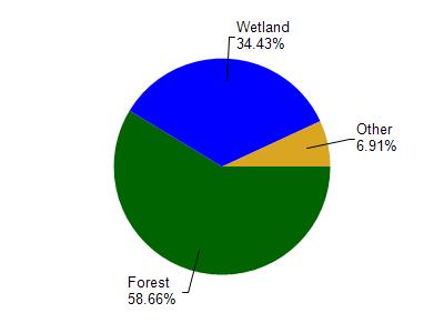
Pixley Flowage is located in the Upper North Fork Flambeau River watershed which is 158.21 mi². Land use in the watershed is primarily forest (58.60%), wetland (34.40%) and a mix of grassland (2.90%) and other uses (4.00%). This watershed has 163.80 stream miles, 629.65 lake acres and 33,475.50 wetland acres.
Nonpoint Source Characteristics
This watershed is ranked Low for runoff impacts on streams, Low for runoff impacts on lakes and Low for runoff impacts on groundwater and therefore has an overall rank of Low. This value can be used in ranking the watershed or individual waterbodies for grant funding under state and county programs.However, all waters are affected by diffuse pollutant sources regardless of initial water quality. Applications for specific runoff projects under state or county grant programs may be pursued. For more information, go to surface water program grants.