Polk
No
No
Yes
Fish and Aquatic Life
Overview
Coon Lake T37N, R17W, Sec. 27 Surface Acres=38.7, S.D.F.=1.43, Maximum Depth=15 ft., M.P.A. = 27 A landlocked lake with fish populations consisting of largemouth bass, bluegills and bullheads. Subject to periodic winterkill and algal bloom problems. Located in the City of Frederic, it is surrounded by public park land. No private development on its immediate frontage. Access by road is unimproved. Ten acres of nonwooded wetlands adjoin it. Mallards and bluewing teal nest here. Hunting is restricted by local ordinance. Swimming use is limited by its existing conditions.
Date
Author Aquatic Biologist
Impaired Waters
Coon Lake (WBIC 2642000) was assessed during the 2018 listing cycle; total phosphorus sample data clearly exceeded the 2018 WisCALM listing thresholds for the Recreation use and Fish and Aquatic Life use. This lake was proposed for total phosphorus listing in 2018.
Date 2017
Author Ashley Beranek
Condition
Wisconsin has over 84,000 miles of streams, 15,000 lakes and milllions of acres of wetlands. Assessing the condition of this vast amount of water is challenging. The state's water monitoring program uses a media-based, cross-program approach to analyze water condition. An updated monitoring strategy (2015-2020) is now available. Compliance with Clean Water Act fishable, swimmable standards are located in the Executive Summary of Water Condition in 2018. See also the 'monitoring and projects' tab.
Reports
Recommendations
Habitat Restoration - Shoreland
Practices include: a 350 ft2 native planting and a rain garden on one property.
Best Management Practices, Implement
The Village of Frederic will implement best practices described in Wisconsin's 2014-2017 Healthy Lakes Implementation Plan at Coon Lake Park. Practices include: a 350 ft2 native planting and a rain garden. The site will serve as a demonstration site with Healthy Lakes signage. The Village should coordinate with the DNR on the demonstration sign content. The best practices require a contract to remain in effect for 10 years and must include minimum operation and maintenance requirements and data collection as described in grant condition #17.
Water Quality Modeling
34948609
Monitor Water Quality or Sediment
34948609
Stormwater Planning, Implementation
Aquatic Plant Monitoring or Survey
Educate and engage residents
34948609
Watershed Mapping or Assessment
34948609
Management Goals
Wisconsin's Water Quality Standards provide qualitative and quantitative goals for waters that are protective of Fishable, Swimmable conditions [Learn more]. Waters that do not meet water quality standards are considered impaired and restoration actions are planned and carried out until the water is once again fishable and swimmable
Management goals can include creation or implementation of a Total Maximum Daily Load analysis, a Nine Key Element Plan, or other restoration work, education and outreach and more. If specific recommendations exist for this water, they will be displayed below online.
Monitoring
Monitoring the condition of a river, stream, or lake includes gathering physical, chemical, biological, and habitat data. Comprehensive studies often gather all these parameters in great detail, while lighter assessment events will involve sampling physical, chemical and biological data such as macroinvertebrates. Aquatic macroinvertebrates and fish communities integrate watershed or catchment condition, providing great insight into overall ecosystem health. Chemical and habitat parameters tell researchers more about human induced problems including contaminated runoff, point source dischargers, or habitat issues that foster or limit the potential of aquatic communities to thrive in a given area. Wisconsin's Water Monitoring Strategy was recenty updated.
Grants and Management Projects
Monitoring Projects
| WBIC | Official Waterbody Name | Station ID | Station Name | Earliest Fieldwork Date | Latest Fieldwork Date | View Station | View Data |
|---|
| 2642000 | Coon Lake | 10005036 | Coon Lake | 9/5/2000 | 8/1/2025 | Map | Data |
| 2642000 | Coon Lake | 493212 | Coon Lake - Deep Hole | 11/17/2004 | 1/1/2015 | Map | Data |
| 2642000 | Coon Lake | 10017598 | Coon Lake -- Access | 10/23/2007 | 8/5/2024 | Map | Data |
|
Watershed Characteristics
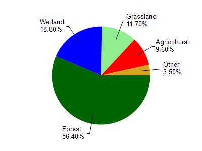
Coon Lake is located in the Trade River watershed which is 194.93 mi². Land use in the watershed is primarily forest (56.40%), wetland (18.80%) and a mix of grassland (11.70%) and other uses (13.10%). This watershed has 166.68 stream miles, 2,902.48 lake acres and 21,757.05 wetland acres.
Nonpoint Source Characteristics
This watershed is ranked Medium for runoff impacts on streams, Not Ranked for runoff impacts on lakes and Low for runoff impacts on groundwater and therefore has an overall rank of Low. This value can be used in ranking the watershed or individual waterbodies for grant funding under state and county programs.However, all waters are affected by diffuse pollutant sources regardless of initial water quality. Applications for specific runoff projects under state or county grant programs may be pursued. For more information, go to surface water program grants.