Wood
No
No
No
Fish and Aquatic Life
Overview
Lake Dexter, T22N, R3E, S14
Surface Acres = 300, S.D.F. = 3.28, Maximum Depth = 14 ft
Lake Dexter is a soft water, recreational drainage impoundment located on the Yellow River. The dam has a 15-foot head and it is owned by Wood County. The light brown water is alkaline and it has a low transparency. Flowage construction was completed in 1965 and it is a part of Wood County's Dexter Park. Northern pike, walleyes, largemouth bass, bluegills, black bullheads, white suckers, black crappies, and redhorse comprise the present fishery. Although a considerable portion of the Yellow River and its tributaries above the dam were chemically treated in an effort to eliminate undesirable fish species before the dam gates were closed, it is likely that carp will be present sometime in the future. Public access is available from the county park. There are five dwellings. Several species of ducks nest at the flowage and it is also used by migrating diving and puddle ducks. At present, muskrats appear insignificant, but use by this furbearer may be expected to increase.
Source: 1967, Surface Water Resources of Wood County
Date 1967
Author Aquatic Biologist
Impaired Waters
Dexter Lake was recently evaluated during the ten-year period of 2009 through 2018 for results that were reported to the USEPA for the 2020 Clean Water Act condition report. The waterbody is considered impaired, or in poor condition for designated uses which include the quality of fish and aquatic life, recreational use, and public health and welfare (fish consumption and related). Pollutants or problems encountered during sampling (impairments) are determined based on water quality standards outlined in Wisconsin 2020 Consolidated Assessment and Listing Methodology (WisCALM). Assessment results show water conditions that are potentially harmful for Aquatic Life and Recreation uses due to values for total phosphorus that fall into the range expected for an aquatic community in poor health, therefore this water is listed as impaired.
Assessment results during the 2020 listing cycle show total phosphorus and chlorophyll levels that indicate impairment to Aquatic Life and Recreation uses, according to 2020 WisCALM standards. Based on the most updated information, in 2020 the impairment of excess algal growth was added to the total phosphorus listing. This water has been listed since 1998 for E. coli and since 2010 for total phosphorus.
Date 2019
Author Ashley Beranek
Impaired Waters
Dexter Lake (1369900) was placed on the impaired waters list for E. coli in 1998 and for total phosphorus in 2010. The 2016 assessments showed continued impairment by phosphorus; total phosphorus sample data overwhelmingly exceeded 2016 WisCALM listing thresholds for the Recreation use and Fish and Aquatic Life use, and chlorophyll data exceeded only REC thresholds. Based on the most updated information, no change in existing impaired waters listing is needed.
Date 2015
Author Aaron Larson
Condition
Wisconsin has over 84,000 miles of streams, 15,000 lakes and milllions of acres of wetlands. Assessing the condition of this vast amount of water is challenging. The state's water monitoring program uses a media-based, cross-program approach to analyze water condition. An updated monitoring strategy (2015-2020) is now available. Compliance with Clean Water Act fishable, swimmable standards are located in the Executive Summary of Water Condition in 2018. See also the 'monitoring and projects' tab.
Reports
Recommendations
TMDL Monitoring
The Purpose of this project is to conduct sampling that is required to complete a TMDL on the Dexter Lake watershed. The previous two years were used to collect enough data to list Dexter Lake on the 303D list with nutrients as an impairment.
Monitor or Propose 303(d) Listing
Dexter Lake FY07 303D VALIDATION, FY07 SPECIAL STUDY WCR 303d and TMDL
Management Goals
Wisconsin's Water Quality Standards provide qualitative and quantitative goals for waters that are protective of Fishable, Swimmable conditions [Learn more]. Waters that do not meet water quality standards are considered impaired and restoration actions are planned and carried out until the water is once again fishable and swimmable
Management goals can include creation or implementation of a Total Maximum Daily Load analysis, a Nine Key Element Plan, or other restoration work, education and outreach and more. If specific recommendations exist for this water, they will be displayed below online.
Monitoring
Monitoring the condition of a river, stream, or lake includes gathering physical, chemical, biological, and habitat data. Comprehensive studies often gather all these parameters in great detail, while lighter assessment events will involve sampling physical, chemical and biological data such as macroinvertebrates. Aquatic macroinvertebrates and fish communities integrate watershed or catchment condition, providing great insight into overall ecosystem health. Chemical and habitat parameters tell researchers more about human induced problems including contaminated runoff, point source dischargers, or habitat issues that foster or limit the potential of aquatic communities to thrive in a given area. Wisconsin's Water Monitoring Strategy was recenty updated.
Grants and Management Projects
Monitoring Projects
| WBIC | Official Waterbody Name | Station ID | Station Name | Earliest Fieldwork Date | Latest Fieldwork Date | View Station | View Data |
|---|
| 1369900 | Dexter Lake | 10018199 | Lake Dexter -- Access - West Side Of Lake | 5/16/2006 | 6/15/2012 | Map | Data |
| 1369900 | Dexter Lake | 10007525 | Lake Dexter | 7/27/1999 | 7/8/2020 | Map | Data |
| 1369900 | Dexter Lake | 10040170 | Lake Dexter Beach (WBIC 1369900) | | | Map | Data |
|
Watershed Characteristics
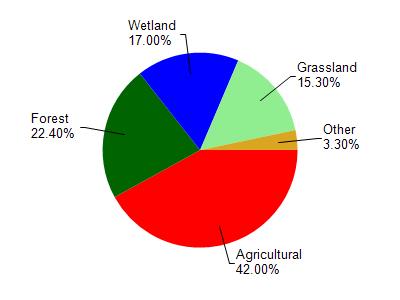
Dexter Lake is located in the Upper Yellow (Wood Co.) River watershed which is 212.95 mi². Land use in the watershed is primarily agricultural (42%), forest (22.40%) and a mix of wetland (17%) and other uses (18.60%). This watershed has stream miles, lake acres and 22,147.27 wetland acres.
Nonpoint Source Characteristics
This watershed is ranked High for runoff impacts on streams, High for runoff impacts on lakes and High for runoff impacts on groundwater and therefore has an overall rank of High. This value can be used in ranking the watershed or individual waterbodies for grant funding under state and county programs.However, all waters are affected by diffuse pollutant sources regardless of initial water quality. Applications for specific runoff projects under state or county grant programs may be pursued. For more information, go to surface water program grants.