Shawano
No
No
No
Fish and Aquatic Life
Overview
Loon Lake, located in Wescott Township of Shawano County, has a surface area of 305 acres and a maximum depth of 22 feet (see attached map). This fertile, dark-water lake is fed by groundwater seepage and by two inlets: Lulu Creek and Loon Creek. Loon Lake’s 8,465-acre watershed is predominantly upland forest and swamp. Loon Lake is drained by one outlet, Loon Creek, which flows into Washington Lake, then Shawano Lake, which ultimately drains to the Wolf River. The east side of Loon Lake is upland and is developed with cottages. The west side of the lake is predominantly wetland and remains in a natural state. A public boat landing equipped with a wheelchair-accessible pier is located on the south end of the lake.
Date 2010
Author Loon Lake Property Owners Association
Overview
Update to Comprehensive Management Plan
The Loon Lake - Wescott Management District continues to operate under the 2003 Comprehensive Management Plan for (on file with DNR). Based on DNR (see attached letter from Kathy Dax) and USACoE input, the Comprehensive Management Plan has been tentativelyscheduled to be updated after the USACoE completes its resear ch. The update of this plan is
expected to take place within the timeframe of this grant (2009-2011). In addition, the DNR Bureau of Research conducted a thorough point-intercept aquatic plant survey in 2006, 2007 and 2008.
Components of the updated plan will include analysis of annual survey data, comparisons with previous plant survey data, and review of results from the research conducted by the USACoE. Other elements will include a review of recent lake management practices, as well as collection and review of water quality data. The plan will also include a discussion of plant management
options and recommendations for future management of Loon Lake.
Project Products, Deliverables & Data Sharing In addition to the eventual updated management plan, deliverables will include annual progress
reports to the DNR, Shawano County, and USACoE following each field season. The reports will present a summary of educational and control activities, survey results, and recommendations for the following season. Data generated during this project will be used to evaluate the effectiveness of management efforts and to determine the best course of action for
future management of Loon Lake. We view this as a demonstration project; the management district will be pleased to participate in data sharing arrangements that DNR may establish in coming years in order to assist other communities with their efforts to control AIS.
Date 2010
Author Loon Lake Property Owners Association
Historical Description
Source: 1968, Surface Water Resources of Shawano County
Loon Lake, T27N, R16E, Section 11
Surface Acres = 276.6, S.D.F. = 1.50, Maximum Depth = 23 feet
A medium hard water drainage lake having slightly alkaline,
light brown water of low transparency. Littoral materials consist
of sand (55 percent), muck (35 percent) and some gravel. The
shoreline is predominantly upland (60 percent); however, a
significant portion is wetland consisting of marsh, conifers, shrub
and some bog. Fish species found in this lake are northern pike,
largemouth bass, perch, bluegill, black crappie, rock bass,
pumpkinseed, black bullhead, white sucker, longnose gar, and
bowfin. On occasion walleye and brook trout have been reported
present. Brook trout undoubtedly make entry from the inlet stream,
Loon Creek, which is managed for trout. The lake is of value to
nesting waterfowl. Puddle ducks and diving ducks utilize these
waters on their spring and fall migrations. Public access without
nearby parking from the end of a town road is available as well as
that of navigable water via the outlet stream (Loon Creek) which is
tributary to Washington and Shawano Lakes. Commercial facilities
consist of four resorts and one boat rental. There are 96
dwellings and one organizational camp (girl's) located on the
shoreline.
Date 1968
Author Surface Water Inventory Of Wisconsin
Recommendations
Land Acquisition
The Loon Lake Wescott Management District proposes to purchase 32.1 acres of vacantland with approximately 1/4 mile of frontage on Loon Lake. The Management District will keep it in its naturally landscaped state for conservancy purposes.
Land Acquisition
The Loon Lake Wescott Management District will acquire 89.25 acres of primarily lowland with approximately 1/2 mile of frontage on Loon Lake. The district will maintain the land in a wild and natural condition to protect the water quality of Loon Lake.
Management Goals
Wisconsin's Water Quality Standards provide qualitative and quantitative goals for waters that are protective of Fishable, Swimmable conditions [Learn more]. Waters that do not meet water quality standards are considered impaired and restoration actions are planned and carried out until the water is once again fishable and swimmable
Management goals can include creation or implementation of a Total Maximum Daily Load analysis, a Nine Key Element Plan, or other restoration work, education and outreach and more. If specific recommendations exist for this water, they will be displayed below online.
Monitoring
Monitoring the condition of a river, stream, or lake includes gathering physical, chemical, biological, and habitat data. Comprehensive studies often gather all these parameters in great detail, while lighter assessment events will involve sampling physical, chemical and biological data such as macroinvertebrates. Aquatic macroinvertebrates and fish communities integrate watershed or catchment condition, providing great insight into overall ecosystem health. Chemical and habitat parameters tell researchers more about human induced problems including contaminated runoff, point source dischargers, or habitat issues that foster or limit the potential of aquatic communities to thrive in a given area. Wisconsin's Water Monitoring Strategy was recenty updated.
Grants and Management Projects
Monitoring Projects
| WBIC | Official Waterbody Name | Station ID | Station Name | Earliest Fieldwork Date | Latest Fieldwork Date | View Station | View Data |
|---|
| 323800 | Loon Lake | 10054186 | Loon lake herbicide concentration monitoirng | | | Map | Data |
| 323800 | Loon Lake | 10005731 | Loon Lake | 3/31/1990 | 8/20/2024 | Map | Data |
| 323800 | Loon Lake | 10019172 | Loon Lake -- Access at Near Loon Lake Cir And Ponderosa Rd | 9/30/2004 | 12/19/2025 | Map | Data |
| 323800 | Loon Lake | 593002 | Loon Lake - Deep Hole | 2/23/1976 | 5/20/2026 | Map | Data |
| 323800 | Loon Lake | 593069 | Loon Lake - Deep Hole Near Shawano WI | 7/10/2004 | 9/8/2004 | Map | Data |
| 323800 | Loon Lake | 10056223 | Loon Lake - L1 (Application Area) | 6/2/2022 | 6/9/2022 | Map | Data |
| 323800 | Loon Lake | 10056224 | Loon Lake - L2 (South AOPI) | 6/3/2022 | 6/9/2022 | Map | Data |
|
Watershed Characteristics
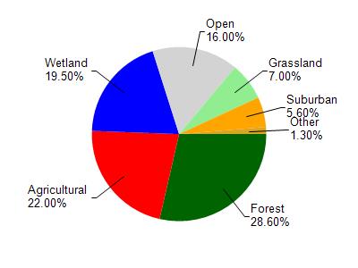
Loon Lake is located in the Shawano Lake watershed which is 71.16 mi². Land use in the watershed is primarily forest (28.60%), agricultural (22%) and a mix of wetland (19.50%) and other uses (29.90%). This watershed has 76.28 stream miles, 7,438.74 lake acres and 7,573.91 wetland acres.
Nonpoint Source Characteristics
This watershed is ranked Not Ranked for runoff impacts on streams, High for runoff impacts on lakes and High for runoff impacts on groundwater and therefore has an overall rank of High. This value can be used in ranking the watershed or individual waterbodies for grant funding under state and county programs.However, all waters are affected by diffuse pollutant sources regardless of initial water quality. Applications for specific runoff projects under state or county grant programs may be pursued. For more information, go to surface water program grants.