Monroe
Yes
Yes
Yes
Fish and Aquatic Life
Overview
Dustin Creek, a tributary to Rathbone Creek, is listed as a Class I trout stream in Wisconsin Trout Streams (WDNR). However, the local fishery manager considers it a Class II trout stream. The stream is limited by lack of in-stream habitat caused by a shifting sand bottom (Wright).
From: Koperksi, Cindy. 1999. Black River Water Quality Management Plan (draft). Wisconsin Department of Natural Resources, Madison, WI.
Date 1999
Author Cynthia Koperski
Impaired Waters
The 2018 assessments of Dustin Creek showed impairment by phosphorus; new total phosphorus sample data overwhelmingly exceeded the 2018 WisCALM listing criteria for the Fish and Aquatic Life use. However, available biological data did not indicate impairment. New macroinvertebrate sample data were assessed, but no macroinvertebrate Index of Biotic Integrity (IBI) scored in the "poor" condition category. Based on the most updated information, this water was proposed for the impaired waters list.
Date 2017
Author Ashley Beranek
Condition
Wisconsin has over 84,000 miles of streams, 15,000 lakes and milllions of acres of wetlands. Assessing the condition of this vast amount of water is challenging. The state's water monitoring program uses a media-based, cross-program approach to analyze water condition. An updated monitoring strategy (2015-2020) is now available. Compliance with Clean Water Act fishable, swimmable standards are located in the Executive Summary of Water Condition in 2018. See also the 'monitoring and projects' tab.
Reports
Recommendations
Control Streambank Erosion
The goals of the project are to reduce the streambank erosion by placing riprap at necessary locations. The erosion of the stream bed itself will also be reduced by placing gravel beds immediately upstream of the Rock Wiers at strategic locations. The DNR's LaCrosse office did a stream survey in the summer of 2001 and will conduct another at a later date to compare the results. Project results will be shared with the public through media coverage -- local newspaper and possibly an outdoors television episode. A final report will be submitted to the River Protection Program. The DNR will be provided with both a paper and electronic copy of the final report. Information will be disseminated to the public as described in the grant application.
Monitor or Propose 303(d) Listing
Management Goals
Wisconsin's Water Quality Standards provide qualitative and quantitative goals for waters that are protective of Fishable, Swimmable conditions [Learn more]. Waters that do not meet water quality standards are considered impaired and restoration actions are planned and carried out until the water is once again fishable and swimmable
Management goals can include creation or implementation of a Total Maximum Daily Load analysis, a Nine Key Element Plan, or other restoration work, education and outreach and more. If specific recommendations exist for this water, they will be displayed below online.
Monitoring
Monitoring the condition of a river, stream, or lake includes gathering physical, chemical, biological, and habitat data. Comprehensive studies often gather all these parameters in great detail, while lighter assessment events will involve sampling physical, chemical and biological data such as macroinvertebrates. Aquatic macroinvertebrates and fish communities integrate watershed or catchment condition, providing great insight into overall ecosystem health. Chemical and habitat parameters tell researchers more about human induced problems including contaminated runoff, point source dischargers, or habitat issues that foster or limit the potential of aquatic communities to thrive in a given area. Wisconsin's Water Monitoring Strategy was recenty updated.
Grants and Management Projects
Monitoring Projects
| WBIC | Official Waterbody Name | Station ID | Station Name | Earliest Fieldwork Date | Latest Fieldwork Date | View Station | View Data |
|---|
| 1694300 | Dustin Creek | 10014016 | Dustin Creek Station 7-1961-Se 1/4 Se 1/4 S23-Starts At Cth S Bridge Crossing. | | | Map | Data |
| 1694300 | Dustin Creek | 10014017 | Dustin Creek Station 3-1976-Nw 1/4 Sw 1/4 S18-Starts At Benton Road Bridge Crossing. | 11/1/2006 | 11/1/2006 | Map | Data |
| 1694300 | Dustin Creek | 10013049 | Dustin Creek St. 2 - 2005 Cty Hwy S | 9/14/2010 | 10/1/2015 | Map | Data |
| 1694300 | Dustin Creek | 10022458 | Dustin Creek - Follendorf Property T19n R4w S24 | | | Map | Data |
| 1694300 | Dustin Creek | 10013048 | Dustin Creek St. 1 - 2005 Schoeber Fisherman Access | | | Map | Data |
| 1694300 | Dustin Creek | 10047581 | Dustin Creek at CTH S East of Bell Rd | | | Map | Data |
|
Watershed Characteristics
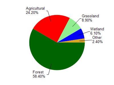
Dustin Creek is located in the Big and Douglas Creeks watershed which is 210.33 mi². Land use in the watershed is primarily forest (58.40%), agricultural (24.20%) and a mix of grassland (8.90%) and other uses (8.50%). This watershed has 375.17 stream miles, 473.57 lake acres and 7,564.97 wetland acres.
Nonpoint Source Characteristics
This watershed is ranked High for runoff impacts on streams, Not Available for runoff impacts on lakes and Medium for runoff impacts on groundwater and therefore has an overall rank of Medium. This value can be used in ranking the watershed or individual waterbodies for grant funding under state and county programs.However, all waters are affected by diffuse pollutant sources regardless of initial water quality. Applications for specific runoff projects under state or county grant programs may be pursued. For more information, go to surface water program grants.