Douglas
No
No
Yes
Fish and Aquatic Life
Overview
Red clay erosion contributes to large amounts of sediment and turbidity in the river. The river is an important spawning area for walleye, northern pike, longnose and white suckers, burbot and other members of a diverse fishery; water quality is very important for successful reproduction for these species (Pratt 1996).
The outfall of the village of Superior wastewater treatment plant at SW S10 T48 N R14W then along a diffuse surface drainage to the Pokegama River, has been recommended for inclusion in the revision of NR104 as a limited aquatic life water. From the confluence of this drainage to the mouth of the river at the St. Louis River in Pokegama Bay, the Pokegama is recommended for inclusion in NR104 as a limited forage fishery.
An unnamed tributary T48N R14W S04 NESW, receives the discharge from the Duluth, Winnipeg and Pacific Railway Switching Yards industrial and sanitary wastewater treatment system. The plant outfall discharges to the upper end of a spill containment impoundment that also receives runoff from the railyard and wetland drainage. From the mouth of the tributary to the outfall at T48N R14W S17 is recommended for inclusion in NR104 as a limited forage fishery. After discharging from the impoundment, the drainageway receives additional channelized wetland and yard drainage. These sources form the headwaters of an intermittent Pokegama River tributary. The tributary channel is poorly defined in its upper reaches where it is surrounded by extensive wetland and lowland scrub. Farther down the drainage, the stream takes on the typical patterns of steeply cut clay banks and scoured, sometimes deeply cut channel indicative of the flashy streams in this region. During low flow periods, the stream may have no discharge. While during sampling no discharge occurred from the containment impoundment, a heavy planktonic algae bloom was present throughout the impoundment and abundant mats of filamentous algae were in place near the bottom end of the impoundment. Discharge samples from the weir showed moderate increases in biochemical oxygen demand and nutrients. Indicative of the heavy algae bloom occurring in the impoundment were an elevated pH and a super-saturated dissolved oxygen level. (Prenn May 21, 1991)
Date 1999
Author Aquatic Biologist
Historical Description
The Pokegama River was recommended for inclusion in the revision of NR104 (1977) as a limited aquatic life water (LFF) from the confluence of the drainage for the outfall of the Village of Superior's wastewater treatment plant to the mouth of the river at the St. Louis River in Pokegama Bay. However, Pratt (1996) notes that the river is an important spawning area for walleye, northern pike, longnose and white suckers, burbot and other members of a diverse fishery and water quality is very important for successful reproduction for these species. Based on a diverse fishery with gamefish present, this LFF designation does not appear appropriate; rather, it would appear the Pokegama should be designated as a warmwater sport fishery (WWSF) from it's mouth up to at least Hwy 105 (~ river mile 4.0) and possibly further, at which point it would most likely change to a warm-water forage fishery (WWFF).
Condition monitoring and evaluation of the Pokegama River for current, attainable, and most appropriate designated use category throughout its system is recommended.
Date 2010
Author Cordell Manz
Impaired Waters
The 2018 assessments of the Pokegama River showed impairment by phosphorus; new total phosphorus sample data exceeded 2018 WisCALM listing criteria for the Fish and Aquatic Life use. However, available biological data did not indicate impairment (i.e. no macroinvertebrate or fish Index of Biotic Integrity (IBI) scored in the "poor" condition category). Based on the most updated information, this water was proposed for the impaired waters list.
Date 2017
Author Ashley Beranek
Condition
Wisconsin has over 84,000 miles of streams, 15,000 lakes and milllions of acres of wetlands. Assessing the condition of this vast amount of water is challenging. The state's water monitoring program uses a media-based, cross-program approach to analyze water condition. An updated monitoring strategy (2015-2020) is now available. Compliance with Clean Water Act fishable, swimmable standards are located in the Executive Summary of Water Condition in 2018. See also the 'monitoring and projects' tab.
Reports
Recommendations
Monitor or Propose 303(d) Listing
This is a 303d assessement of the Pokegama, Little Pokegama and Red Rivers located in the St. Louis AOC. The Little Pokegama is just over eight miles in length and flows parallel until it discharges at the upstream end of Spirit Lake on the St. Louis River (St. Louis and Lower Nemadji River Watershed Plan). Bug and fish IBI's will be calculated and continuous temperature data will be used to assess the streams. Also, information about use designation and attainable use will be collected. Information such as flow will be collected for use in the upcoming St. Louis River TMDL.
Monitor or Propose 303(d) Listing
To evaluate Pokegama, Red River Monitoring and Little Pokegama for Impaired Waters listing.
Monitor Water Quality or Sediment
The assessment will include: 1. Water quality monitoring to further define nutrient, suspended sediment, and B.O.D. loading. 2. Exploratory TP monitoring to help identify significant TP sources in the watershed, such as tributaries with heavy watershed development, groundwater discharge locations, and wastewater effluent discharges. 3. Fish surveys and macroinvertebrate samples at 6 sites. Monitoring will be conducted during May through October of 2017
Review, Update Use Designation
Condition monitoring and evaluation of the Pokegama River, Little Pokegama River, and tributary streams for most appropriate current, attainable, and designated use categories throughout both stream watersheds is recommended, which would include macroinvertebrate and fish IBI surveys at multiple sample sites in the watershed.
Management Goals
Wisconsin's Water Quality Standards provide qualitative and quantitative goals for waters that are protective of Fishable, Swimmable conditions [Learn more]. Waters that do not meet water quality standards are considered impaired and restoration actions are planned and carried out until the water is once again fishable and swimmable
Management goals can include creation or implementation of a Total Maximum Daily Load analysis, a Nine Key Element Plan, or other restoration work, education and outreach and more. If specific recommendations exist for this water, they will be displayed below online.
Monitoring
Monitoring the condition of a river, stream, or lake includes gathering physical, chemical, biological, and habitat data. Comprehensive studies often gather all these parameters in great detail, while lighter assessment events will involve sampling physical, chemical and biological data such as macroinvertebrates. Aquatic macroinvertebrates and fish communities integrate watershed or catchment condition, providing great insight into overall ecosystem health. Chemical and habitat parameters tell researchers more about human induced problems including contaminated runoff, point source dischargers, or habitat issues that foster or limit the potential of aquatic communities to thrive in a given area. Wisconsin's Water Monitoring Strategy was recenty updated.
Grants and Management Projects
Monitoring Projects
| WBIC | Official Waterbody Name | Station ID | Station Name | Earliest Fieldwork Date | Latest Fieldwork Date | View Station | View Data |
|---|
| 2844000 | Pokegama River | 10043824 | Pokegama River US Barnes Road | 1/1/2015 | 10/13/2017 | Map | Data |
| 2844000 | Pokegama River | 10049186 | Pokegama Bay sediment site PIS-5 | 8/22/2017 | 9/21/2017 | Map | Data |
| 2844000 | Pokegama River | 163209 | Pokegama River at Pipeline X-Ing | 4/29/1980 | 12/4/2017 | Map | Data |
| 2844000 | Pokegama River | 10048290 | Pokegama Bay middle | 5/9/2017 | 10/17/2017 | Map | Data |
| 2844000 | Pokegama River | 10028980 | Pokegama Bay - Pokegama River Site-1 | 6/22/1993 | 5/14/2013 | Map | Data |
| 4000004 | Spirit Lake | 10051294 | Saint Louis River - Clough Island | 5/23/2013 | 7/11/2013 | Map | Data |
| 2844000 | Pokegama River | 163208 | Pokegama River DS Irondale Rd. | 4/29/1980 | 10/13/2017 | Map | Data |
| 2844000 | Pokegama River | 10038137 | Pokegama River 100'N of Irondale Rd | 9/20/2012 | 1/1/2015 | Map | Data |
| 2844000 | Pokegama River | 10049181 | Pokegama Bay sediment site PIS-1 | 8/22/2017 | 9/21/2017 | Map | Data |
| 2844000 | Pokegama River | 10048630 | Unnamed trib to Pokegama R upstream of Cemetery Rd | 6/20/2017 | 6/20/2017 | Map | Data |
| 2844000 | Pokegama River | 10051294 | Saint Louis River - Clough Island | 5/23/2013 | 7/11/2013 | Map | Data |
| 2844000 | Pokegama River | 10019822 | Pokegama River -- Access | 11/14/2013 | 7/25/2024 | Map | Data |
| 2844000 | Pokegama River | 163059 | Pokegama River at Sth 105 | | | Map | Data |
| 2844000 | Pokegama River | 10037303 | Pokegama River US of RR Tracks | 6/11/2012 | 1/1/2015 | Map | Data |
| 2844000 | Pokegama River | 10051303 | Pokegama River - Pokegama Bay | 11/5/2025 | 11/5/2025 | Map | Data |
| 2843800 | Saint Louis River | 10051294 | Saint Louis River - Clough Island | 5/23/2013 | 7/11/2013 | Map | Data |
| 2844000 | Pokegama River | 10032640 | Pokegama River at Cemetery Rd. South Superior | 6/11/2012 | 11/6/2017 | Map | Data |
| 2844000 | Pokegama River | 10048396 | Pokegama River upstream of Village of Superior WW outfall | 5/11/2017 | 11/2/2017 | Map | Data |
| 2844000 | Pokegama River | 10049185 | Pokegama Bay sediment site PIS-4 | 8/22/2017 | 9/21/2017 | Map | Data |
| 2844000 | Pokegama River | 10036593 | Pokegama River - Area of Open Water | 6/29/2010 | 9/12/2017 | Map | Data |
| 2844000 | Pokegama River | 10046565 | Phragmites Occurrence - Clough Island | | | Map | Data |
| 2844000 | Pokegama River | 10048913 | Pokegama River Inner coastal wetland (Station 10048913) | 8/7/2017 | 8/28/2017 | Map | Data |
| 2844000 | Pokegama River | 10039410 | Pokegama River at Gareth Rd | 9/5/2017 | 10/25/2018 | Map | Data |
| 2844000 | Pokegama River | 10048289 | Pokegama Bay south | 5/9/2017 | 10/17/2017 | Map | Data |
|
Watershed Characteristics
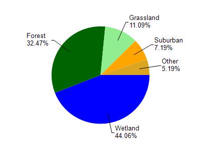
Pokegama River is located in the St. Louis and Lower Nemadji River watershed which is 159.67 mi². Land use in the watershed is primarily wetland (44.10%), forest (32.50%) and a mix of grassland (11.10%) and other uses (12.40%). This watershed has 432.66 stream miles, 8,490.75 lake acres and 26,945.85 wetland acres.
Nonpoint Source Characteristics
This watershed is ranked Not Ranked for runoff impacts on streams, Not Available for runoff impacts on lakes and Low for runoff impacts on groundwater and therefore has an overall rank of Low. This value can be used in ranking the watershed or individual waterbodies for grant funding under state and county programs.However, all waters are affected by diffuse pollutant sources regardless of initial water quality. Applications for specific runoff projects under state or county grant programs may be pursued. For more information, go to surface water program grants.