Dane
No
No
No
Fish and Aquatic Life
Overview
Lake Belle View is a shallow millpond on the Sugar River located in the Village of Belleville approximately 20 miles southwest of the Madison metropolitan area in Dane County. The 90 acre lake was formed in 1920 when the mill dam was constructed north of the village’s business district. Since then, the village has grown around the lake and considers the lake to be an important part of the community’s identity. Much of the area, particularly west and north of the lake is classified by DNR as functioning wetlands consisting of scrub-shrub and floodplain forests. Prior to the river/lake separation project (see below) the lake was considered hyper-eutrophic (excessively fertile), had very little aquatic vegetation (emergent or rooted), and large quantities of filamentous/benthic algae.
Historically, both the Upper Sugar River and West Branch Sugar River watersheds drained to the lake, an approximately 172 square mile drainage area. Land use consists of agricultural and rural residential development, as well as the rapidly growing area of Verona, the southwest side of Madison, and part of Mount Horeb. The Mount Horeb wastewater treatment plant and MMSD both have treated effluent discharges to the Sugar River, flowing through the lake. The Sugar River is considered a coldwater fishery above Frenchtown Road and a warmwater sport fishery below. The Sugar River downstream of the Lake Belle View dam has a very diverse cool water and warmwater sport fishery. The river is considered a state Exceptional Resource Water (ERW) from its headwaters in Dane County downstream to the Green-Rock county line.
Three specific problems have plagued Lake Belle View, typical of shallow millponds: sediment loading, high phosphorus levels, and a large carp population. The lake has also experienced problems with fecal coliform bacteria. Through the processes of erosion and runoff, soil originally located on the hillsides and fields of the Sugar River watershed has been washed into the the Sugar River and transported to the lake. In addition, cattle access to the river upstream trample stream banks, re-suspend riverbed sediment, and has contributed nutrient-rich manure to the lake. As urban development and agricultural production activities continue in the watershed, additional nutrients and sediment carried to the lake would continue. Once deposited in the lake, sediment would be constantly re-suspended by a large rough fish population dominated by carp. Wind-generated waves and turbulence made the problem worse. Due in part to these problems, recreational opportunities for swimming and boating have been historically diminished, game fish have been unable to establish themselves in the turbid water, undesirable odors have developed during the summer months, and the fishery of the Sugar River has also been negatively affected by the stagnant conditions in the lake.
After many years working with various federal, state, and local groups, the Village of Belleville initiated a River/Lake Restoration project in 2010 to help reverse the many years of abuse and neglect. Specific objectives of the restoration project include:
Improving water quality in both the lake and the river by re-routing the river channel around the former millpond to the west by means of a separation berm, reducing the amount of sediment and nutrients entering the lake as well as thermal impacts to the river;
Restoring a deep water sport fishery in the lake and providing opportunities for public recreation and appreciation by dredging approximately 400,000 cubic yards of sediment, creating a deeper lake area approximately 31 acres in size, as well as a pedestrian/bike trail along the top of the berm;
Enhancing and restoring floodplain forest and wetland habitat for wildlife and creating more diverse aquatic lake habitat and vegetation including planting, seeding, and stocking native plant and fish species.
The lake has since been dredged to a depth of 8-10 feet with the deepest part located near the community park. Some of the dredge material was used to enlarge existing islands for floodplain forest habitat enhancement and restoration. There is approximately 30 acres on the river side of the berm that will be restored to wetlands and upland habitat through native plantings and seeding. Vegetative response will be monitored closely during and after the project to make sure the right plants get established and invasive, aquatic nuisance plants are prevented from being established. Construction of the berm and dredging started in the fall of 2010. Vegetation and fishery restoration began in 2011, with vegetation diversity enhancement and tree planting expected in 2013. Monitoring of aquatic and terrestrial conditions will continue through 2020.
Overall, the project is expected to create a more defined riverine system adjacent to the lake, and the increased flow should improve the stagnant conditions experienced in the past. The project also proposes to restore nearby wetland areas to filter floodwaters and provide food and shelter for wildlife. This project is unique in its approach to the lake and river separation by maintaining both bodies of water while allowing the river to run continuously past the lake. This comprehensive project serves as a national model for other millponds and rivers in Wisconsin and the United States. The project provides an alternative to an "all or nothing" scenario typical of the past management considerations. Additional future project activities may include further deepening of a portion of the lake and construction of fish passage features to meet longer-term objectives.
Date 2012
Author Mike Kakuska
Historical Description
Source: 1985, Surface Water Resources of Dane County,WI: WI-DNR Lake Belle View (Belleville Millpond) - T5N, R8E, Sec. 34 Surface acres = 100, SDF = 2.45, Maximum depth = 7 ft A large, shallow impoundment of the Sugar River, Lake Belle View is located in the Village of Belleville. The lake is high in dissolved solids and water quality is poor. Problems stem from heavy sediment loads, turbidity, storm sewers, municipal and industrial effluents discharged upstream, and carp populations. Excessive macrophyte growth reduces its recreational potential. There is some private development on the-lake. Local residents enjoy fishing for white suckers in Lake Belle View. Panfish, largemouth bass, and in lesser numbers, smallmouth bass, channel catfish, and bullheads are also caught. A few walleye are stocked but have been unable to establish themselves. A city park in Belleville provides swimming, fishing, and boating opportunities. The park is a favorite starting point for boat trips on the Sugar River and a terminus for trips originating upstream. Fish species: common carp, golden shiner, common shiner, sandshiner, suckermouth minnow, bluntnose minnow, creek chub, silver, golden, and shorthead redhorse, orange spotted sunfish, bluegill, largemouth and smallmouth bass, black crappie, Johnny darter, mottled sculpin, black bullhead, channel catfish, and white sucker.
Date 1985
Author Surface Water Inventory Of Wisconsin
General Condition
Surface runoff from agricultural and urban areas in the Sugar River watershed has carried large loads of sediment and nutrients into Lake Belle View leading to substantial water quality issues. It is estimated that at least 4 feet of river-borne sediment has accumulated in the lake since 1926, resulting in a mean depth of 2 feet and a maximum depth of less than 6 feet. The Sugar River was estimated to deliver 59,800 pounds of phosphorus to Lake Belle View per year, which contributed to the poor water quality in the lake. Lake Belle View is a hyper-eutrophic lake that has suffered from water quality and fishery problems typically associated with aging impoundments including sedimentation, turbidity, lack of aquatic plant diversity, excessive nutrients and algal blooms. Excessive nutrient enrichment fuels benthic and planktonic algae that cause odor problems and reduced water clarity. Associated biological decay and oxygen reduction in the water has significantly reduced water quality in the lake and negatively affected the entire riverine ecosystem in this area.
The Wisconsin Tropic State Index (WTSI) indicates an average value of 68 between 2007 and 2008 indicating generally fair to poor water quality conditions. The public beach on Lake Belle View was closed after WDNR monitoring detected high fecal coliform bacteria levels throughout the 1970s. The quality of the river system is further reduced by the extensive warming of the water by the shallow turbid lake resulting in a warming of the Sugar River and thermal pollution downstream of the dam.
In addition, the slow and steady infiltration of sediment over many years has increased the amount of shallow water, contributing to habitat that only supports rough fish and environmentally tolerant invertebrates. The lake has been described as a “carp factory.” The prolific common carp population recruited within the millpond largely eliminated emergent, floating leaf, and submergent aquatic plants. In 1995 the Water Resource Management (WRM) Workshop through the University of Wisconsin - Madison conducted several surveys of the lake including vegetation and invertebrates. The results of those surveys show that species diversity was low in the lake itself, but downstream of the dam a more diverse macro invertebrate population existed. An aquatic plant survey contracted by the Village in 2009 noted the presence of only two rooted species, curly-leaf pondweed (an exotic) at 15.9% of the sites and sago pondweed at only 2.9% of the sites. In 1993 DNR fish sampling above the lake found 28 species, but in the lake the spawning areas for more desirable game fish species had been destroyed. Carp populations are not only a result of, but also contribute to the water quality problems in the lake through re-suspension of bottom sediments when scavenging.
Date
Author Mike Kakuska
Impaired Waters
Belleville Millpond (WBIC 886000) was listed for total phosphorus in 2016. The 2018 assessments showed continued impairment by phosphorus; new total phosphorus and chlorophyll sample data exceeded 2018 WisCALM listing thresholds for the Recreation use and Fish and Aquatic Life use. Based on the most updated information, no change in existing impaired waters listing is needed.
Date 2017
Author Ashley Beranek
Impaired Waters
This water was assessed during the 2016 listing cycle; total phosphorus sample data exceed 2016 WisCALM listing thresholds for the Recreation use and Fish and Aquatic Life use, chlorophyll data only exceed REC thresholds, not FAL.
Date 2015
Author Aaron Larson
Condition
Wisconsin has over 84,000 miles of streams, 15,000 lakes and milllions of acres of wetlands. Assessing the condition of this vast amount of water is challenging. The state's water monitoring program uses a media-based, cross-program approach to analyze water condition. An updated monitoring strategy (2015-2020) is now available. Compliance with Clean Water Act fishable, swimmable standards are located in the Executive Summary of Water Condition in 2018. See also the 'monitoring and projects' tab.
Reports
Recommendations
Comprehensive Planning Studies
Monitor Water Quality or Sediment
Habitat Restoration - Shoreland
Shoreland Restoration
Informational Meetings
routine public meetings and presentations about the entire project, which will be offered to the Wisconsin Association of Lakes, Water Resources Association and North American Lakes Management Society.
Monitor Fish Community
Lake Management Plan Implementation
The Village of Belleville proposes, as part of a whole-lake restoration project, to separate Lake Belle View from the Sugar River by construction of an earthen berm on the western side of the lake.
Lake Management Plan Development
The Village of Belleville proposes, as part of a whole-lake restoration project to restore, create, and protect rare forested floodplain habitat within the lake and adjoining area.
Lake Classification
Dane County Lake Classification-Phase 2: The Phase 1 classification grant classified all county lakes and streams. This grant will take the next step by developing a management program based on the classification.
Lake Classification
Dane County Department of Planning and Development will hire a project staff in order to develop a Lake Classification project, which is seen as the first step toward developing a consistent set of county-wide standards and procedures to protect Dane County Waters.
Management Goals
Wisconsin's Water Quality Standards provide qualitative and quantitative goals for waters that are protective of Fishable, Swimmable conditions [Learn more]. Waters that do not meet water quality standards are considered impaired and restoration actions are planned and carried out until the water is once again fishable and swimmable
Management goals can include creation or implementation of a Total Maximum Daily Load analysis, a Nine Key Element Plan, or other restoration work, education and outreach and more. If specific recommendations exist for this water, they will be displayed below online.
Monitoring
Monitoring the condition of a river, stream, or lake includes gathering physical, chemical, biological, and habitat data. Comprehensive studies often gather all these parameters in great detail, while lighter assessment events will involve sampling physical, chemical and biological data such as macroinvertebrates. Aquatic macroinvertebrates and fish communities integrate watershed or catchment condition, providing great insight into overall ecosystem health. Chemical and habitat parameters tell researchers more about human induced problems including contaminated runoff, point source dischargers, or habitat issues that foster or limit the potential of aquatic communities to thrive in a given area. Wisconsin's Water Monitoring Strategy was recenty updated.
Grants and Management Projects
Monitoring Projects
| WBIC | Official Waterbody Name | Station ID | Station Name | Earliest Fieldwork Date | Latest Fieldwork Date | View Station | View Data |
|---|
| 886000 | Lake Belle View | 10001250 | Lake Belle View | 7/27/1999 | 9/16/2020 | Map | Data |
| 886000 | Lake Belle View | 10034353 | Lake Belle View (Site B) | | | Map | Data |
| 886000 | Lake Belle View | 10020091 | Lake Belle View -- Boat Ramp | 7/12/2021 | 11/23/2022 | Map | Data |
| 875300 | Sugar River | 10020091 | Lake Belle View -- Boat Ramp | 7/12/2021 | 11/23/2022 | Map | Data |
| 886000 | Lake Belle View | 133317 | Lake Belle View - Deep Hole | 7/17/1980 | 9/13/2015 | Map | Data |
| 886000 | Lake Belle View | 10034967 | Lake Belle View - North Channel access from Hwy 69 | 9/14/2011 | 9/5/2013 | Map | Data |
| 886000 | Lake Belle View | 10021226 | Lake Belle View - Site 1 - Deep Hole - Near Main Sugar R Outlet | 6/3/2007 | 8/9/2025 | Map | Data |
|
Projects
After more than 30 years working with local, state, and federal interests, the Village of Belleville developed a restoration plan that met the varied use objectives among the various groups. The restoration project is currently being completed centered on the construction of a 3200-foot berm that separates the “new” lake from the river system. The berm serves to isolate the lake from the high nutrient and sediment loads in the Sugar River for all but the largest flood events. The berm also provides access to restored wetland areas and serves as a biking and hiking trail that connects the north part of the village to its southern business district. To meet federal and local floodplain regulations the separation berm has been designed to prevent river water intrusion under all but the most extreme flow events. To minimize costs and to expand a rare floodplain forest wetland, the lake’s open water area has been reduced in size, with sediment borrowed from lake dredging being used to restore the wetland system.
The 61 acre lake complex includes 31 acres of lake and deepwater wetland habitat, 12 acres of emergent wetland, and 18 acres of floodplain forest wetlands, providing numerous functional values and educational opportunities, especially along the hiking/biking trail on top of the berm. An estimated 99 percent of the phosphorus and sediment will bypass the lake, an important factor for sustaining the lake for decades to come. The dam which created Lake Belle View (the former Belleville Millpond), will remain in place, but groundwater seepage will be the method of refilling and maintaining the new lake, estimated to be approximately 1,100 acre-ft/yr. The lake has its own control system and over 30 different fish species have been stocked in the lake to provide a diverse, ecologically-based fish population.
The Lake Belle View restoration project has been designed to mimic a natural river floodplain lake that harbors many native fish, including largemouth bass and bluegill. Separation of the Sugar River and Lake Belle View will significantly reduce the amount of sediment and nutrients transported by the Sugar River to the lake, which will improve the overall water quality and increase the lifespan of any lake enhancement projects. In addition, the separation allows for more targeted fish management options, such as carp control, and the establishment of a desirable warm water fishery. Control of lake water levels at the former millrace structure allow for manipulation of water levels in the future as part of fish or habitat management, independent of flood or low flow condtions in the Sugar River. The benefits also include an increase in the available habitats for various wetland, upland, and migratory animals, and a powerful educational opportunity for the village and other interested parties in millpond management options.
Date 2012
Author Mike Kakuska
Watershed Characteristics
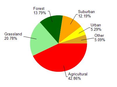
Lake Belle View is located in the Upper Sugar River watershed which is 105.96 mi². Land use in the watershed is primarily agricultural (42.90%), grassland (20.80%) and a mix of forest (13.80%) and other uses (22.60%). This watershed has 183.62 stream miles, 151.49 lake acres and 2,231.15 wetland acres.
Nonpoint Source Characteristics
This watershed is ranked High for runoff impacts on streams, Not Ranked for runoff impacts on lakes and High for runoff impacts on groundwater and therefore has an overall rank of High. This value can be used in ranking the watershed or individual waterbodies for grant funding under state and county programs.However, all waters are affected by diffuse pollutant sources regardless of initial water quality. Applications for specific runoff projects under state or county grant programs may be pursued. For more information, go to surface water program grants.