Dane
Yes
No
No
Fish and Aquatic Life
Overview
German Valley Branch is a seven-mile spring fed stream in Dane County on the south slope of Military Ridge that joins Big Spring Creek (also known as Blue Mounds Branch) to form Gordon Creek. Its designated use has not been
codified. Although this entire stream is on the state’s list of impaired waters due to habitat degradation caused by heavy sedimentation, German Valley has shown signs of improvement over the last several years, and is now
considered to be meeting its designated use. As such, German Valley Branch, along with Syftestad Creek, serve as a reference stream for these TMDLs.
Previously, under its impaired condition, German Valley Branch only supported a warm water forage fishery. Recent monitoring indicates that the stream now supports a cold water fish community including abundant mottled sculpin, numerous brown trout that migrate upstream from Gordon Creek and American brook lamprey.
German Valley Creek is currently managed as a Class II trout stream but fisheries and water quality reclassification submittals are pending approval. Surveys conducted in 2001 and 2002 showed water temperatures that stayed below 75 F and dissolved oxygen stayed above 6.0 mg/l, even during rain events. Fish shocking conducted in that same year at CTH Z showed several year classes of brown trout as well as the presence of other cold water species such as mottled sculpin and American brook lamprey. In conjunction with biological sampling data, WDNR biologists made visual observations in 2002 regarding the stream. They noted that the bottom consisted of rock and rubble with areas of sediment deposition,
and that the stream was narrow.
According to Department habitat ratings, these observations suggest fair habitat. The Cold Water Index of Biotic Integrity (CWIBI) for this survey was 50, which indicates a “fair” assemblage of coldwater species. This improvement may be due to the large enrollment of upstream lands in the Conservation Reserve Program (CRP). There is an ongoing project on German Valley Branch to rehabilitate the stream corridor to mitigate the effects of sediment from nonpoint sources and improve fish habitat. Such efforts will continue through 2005.
Date 2006
Author Aquatic Biologist
Historical Description
German Valley Creek -T5N, R6E, Sec. 6, Surface acres = 1.5, Length = 5 mIles, Stream order = II, Gradient = 36.0 ft/mile.
Base discharge = 0.19 cfs.
ThIs small. sprlng-fed stream on the south slope of Military Ridge joins the Blue Mounds Branch near the lowa-Dane County line to form Gordon Creek. ApproxImately 130 acres of pastured fresh meadow adjoin the stream near the mouth. Watershed problems include severe stream bank erosIon, overgrazing. and agricultural runoff. The stream presently supports a good dIversity of forage fish. A trout fishery could be established through an intensive habitat and watershed management program. Access is available at six road crossings. Fish species: brook lamprey, central stoneroller, blacknose dace, creek chub, white sucker, brook stickleback, and Johnny darter.
From: Day Elizabeth A.; Grzebieniak, Gayle P.; Osterby, Kurt M.; and Brynildson, Clifford L., 1985. Lake and Stream Classification Project. Surface Water Resources of Dane County, Wisconsin Department of Natural Resources, Madison, WI
Date 1985
Author Surface Water Inventory Of Wisconsin
General Condition
German Valley Branch (WBIC 909200) was assessed during the 2018 listing cycle; new biological (fish Index of Biotic Integrity (IBI) scores) sample data were clearly below the 2018 WisCALM listing thresholds for the Fish and Aquatic Life use. This water was meeting this designated use and was not considered impaired.
Date 2017
Author Ashley Beranek
General Condition
German Valley Creek arises in Section 10 of Blue Mounds Township and flows about seven miles to the confluence with Gordon Creek. Until recently, GVC had never been managed for trout due to chronic low stream flows, poor habitat and poor water quality. However, while it has been more degraded than Gordon Creek, German Valley Creek followed a similar path toward restoration (Figure 6). GVC now supports primarily stenothermal cold water fish species and the trout stream classification reflects these fish community changes and angler opportunities.
Surveys completed from 2007 through 2009 demonstrate continued favorable trout habitat. Several miles of the stream habitat was restored and include easements for public fishing. GVC is still listed as 303d impaired by it is expected to be removed from the list soon to reflect the significantly improved water quality and habitat and sustained brown trout population. And Dane County Department of Land and Water Resources continue to work with area farmers to improve manure management practices. The best trout habitat is located in the lower reaches where enough spring flow sustains habitat and cold water temperatures. Hilsenhoff Biotic Index scores ranged from 2.91 (excellent water quality) to 5.15 (good water quality) during the period from 1994 through 2002.
Date 2011
Author Carpc Capital Area Rpc
General Condition
This spring-fed stream on the south slope of Military Ridge joins Big Spring Creek (also known as Blue Mounds Branch) to form Gordon Creek. Although this stream is on the state's list of impaired waters due to habitat degradation caused by heavy sedimentation, German Valley has shown signs of improvement over the last several years.
Surveys conducted in 2001 and 2002 showed water temperatures stayed below 75oF and dissolved oxygen stayed above 6.0 mg/l, even during rain events, thus it is has the potential to support trout. Fish shocking conducted in that same year showed several year classes of brown trout as well as the presence of other cold water species such as mottled sculpin and brook lamprey (Marshall, pers comm). This improvement may be due to the large enrollment of upstream lands in the Conservation Reserve Program (CRP).
Date 2002
Author James Amrhein
Condition
Wisconsin has over 84,000 miles of streams, 15,000 lakes and milllions of acres of wetlands. Assessing the condition of this vast amount of water is challenging. The state's water monitoring program uses a media-based, cross-program approach to analyze water condition. An updated monitoring strategy (2015-2020) is now available. Compliance with Clean Water Act fishable, swimmable standards are located in the Executive Summary of Water Condition in 2018. See also the 'monitoring and projects' tab.
Reports
Recommendations
Control Streambank Erosion
German Valley Creek Middle - Installation of streambank restoration and protection practices. Each stream has had major rehabilitation of the watershed and stream corridor. The water quality objective of the project was to reduce stream bank erosion by 90% resulting in an overall reduction of sediment load of over 7300 tons/year over the whole area of the project. In all, almost 50,000 feet of stream bank was shaped and stabilized, and over 600 fish habitat structures (LUNKERS and weirs) were added to the stream.
Rivers Planning Grant
This project seeks a river planning grant to support this community based conservation effort which will increase community awareness of river protection issues and maximize landowner participation in conservation programs, ultimately protecting and improving streams, grassland bird habitats and the ecosystem of the Military Ridge region.
Management Goals
Wisconsin's Water Quality Standards provide qualitative and quantitative goals for waters that are protective of Fishable, Swimmable conditions [Learn more]. Waters that do not meet water quality standards are considered impaired and restoration actions are planned and carried out until the water is once again fishable and swimmable
Management goals can include creation or implementation of a Total Maximum Daily Load analysis, a Nine Key Element Plan, or other restoration work, education and outreach and more. If specific recommendations exist for this water, they will be displayed below online.
Monitoring
Monitoring the condition of a river, stream, or lake includes gathering physical, chemical, biological, and habitat data. Comprehensive studies often gather all these parameters in great detail, while lighter assessment events will involve sampling physical, chemical and biological data such as macroinvertebrates. Aquatic macroinvertebrates and fish communities integrate watershed or catchment condition, providing great insight into overall ecosystem health. Chemical and habitat parameters tell researchers more about human induced problems including contaminated runoff, point source dischargers, or habitat issues that foster or limit the potential of aquatic communities to thrive in a given area. Wisconsin's Water Monitoring Strategy was recenty updated.
Grants and Management Projects
Monitoring Projects
| WBIC | Official Waterbody Name | Station ID | Station Name | Earliest Fieldwork Date | Latest Fieldwork Date | View Station | View Data |
|---|
| 909200 | German Valley Br | 10011871 | German Valley Br - Grundahl Property Driveway Upstream 75 M To End | | | Map | Data |
| 909200 | German Valley Br | 10015878 | German Valley - 30 Feet Upstream From Bridge Across From 2099 Cth E | 6/5/1986 | 6/18/2024 | Map | Data |
| 909200 | German Valley Br | 10011865 | German Valley Br - Cty. Rd. Z Bridge | 1/1/2015 | 6/18/2024 | Map | Data |
| 909200 | German Valley Br | 10011868 | German Valley Br - 45 M Above Mayflower Rd. Upstream 105 M To End | 5/11/1994 | 4/17/2002 | Map | Data |
| 909200 | German Valley Br | 10012863 | German Valley Branch - Cth Z | 1/1/2015 | 5/23/2026 | Map | Data |
| 909200 | German Valley Br | 10031449 | German Valley Branch 200 m S of County E .5 mile SW of Mayflower Rd. | 7/19/2010 | 1/1/2015 | Map | Data |
| 909200 | German Valley Br | 10011867 | German Valley Br - Middle Farm Field Center Of Station # 2 | 11/1/2001 | 11/1/2001 | Map | Data |
| 909200 | German Valley Br | 10054044 | German Valley Br @ HWY E North of Fertile Ridge Rd | | | Map | Data |
| 909200 | German Valley Br | 10011866 | German Valley Br - along Cty. Rd. E upstream of N. Perry Rd. | 1/1/2015 | 1/1/2015 | Map | Data |
| 909200 | German Valley Br | 10011870 | German Valley Br upstream of Cty. Rd. E Bridge (South) (Sec. 28) | 1/1/2015 | 1/1/2015 | Map | Data |
| 909200 | German Valley Br | 10011872 | German Valley Br - Cty. Rd. E Bridge (North) Upstream 101 M To End | 11/1/2001 | 1/1/2015 | Map | Data |
| 909200 | German Valley Br | 133488 | Farm Field Runoff - Cth E Just South Of Hwy 151 | 3/21/2005 | 8/6/2025 | Map | Data |
| 909200 | German Valley Br | 10029195 | German Valley Branch ~800m US of Mayflower Rd bridge | 10/7/2009 | 1/1/2015 | Map | Data |
| 909200 | German Valley Br | 10029196 | German Valley at upper Kahl stream crossing | 1/1/2015 | 1/1/2015 | Map | Data |
| 909200 | German Valley Br | 10014242 | German Valley Branch-N. Perry Rd. Bridge Upstream 357 M To End | 1/1/2015 | 6/18/2024 | Map | Data |
| 909200 | German Valley Br | 10011869 | German Valley Br - Cty. Rd. E Bridge Upstream 150 M To End | 11/1/2001 | 6/18/2024 | Map | Data |
| 909200 | German Valley Br | 10012862 | German Valley Branch - Mayflower Rd | 4/22/2005 | 6/18/2024 | Map | Data |
|
Watershed Characteristics
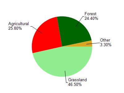
German Valley Br is located in the Gordon Creek watershed which is 76.90 mi². Land use in the watershed is primarily grassland (46.50%), agricultural (25.80%) and a mix of forest (24.40%) and other uses (3.30%). This watershed has 205.79 stream miles, 7.11 lake acres and 487.25 wetland acres.
Nonpoint Source Characteristics
This watershed is ranked High for runoff impacts on streams, Not Ranked for runoff impacts on lakes and High for runoff impacts on groundwater and therefore has an overall rank of High. This value can be used in ranking the watershed or individual waterbodies for grant funding under state and county programs.However, all waters are affected by diffuse pollutant sources regardless of initial water quality. Applications for specific runoff projects under state or county grant programs may be pursued. For more information, go to surface water program grants.