Clark, Eau Claire
No
No
Yes
Fish and Aquatic Life
Overview
The North Fork of the Eau Claire River originates in southwestern Taylor County. It flows for approximately 48 miles before joining up with the South Fork in Eau Claire County. The South Fork of the Eau Claire River originates in northwestern Clark County and is approximately 40 miles in length. The main stem of the Eau Claire River flows in a westerly direction for approximately 34 miles before emptying into the Chippewa River in the City of Eau Claire. The Eau Claire County Forest lies along the majority of the river’s main stem. The Clark County Forest lies along approximately the lower five miles of the South and North Forks.
Voss, Karen and Sarah Beaster. 2001. The State of the Lower Chippewa River Basin. PUBL-WT-554 2001. Wisconsin Department of Natural Resources, Madison, WI.
Date 2001
Author Karen Voss
Historical Description
The North Fork of the Eau Claire River begins in Taylor County. Habitat degradation due to streambank pasturing has been noted, as well as low dissolved oxygen levels, particularly during low-flow conditions. In Taylor County, many river locations have no flow in the fall (Water Resources Management, Fisheries Management). Water quality sampling near the river mouth produced dissolved oxygen data ranging from 7.2 to 14.2 mg/l. The water quality standard for surface waters is 5 mg/l. The water was observed to be brown and turbid during high flows (Hazuga).
Monitoring in the vicinity of Eidsvold during the winter of 1990, documented under-ice river oxygen values as low as 3.6 mg/l, which is below the water quality standard of 5 mg/l. Monitoring during the drought of 1988 found daily oxygen fluctuations down to 3 mg/l (LaLiberte 1990). Since no point source discharges or surface water runoff occurred during the monitoring, the oxygen problem had to be the result of natural aeration insufficient to offset sediment oxygen demand. The river has a very weak base flow in this reach (LaLiberte 1994). The Lublin wastewater treatment plant discharges to a dry run tributary to the North Fork. Discharges from the two-cell stabilization pond system are only authorized in spring and fall. The permit sets maximum discharge rates for each month. A stream study would verify if the discharge rates are appropriate. The discharge is below the 150-pound-per-month threshold for requiring phosphoms removal under Mi 217.
The Thorp wastewater treatment plant discharges treated wastewater only in the spring and fall with the discharge rate proportional to stream flow. River oxygen levels have not been monitored in the spring. Spring oxygen and temperature data are needed to confirm that the river oxygen levels assumed to exist during effluent limit development are correct. The stream oxygen, temperature and macroinvertebrate data collected since the Thorp discharge began has not been evaluated (LaLiberte 1994). Raber Foods discharges treated wastewater intermittently to a wetland tributary to the North Fork Eau Claire River. In 1986 the wetland was classified as capable of supporting marginal aquatic life, and the tributary as capable of supporting intermediate aquatic life due to the presence of a reproducing forage fishery (LaLiberte 1986).
Date 1996
Author Paul Laliberte
Historical Description
A medium hard water, light brown colored stream that flows south and then west into Eau Claire County where it joins the south fork to form the main Eau Claire River. Muskellunge and smallmouth bass are the primary sport fish. About 75 percent of the watershed area in Clark County has been cleared and 25 percent is wooded or wild. Waterfowl and furbearers are present. There are 15 miles of public frontage (forest cropland). Access is possible from nine road crossings. Light boat traffic is possible (especially in the lower portion of the stream), but portages are frequent except during high water conditions.
North fork of Eau Claire River T27N, R4W, S18, Surface Acres = 75.6, Miles = 24.0, Gradient = 7.5 feet per mile.
From: Klick, Thomas A. and C.W. Threinen, 1965. Surface Water Resources of Clark County: Lake and Stream Classification Project. Wisconsin Conservation Department, Madison, WI.
Date 1965
Author Surface Water Inventory Of Wisconsin
General Condition
The North Fork of the Eau Claire River is a 56 mile warm water sport fishery. Recent surveys in Clark and Eau Claire Counties found a very diverse fishery and smallmouth bass were the dominant game fish. Multiple year classes of smallmouth bass were found throughout the river, however lower densities are typically found in central Clark County.
The river in this reach lacks deep water habitat for smallmouth bass especially during low flow periods and there is a greater accumulation of fine sediments in this section. Grab water chemistry sampling on the North Fork Eau Claire indicates total phosphorus concentrations are highest in central Clark County and are nearly 3 times higher than the proposed water quality standard. Nonpoint source runoff is the primary contributor of sediment and nutrients to the river.
Date 2010
Author Paul Laliberte
Impaired Waters
The 2018 assessments of the North Fork Eau Claire River showed impairment by phosphorus; new total phosphorus sample data at the above (Assessment Unit (AU) 6923457) and below (AU 16146) stream segments exceed 2018 WisCALM listing criteria for the Fish and Aquatic Life use. However, available biological data do not indicate impairment (i.e. no macroinvertebrate or fish Index of Biotic Integrity (IBI) scored in the "poor" condition category). Based on the most updated information, this water segment of the N Fk Eau Claire River (this AU: Wolf River to Sterling Creek) was proposed for the impaired waters list.
Date 2017
Author Ashley Beranek
Impaired Waters
Multiple segments of the North Fork Eau Claire River were assessed in 2018: Mouth to Wolf River (miles 0-10.49); Sterling Creek to headwaters (miles 22.48-53.91). The 2018 assessments of the North Fork Eau Claire River showed impairment by phosphorus; new total phosphorus sample data exceeded the 2018 WisCALM listing criteria for the Fish and Aquatic Life use, however, available biological data did not indicate impairment (i.e. no macroinvertebrate or fish Index of Biotic Integrity (IBI) scored in the "poor" condition category). Based on the most updated information, this water was proposed for the impaired waters list.
Date 2017
Author Ashley Beranek
Condition
Wisconsin has over 84,000 miles of streams, 15,000 lakes and milllions of acres of wetlands. Assessing the condition of this vast amount of water is challenging. The state's water monitoring program uses a media-based, cross-program approach to analyze water condition. An updated monitoring strategy (2015-2020) is now available. Compliance with Clean Water Act fishable, swimmable standards are located in the Executive Summary of Water Condition in 2018. See also the 'monitoring and projects' tab.
Reports
Recommendations
Water Quality Planning
Project: North Fork Eau Claire (LC17) Watershed Planning
Lake Management Plan Implementation
Reduce phosphorus loading to reduce excessive algae growth in Lakes Eau
Claire and Altoona. Implement key best management practices on agricultural
lands in the upper portion of this watershed for phosphorus control.
Water Quality Planning
Complete land use modeling report and use the results to better direct BMP
selection in all contributing watersheds.
Trout Classification Mgmt
Trout stream classifi cations of some streams may need to be changed as a result of the additional monitoring
identifi ed above.
Monitor Baseline Survey
Stream assessment monitoring should be completed on Swim, Sterling, Shambaugh, Loper and Beeman Creeks
to determine appropriate stream classifi cations. These streams are classifi ed as trout water even though historic
data does not support a cold water designation or data does not exist.
Wastewater Monitoring or Management
WDNR should collect spring oxygen and temperature data on the North
Fork of the Eau Claire River for verification of Thorp treatment plant effluent
limits (Type B).
Management Goals
Wisconsin's Water Quality Standards provide qualitative and quantitative goals for waters that are protective of Fishable, Swimmable conditions [Learn more]. Waters that do not meet water quality standards are considered impaired and restoration actions are planned and carried out until the water is once again fishable and swimmable
Management goals can include creation or implementation of a Total Maximum Daily Load analysis, a Nine Key Element Plan, or other restoration work, education and outreach and more. If specific recommendations exist for this water, they will be displayed below online.
Monitoring
Monitoring the condition of a river, stream, or lake includes gathering physical, chemical, biological, and habitat data. Comprehensive studies often gather all these parameters in great detail, while lighter assessment events will involve sampling physical, chemical and biological data such as macroinvertebrates. Aquatic macroinvertebrates and fish communities integrate watershed or catchment condition, providing great insight into overall ecosystem health. Chemical and habitat parameters tell researchers more about human induced problems including contaminated runoff, point source dischargers, or habitat issues that foster or limit the potential of aquatic communities to thrive in a given area. Wisconsin's Water Monitoring Strategy was recenty updated.
Grants and Management Projects
Monitoring Projects
| WBIC | Official Waterbody Name | Station ID | Station Name | Earliest Fieldwork Date | Latest Fieldwork Date | View Station | View Data |
|---|
| 2145400 | North Fork Eau Claire River | 10030169 | North Fork Eau Claire River at CTH MM | 7/14/2009 | 10/23/2018 | Map | Data |
| 2145400 | North Fork Eau Claire River | 10010402 | N. Fork Eau Claire River 1 .5 mile S of CTH H and CTH MM | 5/6/1980 | 10/23/2018 | Map | Data |
| 2145400 | North Fork Eau Claire River | 183066 | Eau Claire River - Twn Rd Sec. 13 14 | | | Map | Data |
|
Watershed Characteristics
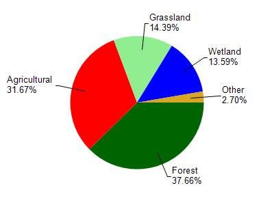
North Fork Eau Claire River is located in the North Fork Eau Claire River watershed which is 205.88 mi². Land use in the watershed is primarily forest (37.70%), agricultural (31.70%) and a mix of grassland (14.40%) and other uses (16.30%). This watershed has 411.76 stream miles, 302.30 lake acres and 18,394.61 wetland acres.
Nonpoint Source Characteristics
This watershed is ranked Low for runoff impacts on streams, Not Ranked for runoff impacts on lakes and High for runoff impacts on groundwater and therefore has an overall rank of High. This value can be used in ranking the watershed or individual waterbodies for grant funding under state and county programs.However, all waters are affected by diffuse pollutant sources regardless of initial water quality. Applications for specific runoff projects under state or county grant programs may be pursued. For more information, go to surface water program grants.