Brown
No
No
Yes
Fish and Aquatic Life
Overview
The East River travels north through Brown County and roughly parallel to the Fox River. The majority of the stream flows through agricultural lands, then through the urban areas of Allouez, De Pere and Green Bay before discharging into the Fox River. The lower seven miles of the East River is effected by a seiche effect from Green Bay. The seiche effect tends to keep sediment suspended in the water column. This 39-mile river has very hard water and is very turbid. Stream bank cover is very poor, many of the banks are pastured and are highly eroded. Significant amounts of agricultural fertility are added to the stream from pasturing and enriched runoff. The stream bottom consists of silt and clay. Instream cover is sparse and aquatic invertebrates scarce. Stream habitat assessment surveys indicate poor to good habitat and macroinvertebrate studies indicate poor to fair water quality. Many storm sewers discharge to the lower stretch of river creating higher velocities and turbid water. Data from a USGS monitoring operated at Monroe Street (Green Bay) during 1986 was used to estimate a sediment loading rate of 125 Tons/mi2/yr and a total phosphorus loading rate of 1,128 lbs/mi2/yr. Water chemistry data showed this area to be in a degraded state with BOD-5 load levels of 11 milligrams per liter (mg/l), total phosphorus levels of 1.91 mg/l, fecal streptococcus levels of 730,000 colonies/100 milliliter (ml) and fecal coliform levels of 1,410,000 colonies/100 ml. There are three point source facilities which discharge treated wastewater (one industrial and two municipal facilities-please refer to the point source tables for the East River Watershed for more information). Recent fisheries surveys indicate that northern pike utilize the marshy areas of the river located in Bellevue for spring spawning. Walleye, smallmouth bass, largemouth bass and yellow perch are found in the lower four miles of the East River.
Bougie, Cheryl A. 1999. Lower Fox River Basin Water Quality Management Plan. Public Review Draft. Wisconsin Department of Natural Resources, Madison, WI.
Date 1999
Author Cheryl Bougie
Impaired Waters
East River, from its mouth to unnamed tributary (119300) (miles 0 to 14.15) and from unnamed tributary (119300) to headwaters (miles 14.15 to 42.25), was put on the Impaired Waters List for phosphorus, suspended solids, and unspecified metals during the 1998 cycle. This river was evaluated every two-year cycle from 2014 to 2022; high phosphorus levels were confirmed. This water is part of the Lower Fox River Basin TP and TSS TMDL, approved in 2012.
Date 2022
Author Ashley Beranek
Condition
Wisconsin has over 84,000 miles of streams, 15,000 lakes and milllions of acres of wetlands. Assessing the condition of this vast amount of water is challenging. The state's water monitoring program uses a media-based, cross-program approach to analyze water condition. An updated monitoring strategy (2015-2020) is now available. Compliance with Clean Water Act fishable, swimmable standards are located in the Executive Summary of Water Condition in 2018. See also the 'monitoring and projects' tab.
Reports
Recommendations
TMDL Development
This proposal will help County staff implement actions related to the Clean Water Act and DNR?s targeted performance standards for nonpoint source pollution.
TMDL Implementation
Identify Targeted Best Management Practices locations
Navigability Determination
; East River;
Navigability Determination
; East River;
Navigability Determination
; East River;
Navigability Determination
; East River;
Navigability Determination
SW NE S10 T22N R20E; East River;
Nine Key Element Plan
Upper East River PWS Plan - Nine Key Element Plan - The East River watershed is further divided into two subwatersheds the Upper and Lower East River Watersheds. The Upper East River Watershed drains approximately 22,992 acres. Excessive sediment loads and increased algal blooms in the Lower Fox River and Bay of Green Bay prompted the need for action to be taken in the Lower Fox River Basin.
Sewer Service Area Planning
Brown County Planning Commission (BCPC) will contract directly with the Wisconsin Department of Natural Resources (WDNR) for services to be provided as set forth in the work program for 2015.
Nine Key Element Plan
East River PWS Plan - Nine Key Element Plan -The East River Priority Watershed Project plan assesses the rural and urban nonpoint sources of pollution in the East River Watershed Project area and guides the implementation of nonpoint source control measures. These control measures are needed to meet specific water resource objectives for the East River and its tributaries and for lower Green Bay.
TMDL (USEPA) Approved
Lower Fox River Basin TP TSS TMDL 2012
Sewer Service Area Planning
Brown County Planning Commission should continue updating and amending the Brown County Sewerage Plan (SSA Plan) on an as needed basis to prevent development in unsuitable areas (environmental sensitive areas) and protect surface and ground water quality (Type B).
Management Goals
Wisconsin's Water Quality Standards provide qualitative and quantitative goals for waters that are protective of Fishable, Swimmable conditions [Learn more]. Waters that do not meet water quality standards are considered impaired and restoration actions are planned and carried out until the water is once again fishable and swimmable
Management goals can include creation or implementation of a Total Maximum Daily Load analysis, a Nine Key Element Plan, or other restoration work, education and outreach and more. If specific recommendations exist for this water, they will be displayed below online.
Monitoring
Monitoring the condition of a river, stream, or lake includes gathering physical, chemical, biological, and habitat data. Comprehensive studies often gather all these parameters in great detail, while lighter assessment events will involve sampling physical, chemical and biological data such as macroinvertebrates. Aquatic macroinvertebrates and fish communities integrate watershed or catchment condition, providing great insight into overall ecosystem health. Chemical and habitat parameters tell researchers more about human induced problems including contaminated runoff, point source dischargers, or habitat issues that foster or limit the potential of aquatic communities to thrive in a given area. Wisconsin's Water Monitoring Strategy was recenty updated.
Grants and Management Projects
Monitoring Projects
| WBIC | Official Waterbody Name | Station ID | Station Name | Earliest Fieldwork Date | Latest Fieldwork Date | View Station | View Data |
|---|
| 118000 | East River | 053404 | Bellin Hospital 004 | | | Map | Data |
| 118000 | East River | 10058286 | East River | 7/9/2024 | 7/9/2024 | Map | Data |
| 118000 | East River | 10047190 | East River 60 meters US Ledgeview Road | 1/1/2015 | 9/15/2016 | Map | Data |
| 118100 | Baird Creek | 053225 | Schreiber Cheese Co Grn Bay 002 | | | Map | Data |
| 118000 | East River | 10043279 | East River at Harold Lewis Trail off Main Street | 1/1/2015 | 7/7/2026 | Map | Data |
| 118000 | East River | 10015770 | East River - 100 Yds. Downstream From Hwy 32 Bridge. | | | Map | Data |
| 118000 | East River | 10042799 | East River-Elkay Ln. | 4/3/2014 | 3/17/2016 | Map | Data |
| 118100 | Baird Creek | 053078 | Ellis Creek atlas Warehse And Cold Stor Gr Bay | 3/29/1978 | 3/29/1978 | Map | Data |
| 118000 | East River | 10039130 | East River at HWY 172 | | | Map | Data |
| 118000 | East River | 10032756 | East River at RR bridge Allouez | | | Map | Data |
| 118000 | East River | 10042854 | East River at Meyer Park at Kurtz Ave | 9/13/2014 | 8/17/2019 | Map | Data |
| 118000 | East River | 10036063 | East River - Area of Open Water | 6/24/2010 | 8/21/2011 | Map | Data |
| 118000 | East River | 10047019 | AOI-IBI East River Mile 3 | | | Map | Data |
| 118000 | East River | 053407 | Bellin Hospital 007 | | | Map | Data |
| 118000 | East River | 10042855 | East River at East River Trail Bridge | 9/13/2014 | 8/29/2015 | Map | Data |
| 118000 | East River | 053403 | Bellin Hospital 003 | | | Map | Data |
| 118000 | East River | 053401 | Bellin Hospital 001 | | | Map | Data |
| 118000 | East River | 10054010 | East River, East River Trail Near Amy ST and John ST | 8/15/2020 | 8/15/2020 | Map | Data |
| 118000 | East River | 053675 | East River - Hwy G | 3/26/2002 | 6/24/2026 | Map | Data |
| 118000 | East River | 10047189 | East River 100 meters DS Hoffman Road | 1/1/2015 | 9/19/2016 | Map | Data |
| 117900 | Fox River | 10058286 | East River | 7/9/2024 | 7/9/2024 | Map | Data |
| 118000 | East River | 10015767 | East River - 100 Yds. Downstream From Hwy 32 Bridge. | 4/23/1986 | 4/23/1986 | Map | Data |
| 118000 | East River | 10042853 | East River at Green Isle Park Trail Allouez | 9/13/2014 | 9/16/2025 | Map | Data |
| 118000 | East River | 10047186 | East River 30 meters US CTH X | 1/1/2015 | 9/15/2016 | Map | Data |
| 118000 | East River | 10045187 | Phragmites Occurrence - East River at Green Isle Park Trail, Allouez | | | Map | Data |
| 118000 | East River | 10047017 | AOI-IBI East River Mile 1 | 6/25/2020 | 8/15/2020 | Map | Data |
| 118000 | East River | 053402 | Bellin Hospital 002 | | | Map | Data |
| 118000 | East River | 053406 | Bellin Hospital 006 | 5/19/1939 | 6/1/1939 | Map | Data |
| 118000 | East River | 10047016 | AOC-IBI East River Mile 0 | | | Map | Data |
| 118000 | East River | 10047018 | AOI-IBI East River Mile 2 | 6/25/2020 | 8/15/2020 | Map | Data |
| 118000 | East River | 10048822 | East River @ DeKeyser pike project | 4/24/2017 | 4/27/2020 | Map | Data |
| 118000 | East River | 053118 | East River - A Monroe St Brg Green Bay | | | Map | Data |
| 118100 | Baird Creek | 10058286 | East River | 7/9/2024 | 7/9/2024 | Map | Data |
| 118300 | Unnamed | 10058286 | East River | 7/9/2024 | 7/9/2024 | Map | Data |
| 118000 | East River | 053405 | Bellin Hospital 005 | | | Map | Data |
|
Watershed Characteristics
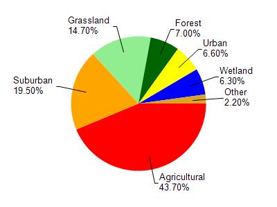
East River is located in the East River watershed which is 206.32 mi². Land use in the watershed is primarily agricultural (43.70%), suburban (19.50%) and a mix of grassland (14.70%) and other uses (22.10%). This watershed has 432.18 stream miles, 7,625.39 lake acres and 6,193.00 wetland acres.
Nonpoint Source Characteristics
This watershed is ranked High for runoff impacts on streams, Not Available for runoff impacts on lakes and High for runoff impacts on groundwater and therefore has an overall rank of High. This value can be used in ranking the watershed or individual waterbodies for grant funding under state and county programs.However, all waters are affected by diffuse pollutant sources regardless of initial water quality. Applications for specific runoff projects under state or county grant programs may be pursued. For more information, go to surface water program grants.