Brown
No
No
Yes
Fish and Aquatic Life
Overview
Baird Creek is a subwatershed draining 25 square miles in the northeast corner of the East River watershed. The creek is 31.1 miles long originating in agricultural lands to flow east through wetland, park and urban areas. The lower 3.5 miles is perennial and classified as FAL-B ( warm water sport fish communities) with the upper 27.6 miles of intermittent stream designated as FAL-C warm water forage fish.
The predominate land use in the upper reaches of the watershed is agriculture but is quickly being altered to urban as the population of the Green Bay metropolitan area spreads eastward. The subwatershed is unique in that a large portion (330 acres) along the stream corridor within the City of Green Bay has been designated as park land which includes the 270 acre Baird Creek Parkway with hiking and bicycling trails. The parkway is a mix of City, County, nonprofit and private ownership. The City of Green Bay is currently in the process of formalizing the parkway plan as a part of it’s new comprehensive land use planning process.
Date 2006
Author James Reyburn
General Condition
Baird Creek, a 13.1 mile stream which originates in agricultural lands then travels east through wetland, park and urban areas. The creek becomes urban as it joins the East River in Green Bay. The upstream clarity of this stream differs considerably from the turbid waters downstream where many storm sewers discharge to the stream. Walleye are known to migrate up Baird Creek during spring spawning. The creek supports a warm water forage fishery as well as a warm water sport fishery. Stream habitat assessment surveys indicate poor to fair habitat and macroinvertebrate studies indicate very good to poor water quality. In a 1985 survey of Baird Creek, the Redside Dace, a Wisconsin Watch Species, was found (Meyers, 1998).
In general water quality ranges from good in the upper reaches to poor in the lower urban reaches. The stream suffers from nonpoint rural and urban storm water, barnyard runoff, stream bank and cropland erosion causing turbidity, and nutrient problems as well as sedimentation and habitat loss. Historic stream habitat assessment surveys indicate poor to fair habitat and macroinveribrate studies indicate very good to poor water quality (WI DNR 1999).
Date 2006
Author James Reyburn
Impaired Waters
Baird Creek from its mouth to east of highway 43 (miles 0 to 3.5) was listed in the 2006 cycle due to elevated levels of phosphorus and sediment/TSS causing low dissolved oxygen and degraded habitat. Evaluations every two-year cycle from 2016 to 2022 confirmed the phosphorus impairment.
Baird Creek from east of highway 43 to its headwaters (miles 3.5 to 13.1) was listed in the 2008 cycle due to elevated levels of phosphorus and sediment/TSS causing low dissolved oxygen and degraded habitat. Evaluation in the 2012 cycle for phosphorus confirmed the impairment.
Date 2022
Author Ashley Beranek
Condition
Wisconsin has over 84,000 miles of streams, 15,000 lakes and milllions of acres of wetlands. Assessing the condition of this vast amount of water is challenging. The state's water monitoring program uses a media-based, cross-program approach to analyze water condition. An updated monitoring strategy (2015-2020) is now available. Compliance with Clean Water Act fishable, swimmable standards are located in the Executive Summary of Water Condition in 2018. See also the 'monitoring and projects' tab.
Reports
Recommendations
Monitor Water Quality or Sediment
Flow data is needed along with in-stream water quality parameters (nutrients and suspended solids) to determine effectiveness of TMDL implementation in the Baird Creek Watershed. This has been funded the past 3 years through 319 funds. Data will be used to support Brown County efforts and assess water quality for Integrated Reporting Process.
TMDL Implementation
2.7 miles of additional buffers were added to the Baird Creek watershed in 2011. This gage is the only active gage in the area that can help determine effectiveness of BMPs installed in this watershed as part of TMDL implementation efforts in Brown County.
Control Streambank Erosion
Buffer Strip installation in key sections of Baird Creek watershed to reduce agriculture nutrient, sediment and pesticide loading to Baird Creek & ultimately the Lower Fox River & Bay of Green Bay.
Educate and engage residents
The Baird Creek Preservation Foundation proposes to conduct a project called Community, Education, and Involvement Program. This is a capacity building effort to increase membership, member retention, member satisfaction and volunteer activity. This will be accomplished by issuing 3 newsletters/year, sponsoring 3-5 community events, deliver member acquisition mailing to 2000 Green Bay residents, develop a membership data base, member retention and volunteer programs.
Monitor or Propose 303(d) Listing
Monitoring 303d listing of water for listing portion of water above main street.
Monitor or Propose 303(d) Listing
In-stream water-quality parameters (nutrients and suspended solids) will be monitored. The overall objective of this monitoring is to compare daily phosphorus and suspended solids loads for each watershed. Measured loads will be compared with those modeled by the University of Wisconsin Green Bay (UWGB). Monitor progress on stream restoration. Data to be used to assess water quality for Integrated Reporting Process
TMDL (USEPA) Approved
Baird Creek TMDL Approved
Management Goals
Wisconsin's Water Quality Standards provide qualitative and quantitative goals for waters that are protective of Fishable, Swimmable conditions [Learn more]. Waters that do not meet water quality standards are considered impaired and restoration actions are planned and carried out until the water is once again fishable and swimmable
Management goals can include creation or implementation of a Total Maximum Daily Load analysis, a Nine Key Element Plan, or other restoration work, education and outreach and more. If specific recommendations exist for this water, they will be displayed below online.
Monitoring
Monitoring the condition of a river, stream, or lake includes gathering physical, chemical, biological, and habitat data. Comprehensive studies often gather all these parameters in great detail, while lighter assessment events will involve sampling physical, chemical and biological data such as macroinvertebrates. Aquatic macroinvertebrates and fish communities integrate watershed or catchment condition, providing great insight into overall ecosystem health. Chemical and habitat parameters tell researchers more about human induced problems including contaminated runoff, point source dischargers, or habitat issues that foster or limit the potential of aquatic communities to thrive in a given area. Wisconsin's Water Monitoring Strategy was recenty updated.
Grants and Management Projects
Monitoring Projects
| WBIC | Official Waterbody Name | Station ID | Station Name | Earliest Fieldwork Date | Latest Fieldwork Date | View Station | View Data |
|---|
| 118100 | Baird Creek | 053225 | Schreiber Cheese Co Grn Bay 002 | | | Map | Data |
| 118000 | East River | 053401 | Bellin Hospital 001 | | | Map | Data |
| 118000 | East River | 053404 | Bellin Hospital 004 | | | Map | Data |
| 118100 | Baird Creek | 053664 | Baird Creek at Wis Central RR Bridge Green Bay | 11/19/1986 | 1/13/2026 | Map | Data |
| 118100 | Baird Creek | 10008234 | Baird Creek- Park(2) | 10/4/2001 | 10/4/2001 | Map | Data |
| 118000 | East River | 10058286 | East River | 7/9/2024 | 7/9/2024 | Map | Data |
| 118000 | East River | 053405 | Bellin Hospital 005 | | | Map | Data |
| 118100 | Baird Creek | 10044355 | Baird Creek-Franz Ave. | 4/28/2015 | 4/28/2015 | Map | Data |
| 117900 | Fox River | 10058286 | East River | 7/9/2024 | 7/9/2024 | Map | Data |
| 118100 | Baird Creek | 053078 | Ellis Creek atlas Warehse And Cold Stor Gr Bay | 3/29/1978 | 3/29/1978 | Map | Data |
| 118100 | Baird Creek | 10058286 | East River | 7/9/2024 | 7/9/2024 | Map | Data |
| 118100 | Baird Creek | 053109 | Baird Creek - Swift And Co Pauly Cheese Gb 002 | | | Map | Data |
| 118000 | East River | 053406 | Bellin Hospital 006 | 5/19/1939 | 6/1/1939 | Map | Data |
| 118000 | East River | 053407 | Bellin Hospital 007 | | | Map | Data |
| 118100 | Baird Creek | 10050686 | Baird Creek 200yds E of Morrow Street | | | Map | Data |
| 118000 | East River | 053402 | Bellin Hospital 002 | | | Map | Data |
| 118000 | East River | 053403 | Bellin Hospital 003 | | | Map | Data |
| 118100 | Baird Creek | 053663 | Baird Creek at Main St. In Green Bay | 4/11/2001 | 1/13/2026 | Map | Data |
| 118100 | Baird Creek | 10032455 | Baird Creek at railroad bridge 1.6 miles E of Green Bay court house | | | Map | Data |
| 118100 | Baird Creek | 10008213 | Baird Creek - Baird Creek-17.5m Up From Main St. Bridge (1) | | | Map | Data |
| 118100 | Baird Creek | 10047191 | Baird Creek 40 meters US Moon Valley Road | 1/1/2015 | 8/8/2016 | Map | Data |
| 118100 | Baird Creek | 053683 | Baird Creek at Preble WI | 11/19/1986 | 5/13/2026 | Map | Data |
| 118100 | Baird Creek | 10029970 | Baird Creek at Superior Road | 8/14/2006 | 7/12/2014 | Map | Data |
| 118300 | Unnamed | 10058286 | East River | 7/9/2024 | 7/9/2024 | Map | Data |
|
Monitoring Studies
Three sampling stations were selected based on the surrounding land use. The uppermost site was located at Northview Road and represents an agricultural use site. The middle station was located in the Baird Creek Parkway just downstream of I-43 and is identified as the Railroad Bridge site. All stage recording was done from the railroad trestle crossing the creek This site represented a transitional site between agriculture and urban land use. The third site was located at the Main Street bridge just before it’s confluence
with the East River and represented an urban setting.
The study began in the spring of 2001 with the establishment of the stations and was scheduled to run through Spring 2003. Unfortunately due to funding constraints the number of water quality samples were reduced in the fall of 2002 and the project terminated in October 2002.
A study of Baird Creek in 2006 conducted a habitat assessment, which ranked sites along the creek from poor at Main Street to good at the upper two stations. This was generally a factor of low flow and high suspended solid loading. It does not appear that the stream habitat has improved significantly from an earlier habitat assessments conducted by DNR in 1992 and 1999.
The macroinvertibrate index indicated good water quality at the two stream stations but no macroinvetibrates were found at Main Street. It appears that a sediment toxicity problem is adversely impacting the benthic community at the Main Street site. The laboratory could not identify a chemical of concern but the problem could be caused by nonpoint runoff of oil/grease and heavy metals. Additional study is needed to identify the source of the impacts.
In general additional work is needed to limit the agricultural and nonpoint nutrient and suspended solid loading to Baird Creek in order for the system to attain its full fish and aquatic life potential.
Date 2006
Author James Reyburn
Watershed Characteristics
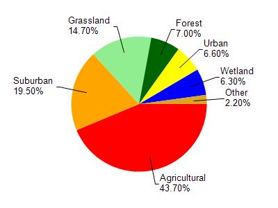
Baird Creek is located in the East River watershed which is 206.32 mi². Land use in the watershed is primarily agricultural (43.70%), suburban (19.50%) and a mix of grassland (14.70%) and other uses (22.10%). This watershed has 432.18 stream miles, 7,625.39 lake acres and 6,193.00 wetland acres.
Nonpoint Source Characteristics
This watershed is ranked High for runoff impacts on streams, Not Available for runoff impacts on lakes and High for runoff impacts on groundwater and therefore has an overall rank of High. This value can be used in ranking the watershed or individual waterbodies for grant funding under state and county programs.This water is ranked High Stream for individual Rivers based on runoff problems and the likelihood of success from project implementation.