Green Lake, Marquette
No
No
Yes
Fish and Aquatic Life
Overview
Puckaway Lake, in the Buffalo and Puckaway Lakes and Fox River - Berlin Watersheds, is a 5,013.45 acre lake that falls in Green Lake and Marquette Counties. This lake is managed for fishing and swimming and is currently considered impaired.
Date 2011
Author Aquatic Biologist
Historical Description
Source: 1971, Surface Water Resources of Green Lake County Lake Puckaway T-15-N, R-11, 12-E, Sections--Many Surface Acres = 5,433; S.D.F. = 2.09 Maximum Depth = 5 feet.
Lake Puckaway is a very shallow widening of the Fox River located in the southwestern part of the county. Silt, muck, and sand are major bottom materials. The Princeton Dam on the Fox River plays an important roll in regulating the levels of Lake Puckaway. In the past there has been much controversy concerning the maintenance of water levels at different times of the year. The lake must be lowered during the winter for flood control purposes and property owners claim this damages fishing and affects the operation of septic tanks. Because the lake is so shallow, there are large expanses of emergent vegetation, of which wild rice is a component. Large numbers of different species of ducks and geese use the lake for nesting and resting. Lake Puckaway is considered to be one of the best coot lakes in the state. Waterfowl hunting pressure is heavy and has resulted in a very high concentration of lead shot in the bottom sediments. The lakeprovides excellent winter and summer fishing, especially for northern pike and panfish. Northern pike, walleye, perch, largemouth bass, bluegill, black crappie, channel catfish, black bullhead, and carp are the most common fish present. White crappie, pumpkinseed, white bass, yellow bass, flathead catfish, white sucker, burbot, sheepshead, and rock sturgeon are also present. Four public access sites with boat ramps are located in the Village of Marquette. Other access sites are located two miles west of Marquette and on the north shore in Marquette County. Development is limited to the Village of Marquette on the south shore and numerous cottages on the north shore. In all, 137 dwellings and two resorts are present. Approximately 50 percent of the shoreline is in wild or semi-wild state.
Date 1971
Author Surface Water Inventory Of Wisconsin
General Condition
Puckaway Lake North Beach was assessed for the 2018 listing cycle; E. coli data sample data were clearly below the 2018 WisCALM listing thresholds for the Recreation use. This beach was meeting this designated use and was not considered impaired.
Date 2017
Author Ashley Beranek
Impaired Waters
Puckaway Lake (WBIC 158700) was placed on the impaired waters list for total phosphorus and sediment/total suspended solids in 2010. The 2018 assessments showed continued impairment by phosphorus; new total phosphorus and chlorophyll sample data exceeded the 2018 WisCALM listing thresholds for the Recreation use and Fish and Aquatic Life use. Based on the most updated information, no change in existing impaired waters listing was needed.
Date 2017
Author Ashley Beranek
Impaired Waters
Puckaway Lake (158700) was placed on the impaired waters list for total phosphorus and sediment/total suspended solids in 2010. The 2016 assessments showed continued impairment by phosphorus; total phosphorus sample data overwhelmingly exceed 2016 WisCALM listing thresholds for the Recreation use, exceeded Fish and Aquatic Life use, and chlorophyll data exceeded REC and FAL thresholds. Based on the most updated information, no change in existing impaired waters listing is needed.
Date 2015
Author Aaron Larson
Condition
Wisconsin has over 84,000 miles of streams, 15,000 lakes and milllions of acres of wetlands. Assessing the condition of this vast amount of water is challenging. The state's water monitoring program uses a media-based, cross-program approach to analyze water condition. An updated monitoring strategy (2015-2020) is now available. Compliance with Clean Water Act fishable, swimmable standards are located in the Executive Summary of Water Condition in 2018. See also the 'monitoring and projects' tab.
Reports
Recommendations
Lake Management Plan Implementation
Lk Puckaway P&R Dist proposes to conduct a Lake Management Plan Implementation project. Project deliverables include the following: 1) Employ plan implementation coordinator; 3 year term; 2) Public landing Kiosk Management at 3 Public landings, newsletter development, Fact sheet distribution, Lake plan implementation forums 2x/year, Bi-annual regional news releases on progress of plan implementation, Annual status reporting to assc partners & media; 3) Evaluate existing system of gauging stations while maintaining present monitoring schedule, including review for possible enhancements; rapid reporting & graphing, telemetric feasibility, number of stations/locations & estimate of costs; 4) Macro-Scale monitoring strategy will utilize summer aerial photography obtained from FFSA & 3 areas of the lake, Maiden Island, Bluebill Bay & Dead River, will be indexed using a Point-Intercept layout; 5) Radio-telemetry tagging of carp will be implemented; 6) Plot will be established to evaluate the rate of success between natural germination/expansion & artificially enhanced plant beds. Live plants will be planted & evaluated in a manner consistent with the micro-scale monitoring techniques; 7) Landing kiosks will include Lake Zone maps & channel marker buoys will be placed in the identified navigational lanes in the east basin; 8) USAOC & DNR Dam Safety Engineers to determine what modification will be permitted to the current structure, and/or what requirements need to be met; 9) Estimate nutrient & sediment loads from subwatershed areas draining the 805 sq mi watershed; 10) Demonstrate restorations & employ a 10 year natural shoreline restoration program with 10 demonstration sites will be developed & promoted; 11) Appraise existing tern habitat condition & complete tern management planning. Implement a variety of protection measures; 12) Methodology similar to DNR CHD methods will be employed.
Shoreland Monitoring, Assessment, Inventory
Green Lake County will conduct a land use and environmental resource inventory of the watershed surrounding Green Lake, Little Green Lake, and Lake Puckaway. The information from the study will be used to update the existing zoning and shoreland protection ordinances and to assess the need for a storm water management ordinance in the County, the stormwater management ordinance, if its need is determined, will be written
Management Goals
Wisconsin's Water Quality Standards provide qualitative and quantitative goals for waters that are protective of Fishable, Swimmable conditions [Learn more]. Waters that do not meet water quality standards are considered impaired and restoration actions are planned and carried out until the water is once again fishable and swimmable
Management goals can include creation or implementation of a Total Maximum Daily Load analysis, a Nine Key Element Plan, or other restoration work, education and outreach and more. If specific recommendations exist for this water, they will be displayed below online.
Monitoring
Monitoring the condition of a river, stream, or lake includes gathering physical, chemical, biological, and habitat data. Comprehensive studies often gather all these parameters in great detail, while lighter assessment events will involve sampling physical, chemical and biological data such as macroinvertebrates. Aquatic macroinvertebrates and fish communities integrate watershed or catchment condition, providing great insight into overall ecosystem health. Chemical and habitat parameters tell researchers more about human induced problems including contaminated runoff, point source dischargers, or habitat issues that foster or limit the potential of aquatic communities to thrive in a given area. Wisconsin's Water Monitoring Strategy was recenty updated.
Grants and Management Projects
Monitoring Projects
| WBIC | Official Waterbody Name | Station ID | Station Name | Earliest Fieldwork Date | Latest Fieldwork Date | View Station | View Data |
|---|
| 158700 | Puckaway Lake | 10040167 | Lake Puckaway - Huron Road Launch | | | Map | Data |
| 158700 | Puckaway Lake | 244004 | Puckaway Lake - Puckaway Lake | | | Map | Data |
| 158700 | Puckaway Lake | 10040168 | Lake Puckaway - Lotus Drive Launch | 5/26/2013 | 6/30/2020 | Map | Data |
| 158700 | Puckaway Lake | 243039 | Puckaway Lake - Deep Hole - West Basin Site 2 | 7/16/1996 | 4/22/2025 | Map | Data |
| 158700 | Puckaway Lake | 243038 | Puckaway Lake - Mouth At Lake Puckaway Fr1 Near Fox R At W End Site 1 | 5/10/1987 | 9/6/2023 | Map | Data |
| 158700 | Puckaway Lake | 10002717 | Puckaway Lake | 7/1/1984 | 6/30/2018 | Map | Data |
| 117900 | Fox River | 10002717 | Puckaway Lake | 7/1/1984 | 6/30/2018 | Map | Data |
| 158700 | Puckaway Lake | 10040164 | Lake Puckaway - W. Northshore Drive Launch | 7/20/2014 | 7/20/2014 | Map | Data |
| 158700 | Puckaway Lake | 243057 | Lake Puckaway - Lake Outlet To Fox R. | 6/2/2004 | 10/2/2004 | Map | Data |
| 158700 | Puckaway Lake | 243056 | Lake Puckaway - East Mid-Basin | 5/16/2004 | 9/6/2023 | Map | Data |
| 158700 | Puckaway Lake | 10019220 | Lake Puckaway - Elm Street Carry-in Access | 6/17/2011 | 6/30/2020 | Map | Data |
| 158700 | Puckaway Lake | 10019481 | Lake Puckaway - Sherman Avenue Launch | 8/17/2008 | 6/30/2020 | Map | Data |
| 158700 | Puckaway Lake | 10042007 | Puckaway Lake - north beach and landing | 6/3/2014 | 1/1/2015 | Map | Data |
| 158700 | Puckaway Lake | 10019221 | Lake Puckaway - Oak Road & Lake View Drive N. Launch | 8/22/2009 | 6/30/2020 | Map | Data |
| 158700 | Puckaway Lake | 072 | Fox River at Lake Puckaway | 7/24/2012 | 7/24/2012 | Map | Data |
| 158700 | Puckaway Lake | 10038609 | PUCKAWAY LAKE - FOX RIVER | 7/24/2012 | 7/24/2012 | Map | Data |
| 5027362 | Unnamed | 10040165 | Lake Puckaway - Arrowhead Road Launch | 6/2/2013 | 8/31/2013 | Map | Data |
| 158700 | Puckaway Lake | 243017 | Puckaway Lake - Deep Hole | 6/19/1991 | 6/19/1991 | Map | Data |
| 158700 | Puckaway Lake | 243063 | Lake Puckaway - Site 5 - North Of Marquette Fox River Channel | | | Map | Data |
| 158700 | Puckaway Lake | 10040163 | Lake Puckaway - Charlevoix Street Launch | 5/25/2013 | 6/30/2020 | Map | Data |
| 158700 | Puckaway Lake | 243062 | Lake Puckaway - Site 4 - West Of Drege Bank | | | Map | Data |
| 158700 | Puckaway Lake | 10019483 | Lake Puckaway - Lyons Street Launch | 6/17/2011 | 6/30/2020 | Map | Data |
| 158700 | Puckaway Lake | 243041 | Puckaway Lake - East Basin Site 5 | 8/14/2003 | 8/15/2004 | Map | Data |
| 158700 | Puckaway Lake | 10019482 | Lake Puckaway - Dodges Avenue Launch | 8/20/2008 | 6/30/2020 | Map | Data |
| 158700 | Puckaway Lake | 243040 | Puckaway Lake - Mid Basin Site 4 | 8/14/2003 | 10/2/2004 | Map | Data |
| 158700 | Puckaway Lake | 243061 | Lake Puckaway - Site 3 - North Of Millers Resort | | | Map | Data |
| 158700 | Puckaway Lake | 10040166 | Lake Puckaway - Apuckawa Park Access | 5/26/2013 | 10/4/2020 | Map | Data |
|
Watershed Characteristics
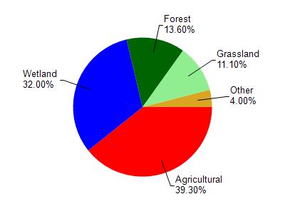
Puckaway Lake is located in the Fox River - Berlin watershed which is 208.74 mi². Land use in the watershed is primarily agricultural (39.30%), wetland (32%) and a mix of forest (13.60%) and other uses (15.10%). This watershed has 328.14 stream miles, 453.54 lake acres and 41,067.20 wetland acres.
Nonpoint Source Characteristics
This watershed is ranked Medium for runoff impacts on streams, Not Available for runoff impacts on lakes and High for runoff impacts on groundwater and therefore has an overall rank of High. This value can be used in ranking the watershed or individual waterbodies for grant funding under state and county programs.However, all waters are affected by diffuse pollutant sources regardless of initial water quality. Applications for specific runoff projects under state or county grant programs may be pursued. For more information, go to surface water program grants.