La Crosse
No
No
Yes
Fish and Aquatic Life
Overview
All of the Little La Crosse River Watershed ultimately drains to Lake Neshonoc via the La Crosse River. High bacterial counts, nuisance algal blooms, and sedimentation of the lake are all due to the runoff of soil, nutrients, and bacteria from the land in this watershed and the Upper La Crosse River Watershed above Perch Lake. The La Crosse County Health Department has closed the Lake Neshonoc swimming beaches on a regular basis due to harmful bacteria levels. Additionally, sediment is currently being dredged from Lake Neshonoc at great expense. See additional discussion of Lake Neshonoc on page 102 of this report.
Date 2011
Author Aquatic Biologist
Historical Description
Source: 1971, Surface Water Resources of LaCrosse County Neshonoc Lake, T17N, R6W, S26, 27, 34, 35, 36 Surface Acres = 6.87.2, S.D.F.-3.20, Maximum Depth = 11 feet.
This drainage impoundment is located on the LaCrosse River and has medium hard, alkaline water. At the time of investigation, the water was turbid and had a low transparency. The dam has a height of 14 feet and has been acquired by the county from the Northern States Power Company. Northern pike, largemouth bass, channel catfish, bluegill, black crappie, white crappie, pumpkinseed, and bullhead are the primary sport fish species, with bluegill and crappie dominating. Carp are abundant and a problem. The turbidity of the lake is mainly due to this species. An attempt was made to reduce the carp population in 1962 through drawdown and mechanical carp removal by commercial fishermen. Any benefits that may have resulted from that operation proved temporary. Pollutants, including silt, fertilizer, and sewage materials enter the impoundment. The public swimming area has been closed on occasion by public health officials because of dangerously high cloriform counts. Developments include 16 dwellings, one resort, one private campground, and a public park. The latter is a multiple use area that includes a boat launch with parking, picnic area, and a public swimming area. Access is possible from the park and other county-owned land, and from the LaCrosse River. Beaver are present and muskrat are significant. Broods of mallards, teal, and wood ducks may be seen on the lake and puddle and diving ducks, coot, and Canada geese use the flowage during migrations.
Date 1971
Author Aquatic Biologist
Impaired Waters
Neshonoc Lake (1653500) was placed on the impaired waters list in 1998 for Mercury, sediment/total suspended solids, and total phosphorus. The 2018 assessments showed continued impairment by phosphorus; new total phosphorus sample data exceeded 2018 WisCALM listing thresholds for the Recreation use and Fish and Aquatic Life use. Chlorophyll data only exceeded REC thresholds, but no criteria was available for the FAL use threshold. Based on the most updated information, the impairment of excess algal growth was added.
Date 2017
Author Ashley Beranek
Impaired Waters
Neshonoc Lake (1653500) was placed on the impaired waters list in 1998 for Mercury, sediment/total suspended solids, and total phosphorus. The 2016 assessments showed continued impairment by phosphorus; total phosphorus sample data exceed 2016 WisCALM listing thresholds for the Recreation use and Fish and Aquatic Life use. Based on the most updated information, no change in existing impaired waters listing is needed.
Date 2015
Author Aaron Larson
Condition
Wisconsin has over 84,000 miles of streams, 15,000 lakes and milllions of acres of wetlands. Assessing the condition of this vast amount of water is challenging. The state's water monitoring program uses a media-based, cross-program approach to analyze water condition. An updated monitoring strategy (2015-2020) is now available. Compliance with Clean Water Act fishable, swimmable standards are located in the Executive Summary of Water Condition in 2018. See also the 'monitoring and projects' tab.
Reports
Recommendations
Monitor or Propose 303(d) Listing
La Crosse proposes to monitor one lake (impoundment) in 2012 that is currently on the 303d list. Data collection will include collecting Total Phosphorus (TP) and Chlorophyll a (Chl a) samples and documenting the vertical dissolved oxygen and temperature profiles. The monitoring activites are proposed for Lake Neshonoc located in La Crosse County.
Management Goals
Wisconsin's Water Quality Standards provide qualitative and quantitative goals for waters that are protective of Fishable, Swimmable conditions [Learn more]. Waters that do not meet water quality standards are considered impaired and restoration actions are planned and carried out until the water is once again fishable and swimmable
Management goals can include creation or implementation of a Total Maximum Daily Load analysis, a Nine Key Element Plan, or other restoration work, education and outreach and more. If specific recommendations exist for this water, they will be displayed below online.
Monitoring
Monitoring the condition of a river, stream, or lake includes gathering physical, chemical, biological, and habitat data. Comprehensive studies often gather all these parameters in great detail, while lighter assessment events will involve sampling physical, chemical and biological data such as macroinvertebrates. Aquatic macroinvertebrates and fish communities integrate watershed or catchment condition, providing great insight into overall ecosystem health. Chemical and habitat parameters tell researchers more about human induced problems including contaminated runoff, point source dischargers, or habitat issues that foster or limit the potential of aquatic communities to thrive in a given area. Wisconsin's Water Monitoring Strategy was recenty updated.
Grants and Management Projects
Monitoring Projects
| WBIC | Official Waterbody Name | Station ID | Station Name | Earliest Fieldwork Date | Latest Fieldwork Date | View Station | View Data |
|---|
| 1653500 | Neshonoc Lake | 10030929 | Neshonoc Lake -- Swarthout Park Boat Ramp | 8/10/2011 | 8/16/2025 | Map | Data |
| 1653500 | Neshonoc Lake | 323122 | Neshonoc Lake - Deep Hole | 7/24/1973 | 6/16/2022 | Map | Data |
| 1653500 | Neshonoc Lake | 10003118 | Neshonoc Lake | 4/23/1994 | 6/17/2022 | Map | Data |
| 1653500 | Neshonoc Lake | 10017758 | Neshonoc Lake -- Access | 8/30/2003 | 7/31/2022 | Map | Data |
| 1653500 | Neshonoc Lake | 322132 | Neshonoc Lake - Highway 16 Bridge-150 Yds Above | 7/19/1994 | 7/19/1994 | Map | Data |
| 1653500 | Neshonoc Lake | 10060087 | Neshonoc Lake at Lake Rd | | | Map | Data |
|
Watershed Characteristics
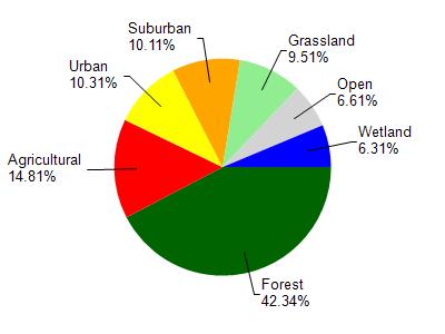
Neshonoc Lake is located in the Lower La Crosse River watershed which is 145.46 mi². Land use in the watershed is primarily forest (42.30%), agricultural (14.80%) and a mix of urban (10.30%) and other uses (32.50%). This watershed has 295.20 stream miles, 1,187.12 lake acres and 5,641.64 wetland acres.
Nonpoint Source Characteristics
This watershed is ranked Medium for runoff impacts on streams, Not Ranked for runoff impacts on lakes and Low for runoff impacts on groundwater and therefore has an overall rank of Low. This value can be used in ranking the watershed or individual waterbodies for grant funding under state and county programs.This water is ranked High Lake for individual Impoundments based on runoff problems and the likelihood of success from project implementation.