Polk
No
No
No
Fish and Aquatic Life
Overview
Church Pine Lake (Pine), in the Lower Apple River Watershed, is a 87.08 acre lake that falls in Polk County. This lake is managed for fishing and swimming and is currently not considered impaired.
Date 2011
Author Aquatic Biologist
Historical Description
These lakes' communities formed a lake management district approximately a decade ago. They
have financed an independent feasibility study which was completed by "Lim Tech Consultants"
in Oct., 1987. These connected lakes are somewhat unique in that the water quality in
Churchpine is markedly higher than that of Big Lake and to a degree Round Lake. Some of
this difference can be attributed to basin morphometry but it appears that watershed sources
may be impacting the nutrient budget of Big Lake.
A self-help volunteer has been monitoring conditions on these lakes since 1985. It is
recommended that this lake district receive high priority for planning grants or other study
funding to document watershed conditions and plan for possible non-point source remedial
activities.
Date 1992
Author Surface Water Inventory Of Wisconsin
Historical Description
Source: 1961, Surface Water Resources of Polk County Church Pine Lake (Pine Lake) T32N, R18W, Sec. 1, 12 Surface Acres = 88.0, S.D.F. = 1.78, Maximum Depth = 45 ft., M.P.A. = 76 This lake has a navigable channel to Wind Lake. Fish species present include northern pike, walleyes, largemouth bass, bluegills, black crappies, rock bass, pumpkinseed and bullheads. There is a private access on the south end of the lake used at no charge by public. No parking area except on town road. Private developments include 11 cottages. Six acres of marsh wetlands serve as a nesting area for mallards.
Date 1961
Author Surface Water Inventory Of Wisconsin
General Condition
Church Pine Lake (Pine) (2616100) was assessed during the 2016 listing cycle; chlorophyll sample data were clearly below 2016 WisCALM listing thresholds for the Recreation use and Fish and Aquatic Life use. This water was also assessed for chlorides and sample data were clearly below 2016 WisCALM chronic and acute listing criteria for the Fish and Aquatic Life use. This water is meeting these designated uses and is not considered impaired.
Date 2015
Author Ashley Beranek
Condition
Wisconsin has over 84,000 miles of streams, 15,000 lakes and milllions of acres of wetlands. Assessing the condition of this vast amount of water is challenging. The state's water monitoring program uses a media-based, cross-program approach to analyze water condition. An updated monitoring strategy (2015-2020) is now available. Compliance with Clean Water Act fishable, swimmable standards are located in the Executive Summary of Water Condition in 2018. See also the 'monitoring and projects' tab.
Reports
Recommendations
Best Management Practices, Implement
Partnering with property owners, the applicant is sponsoring a grant to implement water quality and habitat best practices from Wisconsin's Healthy Lakes Implementation Plan. Best practices, including fish sticks, 350 sq. ft. native plantings, diversions, rock infiltration, and/or rain gardens, will be designed and installed according to the Healthy Lakes fact sheets, technical guidance and grant application.
Habitat Restoration - Shoreland
The following practices are dispersed along all three lakes: fish sticks on 1 and 350 ft2 native plantings on 8 lakeshore properties.
Aquatic Plant Management Plan
The Church Pine, Round and Big Lake Protection and Rehabilitation District proposes to conduct a macrophyte survey on Church Pine and Round Lakes to evaluate the functions and values of the current macrophyte communities.
Management Goals
Wisconsin's Water Quality Standards provide qualitative and quantitative goals for waters that are protective of Fishable, Swimmable conditions [Learn more]. Waters that do not meet water quality standards are considered impaired and restoration actions are planned and carried out until the water is once again fishable and swimmable
Management goals can include creation or implementation of a Total Maximum Daily Load analysis, a Nine Key Element Plan, or other restoration work, education and outreach and more. If specific recommendations exist for this water, they will be displayed below online.
Monitoring
Monitoring the condition of a river, stream, or lake includes gathering physical, chemical, biological, and habitat data. Comprehensive studies often gather all these parameters in great detail, while lighter assessment events will involve sampling physical, chemical and biological data such as macroinvertebrates. Aquatic macroinvertebrates and fish communities integrate watershed or catchment condition, providing great insight into overall ecosystem health. Chemical and habitat parameters tell researchers more about human induced problems including contaminated runoff, point source dischargers, or habitat issues that foster or limit the potential of aquatic communities to thrive in a given area. Wisconsin's Water Monitoring Strategy was recenty updated.
Grants and Management Projects
| Project Name (Click for Details) | Year Started |
|---|
| POLK COUNTY LWRD: Church Pine, Round, & Big Lakes Water Quality & Biological Assessment | 2012 |
| CHURCH PINE ROUND & BIG LAKE P & R DISTRICT: Church Pine, Round, Big Lake Protection and Rehabilitation District 2016 Clean Boats Clean Waters | 2016 |
| CHURCH PINE ROUND & BIG LAKE P & R DISTRICT: HLk-Church Pine, Round, & Big Lakes Healthy Lakes Project | 2015 |
| CHURCH PINE ROUND & BIG LAKE P & R DISTRICT: HLK-Church Pine, Round & Big Healthy Lakes 2017 | 2017 |
| CHURCH PINE ROUND & BIG LAKE P & R DISTRICT: CHURCH PINE ROUND & BIG LAKE P & R DISTRICT 2024 CBCW | 2024 |
| POLK COUNTY: Shoreline Protection in the Horse Lake-Horse Creek Watershed | 2025 |
| CHURCH PINE ROUND & BIG LAKE P & R DISTRICT: Big, Round, Church Pine Aquatic Plant Management Plan | 2009 |
| CHURCH PINE ROUND & BIG LAKE P & R DISTRICT: APM Plan Implementation | 2011 |
| CHURCH PINE ROUND & BIG LAKE P & R DISTRICT: Church Pine Round & Big Lake P & R District 2021 CBCW | 2021 |
| CHURCH PINE ROUND & BIG LAKE P & R DISTRICT: Church Pine Round & Big Lake P & R District 2023 CBCW | 2023 |
| CHURCH PINE ROUND & BIG LAKE P & R DISTRICT: Church Pine and Round Lakes Macrophyte Survey | 1997 |
| CHURCH PINE ROUND & BIG LAKE P & R DISTRICT: Church Pine, Round, Big Lake Clean Boats Clean Waters Project 2014 | 2014 |
| CHURCH PINE ROUND & BIG LAKE P & R DISTRICT: Church Pine Round & Big Lake P&R District 2017 CBCW | 2017 |
| CHURCH PINE ROUND & BIG LAKE P & R DISTRICT: Church Pine, Round and Big Lake Clean Boats Clean Waters Project 2015 | 2015 |
| CHURCH PINE ROUND & BIG LAKE P & R DISTRICT: Big and Church Pine Aquatic Plant Surveys | 2009 |
| CHURCH PINE ROUND & BIG LAKE P & R DISTRICT: Big, Round and Church Pine PI Survey and APM Plan Update | 2020 |
| CHURCH PINE ROUND & BIG LAKE P & R DISTRICT: Big, Round and Church Pine PI Survey and APM Plan Update | 2020 |
| CHURCH PINE ROUND & BIG LAKE P & R DISTRICT: APM Plan Implementation | 2013 |
| CHURCH PINE ROUND & BIG LAKE P & R DISTRICT: Church Pine Round & Big Lake P & R District 2022 CBCW | 2022 |
| Fish Propagation Actions | 2001 |
| CHURCH PINE ROUND & BIG LAKE P & R DISTRICT: Church Pine, Round, & Big Lake AIS Education, Prevention & Planning | 2009 |
| CHURCH PINE ROUND & BIG LAKE P & R DISTRICT: Church Pine Round & Big Lake P & R District 2025 CBCW | 2025 |
|
Monitoring Projects
| WBIC | Official Waterbody Name | Station ID | Station Name | Earliest Fieldwork Date | Latest Fieldwork Date | View Station | View Data |
|---|
| 2616100 | Church Pine Lake | 493108 | Church Pine Lake - Deep Hole | 4/16/1986 | 9/1/2025 | Map | Data |
| 2616100 | Church Pine Lake | 10004978 | Church Pine Lake | 8/7/2001 | 5/25/2025 | Map | Data |
| 2616100 | Church Pine Lake | 10018328 | Church Pine Lake -- Access at 45th Ave | 7/22/2003 | 5/31/2026 | Map | Data |
|
Watershed Characteristics
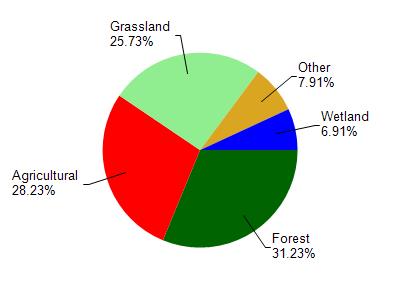
Church Pine Lake is located in the Lower Apple River watershed which is 202.16 mi². Land use in the watershed is primarily forest (31.20%), agricultural (28.20%) and a mix of grassland (25.70%) and other uses (14.80%). This watershed has 151.64 stream miles, 4,391.99 lake acres and 9,095.80 wetland acres.
Nonpoint Source Characteristics
This watershed is ranked High for runoff impacts on streams, Medium for runoff impacts on lakes and High for runoff impacts on groundwater and therefore has an overall rank of High. This value can be used in ranking the watershed or individual waterbodies for grant funding under state and county programs.This water is ranked High Stream for individual Lakes based on runoff problems and the likelihood of success from project implementation.