Kenosha
No
No
No
Fish and Aquatic Life
Overview
Lake Marie is located immediately above Lake Elizabeth to which it drains and is the 5th largest lake in the country. Virtually all of its shoreline is developed with 170 cottages and other developments. There is no pristine wild frontage except on a channel on the west side and much of this is being encroached upon by developments. There is little habitat for waterfowl except on the lake itself where feeding and resting areas are available during spring and fall migratory flights. Upland game is restricted to areas of the watershed relatively far from the lake and consists of pheasants, squirrels, cottontail rabbits, fox, and deer. Marsh furbearers such as muskrats, raccoons, and mink are present along the immediate lakeshore and channels. The warm water fishery includes walleyes, northern pike, and largemouth bass. Walleyes (marked by fin-clipping) were stocked in alternate years until the public launching site at Lance Park. Survey information up to that time indicated that there was no natural reproduction and that periodic fingerling stocking is necessary to maintain the walleye population. Panfish species common to the fishery include bluegills, crappies, sunfish, and perch. The most recent survey indicated that the bluegills were slow-growing. Other fish species include carp, suckers, garfish, chub suckers, bowfin, and golden shiner. Urban runoff is a probable source into the lake. There are several platted access points along its shoreline, but the only developed public access is in a village park on the north side of the lake where the fees were considered unreasonable by DNR standards. These fees have since been reduced to the maximum allowed by DNR code.
Source: 1982, Surface Water Resources of Kenosha County Lake Mary (Marie Lake), TIN, R19E, Section 21, 28 Surface Acres = 315, Maximum Depth = 33 ft, Secchi disc = 3.0 ft
Date 1982
Author Aquatic Biologist
General Condition
Lake Mary (Marie Lake) (743000) was assessed during the 2016 listing cycle; total phosphorus and chlorophyll sample data were clearly below 2016 WisCALM listing thresholds for the Recreation use and Fish and Aquatic Life use. This water is meeting these designated uses and is not considered impaired.
Date 2015
Author Ashley Beranek
Condition
Wisconsin has over 84,000 miles of streams, 15,000 lakes and milllions of acres of wetlands. Assessing the condition of this vast amount of water is challenging. The state's water monitoring program uses a media-based, cross-program approach to analyze water condition. An updated monitoring strategy (2015-2020) is now available. Compliance with Clean Water Act fishable, swimmable standards are located in the Executive Summary of Water Condition in 2018. See also the 'monitoring and projects' tab.
Reports
Management Goals
Wisconsin's Water Quality Standards provide qualitative and quantitative goals for waters that are protective of Fishable, Swimmable conditions [Learn more]. Waters that do not meet water quality standards are considered impaired and restoration actions are planned and carried out until the water is once again fishable and swimmable
Management goals can include creation or implementation of a Total Maximum Daily Load analysis, a Nine Key Element Plan, or other restoration work, education and outreach and more. If specific recommendations exist for this water, they will be displayed below online.
Monitoring
Monitoring the condition of a river, stream, or lake includes gathering physical, chemical, biological, and habitat data. Comprehensive studies often gather all these parameters in great detail, while lighter assessment events will involve sampling physical, chemical and biological data such as macroinvertebrates. Aquatic macroinvertebrates and fish communities integrate watershed or catchment condition, providing great insight into overall ecosystem health. Chemical and habitat parameters tell researchers more about human induced problems including contaminated runoff, point source dischargers, or habitat issues that foster or limit the potential of aquatic communities to thrive in a given area. Wisconsin's Water Monitoring Strategy was recenty updated.
Grants and Management Projects
Monitoring Projects
| WBIC | Official Waterbody Name | Station ID | Station Name | Earliest Fieldwork Date | Latest Fieldwork Date | View Station | View Data |
|---|
| 743000 | Lake Mary | 10003093 | Lake Mary | 6/1/1993 | 8/2/2024 | Map | Data |
| 743000 | Lake Mary | 303121 | Lake Mary - Deep Hole | 9/17/1973 | 4/22/2026 | Map | Data |
| 743000 | Lake Mary | 10014817 | Lake Mary (Marie) | | | Map | Data |
| 743000 | Lake Mary | 10017566 | Mary Lake -- Access Nr Lance Dr Twin Lks | 7/3/2004 | 8/2/2024 | Map | Data |
|
Watershed Characteristics
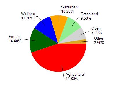
Lake Mary is located in the White River and Nippersink Creek watershed which is 168.35 mi². Land use in the watershed is primarily agricultural (44.80%), forest (14.40%) and a mix of wetland (11.30%) and other uses (29.50%). This watershed has 239.00 stream miles, 8,603.24 lake acres and 10,838.84 wetland acres.
Nonpoint Source Characteristics
This watershed is ranked High for runoff impacts on streams, Medium for runoff impacts on lakes and High for runoff impacts on groundwater and therefore has an overall rank of High. This value can be used in ranking the watershed or individual waterbodies for grant funding under state and county programs.This water is ranked High Lake for individual Lakes based on runoff problems and the likelihood of success from project implementation.