Green
No
No
Yes
Fish and Aquatic Life
Overview
Originating just north of Monroe, Honey Creek is a 16-mile long stream that flows southwest to Illinois where it enters the Pecatonica River. The stream has a drainage area of 33 square miles. Hawthorne Creek, Spring Creek, Whitehead Creek and four unnamed tributaries contribute flow to Honey Creek before it leaves Green County.
The upper portion of the stream flows through a city park and a residential area of Monroe, with the remainder running through woods, cropland and pasture. Scarce bank cover has led to moderate bank erosion, yet the water is usually clear. Muck and silt are the primary bottom types, although gravel, sand, rubble and hardpan can be found in places. Effluent from the Monroe Sewage Disposal Plant enters the stream below Monroe and in the past has adversely affected the downstream aquatic life. Measures have been taken to improve this situation.
In 1998, it was placed on the state 303(d) list of impaired waters due to habitat degradation caused by excessive sedimentation. The listing was divided into two segments, from the headwaters downstream to the junction with Hawthorne Creek, and then from Hawthorne Creek downstream to the state line. The upstream portion of the stream is affected by inputs from agriculture as well as urban runoff from Monroe and effluent discharges. The lower portion is mostly affected by agricultural runoff.
Date 2008
Author James Amrhein
Historical Description
Honey Creek flows southwest into Illinois and is managed for forage fish and suckers. Carp, redhorse, and common white sucker are present in significant numbers. There have been reports of trout caught in this stream. smallmouth bass are present in the lower section of the stream. Approximately 56 acres of wetland adjoin the stream.Very little bank cover is present, and raw earth banks are common.
Surface Acres= 24.4, Miles= 20.0, Gradient= 12.0' per mile. From: Poff, Ronald J., and C.W. Threinen, Lake and Stream Classification Project. Surface Water Resources of Green County, Wisconsin Conservation Department, Madison I, 1961.
Date 1961
Author Surface Water Inventory Of Wisconsin
Land Use
Monroe lies in the Honey and Richland Creeks Watershed in south central Green County. The named streams that will likely be impacted by growth in Monroe and the extended sewer service area lie to the south and west of the city. These include Honey Creek, Hawthorne Creek, and Little Richland Creek. The Monroe wastewater treatment plant 'discharges to Honey Creek. Little Richland Credc eventually joins Richland Creek, which is an Exceptional Resource Water.
There are several small, scattered steep slope areas (> 12%) along the perimeter of the sewer service area. There are also scattered wetland areas along each of the stream corridors. These areas should be identified as environmentally sensitive areas and protected from development.
Many of the streams in the watershed suffer from the effects of non-point source pollution, caused primarily by agricultural runoff. Approximately 80 percent of the watershed is in agriculture with a number of dairy operations. Excessive stream bank pasturing lends itself to habitat degradation by causing sedimentation, which covers hard substrate, and trampled down banks which make the stream wider and shallower. Runoff of manure adds nutrients which lead to algal and macrophyte growth.
However, growth of the city and the expansion of impervious surfaces, particularly in the headwater streams, could affect baseflow as well as peak flows of these streams. Such development could exacerbate the non-point source problems in the region.
Date 2003
Author City Of Monroe - Dpw
Facilities Management
The wastewater treatment plant discharges to the stream. Honey Creek is classified as a warm water sport fishery and contains bass and channel catfish. Monitoring was conducted in 1996 in response to a fish kill caused by a release of ammonia from the Monroe sewerage treatment plant. Northern pike were subsequently re-stocked in the creek. Urban nonpoint sources of pollution, including increased runoff from urban impervious surfaces such as pavement add to sedimentation problems in the creek. The city of Monroe is currently working on a sewer service area plan to protect water resources from potential problems associated with growth and development.
In addition to the Monroe Sewerage Treatment Plant, several industries discharge small amounts of non-contact cooling water to the creek. The stream had fish kills in the past. Improvements to the plant in the 1980?s vastly improved the operation of the plant. However, the treatment plant does add nutrients to the system which encourages plant and algal growth.
Date 2008
Author James Amrhein
General Condition
In 1998, the stream was placed on the state 303(d) list of impaired waters due to habitat degradation caused by excessive sedimentation. The listing was divided into two segments, from the headwaters downstream to the junction with Hawthorne Creek, and then from Hawthorne Creek downstream to the state line. The upstream portion of the stream is affected by inputs from agriculture as well as urban runoff from Monroe and effluent discharges. The lower portion is mostly affected by agricultural runoff.
Date 2008
Author James Amrhein
Condition
Wisconsin has over 84,000 miles of streams, 15,000 lakes and milllions of acres of wetlands. Assessing the condition of this vast amount of water is challenging. The state's water monitoring program uses a media-based, cross-program approach to analyze water condition. An updated monitoring strategy (2015-2020) is now available. Compliance with Clean Water Act fishable, swimmable standards are located in the Executive Summary of Water Condition in 2018. See also the 'monitoring and projects' tab.
Reports
Recommendations
Monitor or Propose 303(d) Listing
Monitor Honey Creek for habitat impairment caused by sedimentation. Conduct fisheries IBI and habitat assessment Honey Creek (3 sites) and one site on each of 3 major tributaries. Conduct monthly nutrient analysis (12) of Honey Creek below WWTP outfall. Conduct watershed assessment to determine sediment sources. Conduct macroinvertebrate analysis at 6 sites.
TMDL Monitoring
Monitor Honey Creek (892300) for habitat impairment caused by sedimentation. Conduct fisheries IBI and habitat assessment Honey Creek (3 sites) and one site on each of 3 major tributaries. Conduct monthly nutrient analysis (12) of Honey Creek below WWTP outfall. Conduct watershed assessment to determine sediment sources. Conduct macroinvertebrate analysis at 6 sites.
Monitor Watershed (Status,Sources,Impairments)
Watershed Planning Update
Sewer Service Area Planning
This Sanitary Sewer Service Area Plan is intended to complement previous planning efforts and provide a framework for guiding future development in the area in order to protect the water quality of the watershed. The Plan takes into account the technical, environmental and growth projections of the City in establishing the sewer service area.
Management Goals
Wisconsin's Water Quality Standards provide qualitative and quantitative goals for waters that are protective of Fishable, Swimmable conditions [Learn more]. Waters that do not meet water quality standards are considered impaired and restoration actions are planned and carried out until the water is once again fishable and swimmable
Management goals can include creation or implementation of a Total Maximum Daily Load analysis, a Nine Key Element Plan, or other restoration work, education and outreach and more. If specific recommendations exist for this water, they will be displayed below online.
Monitoring
Monitoring the condition of a river, stream, or lake includes gathering physical, chemical, biological, and habitat data. Comprehensive studies often gather all these parameters in great detail, while lighter assessment events will involve sampling physical, chemical and biological data such as macroinvertebrates. Aquatic macroinvertebrates and fish communities integrate watershed or catchment condition, providing great insight into overall ecosystem health. Chemical and habitat parameters tell researchers more about human induced problems including contaminated runoff, point source dischargers, or habitat issues that foster or limit the potential of aquatic communities to thrive in a given area. Wisconsin's Water Monitoring Strategy was recenty updated.
Grants and Management Projects
Monitoring Projects
| WBIC | Official Waterbody Name | Station ID | Station Name | Earliest Fieldwork Date | Latest Fieldwork Date | View Station | View Data |
|---|
| 892300 | Honey Creek | 233082 | Honey Creek at Tn Rd Rmi 2.1 | | | Map | Data |
| 892300 | Honey Creek | 10014475 | Honey Creek-50m Upstream Of Cth P Bridge | 11/1/2006 | 9/30/2015 | Map | Data |
| 892300 | Honey Creek | 10013083 | Honey Creek Upstream Of Allen Rd. | 1/1/2015 | 1/1/2015 | Map | Data |
| 892300 | Honey Creek | 10032531 | Honey Creek below confluence w/ un. intermittent trib. Clarno | | | Map | Data |
| 892300 | Honey Creek | 10014476 | Honey Creek-Upstream Of Honey Creek Rd | 11/1/2006 | 11/1/2006 | Map | Data |
| 892300 | Honey Creek | 10009518 | Honey Creek At Cty Hk Bridge | 11/15/2002 | 7/21/2015 | Map | Data |
| 892300 | Honey Creek | 10014490 | Honey Creek-330 M Us Cth P At Woodline | | | Map | Data |
| 892300 | Honey Creek | 10031710 | Honey Creek at Hudson Road | | | Map | Data |
| 892300 | Honey Creek | 10032530 | Honey Creek below confluence w/ Hawthorne Creek | | | Map | Data |
|
Watershed Characteristics
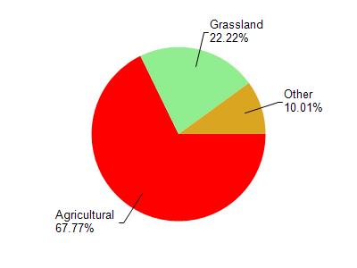
Honey Creek is located in the Honey and Richland Creeks watershed which is 80.09 mi². Land use in the watershed is primarily agricultural (67.70%), grassland (22.20%) and a mix of suburban (4.40%) and other uses (5.60%). This watershed has 195.33 stream miles, 16.47 lake acres and 117.89 wetland acres.
Nonpoint Source Characteristics
This watershed is ranked Medium for runoff impacts on streams, Not Ranked for runoff impacts on lakes and High for runoff impacts on groundwater and therefore has an overall rank of High. This value can be used in ranking the watershed or individual waterbodies for grant funding under state and county programs.However, all waters are affected by diffuse pollutant sources regardless of initial water quality. Applications for specific runoff projects under state or county grant programs may be pursued. For more information, go to surface water program grants.