Iowa
Yes
No
Yes
Fish and Aquatic Life
Overview
Brewery Creek is a 5 mile long stream located in southern Iowa County. It originates northeast of the Village of Mineral Point and flows southward to join Rock Branch. The combined flows are then called Furnace Branch which flows another 5 miles toward the southwest to join the Mineral Point Branch. Lead and zinc mining was prevalent in southwestern Wisconsin in the late 1800’s and early 1900’s. Mining waste severely polluted Brewery Creek. The few fish and macroinvertebrate species that were found were considered “tolerant” to pollution (Schlesser, 1990). The stream was considered “biologically dead” due to toxic metals and the smothering effect of ferric hydroxide precipitate (Marshall and Fix, 1995).
In 1992-1993, a major rehabilitation project took place which involved moving four roaster pile to a central containment area and re-routing the stream away from this “disposal” site. Metals concentrations in the water column decreased by 80% and the stream no longer was rust colored (Ibid). While the stream responded favorably to this action, most of the fauna was still dominated by a few tolerant species. In 1998, the department listed Brewery Creek on its list of impaired, 303(d) waters. In 1998 and 1999, water samples from Brewery Creek were tested in laboratory biomonitoring assays using the cladaceran Ceriodaphnia dubia and fathead minnow (Pimephales promelas). Tests showed chronic toxicity in C. dubia (mean number of young significantly reduced) while other acute and chronic tests showed no significant difference between the test water and the control.
Date 2010
Author James Amrhein
Overview
Brewery Creek rises near Mineral Point and flows south to the junction with Rock Branch, where it becomes Furnace Creek. Runoff from roaster piles has severely degraded water quality and in-stream habitat, demonstrated by the limited aquatic life biological use classification of the stream (Schlesser, 1988). A 1990 report documented low fish populations and poor fish diversity in the reach below the roaster pile (Schlesser, 1990). Additional monitoring in the summer of 1992 confirmed this (Marshall, 1992-93).
An Environmental Repair Fund (ERF) project to consolidate and cap the roaster piles began in early 1992, and was completed in the fall of 1993, with the purpose of improving water quality and in-stream habitat. A portion of the highly degraded streambed near the consolidated roaster pile was filled, with a new stream channel dug and the stream diverted to it. Brook trout were planted in the new stream channel in the fall of 1993. Wetlands immediately adjacent the consolidated roaster pile have also been degraded by runoff from the pile. We expect that water quality and in-stream habitat will improve significantly once the ERF project is completed, perhaps allowing the stream to be reclassified as at least supporting forage fishery. Southern District Water Resources Management staff monitored the stream in 1994 to assess conditions, including surface water quality, in-stream habitat, fisheries, stream bottom sediment and wetlands to determine success of the ERF project.
In the spring of 1994, brook trout were still present in Brewery Creek, along with a variety of forage fish. Water quality chemistry parameters had improved although the levels for zinc are still considered high. Levels of heavy metals in stream sediment vary. Ins-tream habitat is poor in some reaches. Southern District staff will continue to monitor the creek in 1995. A formal stream classification for Brewery Creek will be done once the stream has stabilized.
Date 2002
Author Steve Fix
Overview
Brewery Creek rises near Mineral Point and flows south to its junction with Rock Branch, forming Furnace Creek. The Mineral Point waste water treatment plant discharges to this stream. Runoff from roaster piles has severely degraded water quality and in-stream habitat. An Environmental Repair Fund (ERF) project to consolidate and cap the roaster piles began in early 1992 and was completed in 1993, with the purpose of improving water quality and instream habitat. A portion of the highly degraded streambed near the consolidated roaster pile was filled, with a new stream channel dug and the stream diverted to it. Brook trout were planted in the new stream channel in fall of 1993 (1995 basin plan).
The stream was monitored in spring 1994. Brook trout were still present along with a variety of forage fish. Water chemistry had improved although levels of zinc were still considered high. Subsequent sampling in 1995 and 1996, along with a full baseline survey conducted in 2000 show that despite the stream’s improvement over its original condition, it still contains high levels of metals that limit aquatic life (Simms). It was thought at one time the stream could potentially support a warm water forage fishery, but impacts from the historic mining and runoff from the city of Mineral Point are going to limit the use to a limited forage fishery (Marshall). The stream is no longer stocked with trout.
Date 2002
Author James Amrhein
Historical Description
Brewery Creek -Mouth location T4N R3E Section 18 -13, Surface area = 2.8 acres, Length = 5.0 miles, Gradient = 46.0 feet per mile, Total alkalinity = 257.0 mg/l, Volume of flow = 2.5 cfs.
The name of this stream originated because a small, now defunct, local brewery was located near its headwaters.
Its water temperatures are fairly stable throughout the year since seepage springs are one of its principal sources of water. However, its waters run through the city of Mineral Point wherein "poor quality effluent is known to enter the stream. A zinc and lead ore concentration plant settling pond and milk processing establishments are sources. The high quantities of electrolyte produce a high conductivity reading. The heavy orange precipitate found on the stream bottom and in its waters is especially evident after it passes through the city. A seining survey revealed that very little or no fish life is present in this stream, which is undoubtedly a result of such harsh environmental conditions. Wildlife use of the stream for habitat and food is also restricted for this reason.
It flows in a southerly direction until it meets the Rock Branch where the combined waters are called the Furnace Creek. Over 90 percent of its watershed area is devoted to agriculture and about six percent to woodlands. A single tributary enters Brewery Creek near the city and contributes about one-third of its baseflow. The tributary possesses water of good quality. Nevertheless, these waters do not seem to chanpe the status of mainstream waters to any great extent. There is no public land along this water but it can be reached from two city streets.
From: Piening, Ronald and Threinen, C.W., Lake and Stream Classification Project. Surface Water Resources of Iowa County, Department of Natural Resources, 1968.
Date 1968
Author Surface Water Inventory Of Wisconsin
Impaired Waters
The 2018 assessments of Brewery Creek (Rock Branch to Copper Street in Mineral Point) showed biological impairment; new fish and macroinvertebrate sample data exceeded the 2018 WisCALM listing criteria for the Fish and Aquatic Life use (i.e. at least one fish and macroinvertebrate Index of Biotic Integrity (IBI) average scored in the poor condition category). Based on the most updated information, no change in the existing impaired waters listing was needed.
Date 2017
Author Ashley Beranek
Condition
Wisconsin has over 84,000 miles of streams, 15,000 lakes and milllions of acres of wetlands. Assessing the condition of this vast amount of water is challenging. The state's water monitoring program uses a media-based, cross-program approach to analyze water condition. An updated monitoring strategy (2015-2020) is now available. Compliance with Clean Water Act fishable, swimmable standards are located in the Executive Summary of Water Condition in 2018. See also the 'monitoring and projects' tab.
Reports
Recommendations
Natural Community Review or Change
The classification of Brewery Creek should be updated to reflect the biota using a contemporary classification system.
Monitor Fish Community
Conduct Fish Survey on Brewery Creek with temperature monitoring to determine the thermal regime of this system and to more fully evaluate the natural attainable use for this stream.
Standards Details
This segment extends from the WWTP outfall in the NE SE T4N R3E S6 to the confluence with the Rock Branch.
Date 2010
Author Aquatic Biologist
Management Goals
Wisconsin's Water Quality Standards provide qualitative and quantitative goals for waters that are protective of Fishable, Swimmable conditions [Learn more]. Waters that do not meet water quality standards are considered impaired and restoration actions are planned and carried out until the water is once again fishable and swimmable
Management goals can include creation or implementation of a Total Maximum Daily Load analysis, a Nine Key Element Plan, or other restoration work, education and outreach and more. If specific recommendations exist for this water, they will be displayed below online.
Monitoring
Monitoring the condition of a river, stream, or lake includes gathering physical, chemical, biological, and habitat data. Comprehensive studies often gather all these parameters in great detail, while lighter assessment events will involve sampling physical, chemical and biological data such as macroinvertebrates. Aquatic macroinvertebrates and fish communities integrate watershed or catchment condition, providing great insight into overall ecosystem health. Chemical and habitat parameters tell researchers more about human induced problems including contaminated runoff, point source dischargers, or habitat issues that foster or limit the potential of aquatic communities to thrive in a given area. Wisconsin's Water Monitoring Strategy was recenty updated.
Grants and Management Projects
Monitoring Projects
| WBIC | Official Waterbody Name | Station ID | Station Name | Earliest Fieldwork Date | Latest Fieldwork Date | View Station | View Data |
|---|
| 928600 | Brewery Creek | 10008015 | Brewery Cr. Station 1 (N. Of Sth 23) | 6/30/2009 | 10/7/2015 | Map | Data |
| 928600 | Brewery Creek | 253162 | Brewery Creek - Above Jackson St | 10/30/1992 | 10/5/1995 | Map | Data |
| 928600 | Brewery Creek | 10030385 | Brewery Creek near Recreational Trail | 1/1/2015 | 10/7/2015 | Map | Data |
| 928600 | Brewery Creek | 253200 | Brewery Creek at Ferndale Rd | 10/1/1987 | 10/7/2015 | Map | Data |
| 928600 | Brewery Creek | 10016041 | Brewery Creek - Ferndale Rd | 5/26/1992 | 5/16/1994 | Map | Data |
| 928600 | Brewery Creek | 253163 | Brewery Creek - Below Ferndale At Farm Drive Off Biketr | 5/26/1992 | 10/1/1999 | Map | Data |
| 928600 | Brewery Creek | 253032 | Brewery Creek at Sth 23 And 39 | | | Map | Data |
| 928600 | Brewery Creek | 10016068 | Brewery Cr. - Approx. 1000 Feet Ups Of The Rockbranch - Greg May Property | 5/23/1989 | 5/16/1994 | Map | Data |
| 928600 | Brewery Creek | 253038 | Brewery Creek - Bl Ivey Construction | 5/26/1992 | 5/26/1992 | Map | Data |
| 928600 | Brewery Creek | 253033 | Brewery Creek - Mineral Point Large Storm Sewer | 10/1/1987 | 10/1/1987 | Map | Data |
| 928600 | Brewery Creek | 253040 | Brewery Creek at Ferndale Road | 4/7/1992 | 12/5/2000 | Map | Data |
| 928600 | Brewery Creek | 10030386 | Brewery Creek 142 M downstream of Jackson St. | 1/1/2015 | 1/1/2015 | Map | Data |
| 928600 | Brewery Creek | 253035 | Brewery Creek at City St Mineral Pt | 5/23/1989 | 10/1/1999 | Map | Data |
| 928600 | Brewery Creek | 253066 | Brewery Creek - Above Jackson Rd | 11/15/1994 | 11/8/1995 | Map | Data |
| 928600 | Brewery Creek | 253211 | Brewery Creek at Mineral Point | | | Map | Data |
| 928600 | Brewery Creek | 10041069 | Brewery Creek above Jackson St at Bicycle Bridge | 6/20/1995 | 12/5/2000 | Map | Data |
| 928600 | Brewery Creek | 253036 | Brewery Creek at Jackson St Bridge | 5/4/1994 | 10/1/1999 | Map | Data |
|
Watershed Characteristics
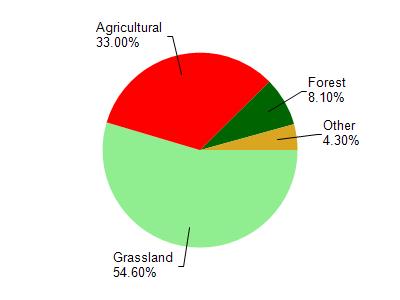
Brewery Creek is located in the Mineral Point and Sudan Branches watershed which is 108.26 mi². Land use in the watershed is primarily grassland (54.60%), agricultural (33%) and a mix of forest (8.10%) and other uses (4.30%). This watershed has 289.93 stream miles, 87.79 lake acres and 699.78 wetland acres.
Nonpoint Source Characteristics
This watershed is ranked Not Ranked for runoff impacts on streams, Not Ranked for runoff impacts on lakes and High for runoff impacts on groundwater and therefore has an overall rank of High. This value can be used in ranking the watershed or individual waterbodies for grant funding under state and county programs.However, all waters are affected by diffuse pollutant sources regardless of initial water quality. Applications for specific runoff projects under state or county grant programs may be pursued. For more information, go to surface water program grants.