Douglas
Yes
Yes
No
Fish and Aquatic Life
Overview
Cranberry Creek, in the Totagatic River Watershed, is a 4.05 mile river that falls in Douglas County. This river is an outstanding/exceptional resource water under NR102 as well as a Class I Trout Water under the Fisheries Program. This river is managed for fishing and swimming and is currently not considered impaired.
Date 2011
Author Aquatic Biologist
Condition
Wisconsin has over 84,000 miles of streams, 15,000 lakes and milllions of acres of wetlands. Assessing the condition of this vast amount of water is challenging. The state's water monitoring program uses a media-based, cross-program approach to analyze water condition. An updated monitoring strategy (2015-2020) is now available. Compliance with Clean Water Act fishable, swimmable standards are located in the Executive Summary of Water Condition in 2018. See also the 'monitoring and projects' tab.
Recommendations
Habitat Restoration - Shoreland
Practices include: fish sticks on 1 lakeshore property.
Best Management Practices, Implement
Minong Flowage Association will implement best practices described in Wisconsin's 2014-2017 Healthy Lakes Implementation Plan. Practices include: fish sticks 1 lakeshore property. The best practices require a contract to remain in effect for 10 years and must include minimum operation and maintenance requirements and data collection as described in grant condition #17.
Management Goals
Wisconsin's Water Quality Standards provide qualitative and quantitative goals for waters that are protective of Fishable, Swimmable conditions [Learn more]. Waters that do not meet water quality standards are considered impaired and restoration actions are planned and carried out until the water is once again fishable and swimmable
Management goals can include creation or implementation of a Total Maximum Daily Load analysis, a Nine Key Element Plan, or other restoration work, education and outreach and more. If specific recommendations exist for this water, they will be displayed below online.
Monitoring
Monitoring the condition of a river, stream, or lake includes gathering physical, chemical, biological, and habitat data. Comprehensive studies often gather all these parameters in great detail, while lighter assessment events will involve sampling physical, chemical and biological data such as macroinvertebrates. Aquatic macroinvertebrates and fish communities integrate watershed or catchment condition, providing great insight into overall ecosystem health. Chemical and habitat parameters tell researchers more about human induced problems including contaminated runoff, point source dischargers, or habitat issues that foster or limit the potential of aquatic communities to thrive in a given area. Wisconsin's Water Monitoring Strategy was recenty updated.
Grants and Management Projects
| Project Name (Click for Details) | Year Started |
|---|
| TOWN OF WASCOTT: Cranberry Lake EWM Rapid Response | 2007 |
| GORDON/ST. CROIX FLOWAGE ASSOCIATION: Gordon-St. Croix Flowage CLP/EWM AIS Education Project | 2010 |
| MINONG FLOWAGE ASSOCIATION: Minong Flowage 2016-2017 EWM Management Support Project | 2016 |
| MINONG FLOWAGE ASSOCIATION: Minong Flowage 2010-2012 EWM Education, Management, Assessment & Control Project | 2009 |
| TOWN OF MINONG: Town of Minong 2016 Clean Boats Clean Waters | 2016 |
| CRANBERRY LAKE/FLOWAGE ASSOCIATION: Cranberry Lake Douglas County AIS Control, 2016-2017 | 2016 |
| MINONG FLOWAGE ASSOCIATION: Minong Flowage Association 2020 CBCW | 2020 |
| MINONG FLOWAGE ASSOCIATION: Minong Flowage Association 2021 CBCW | 2021 |
| MINONG FLOWAGE ASSOCIATION: Minong Flowage APM Plan | 2007 |
| MINONG FLOWAGE ASSOCIATION: Minong Flowage Association 2017 CBCW | 2017 |
| MINONG FLOWAGE ASSOCIATION: Minong Flowage Association 2018 CBCW | 2018 |
| MINONG: Minong 2023 CBCW (Gilmore, Horseshoe, Nancy, Kimball, Sand, Flowage) | 2023 |
| MINONG FLOWAGE ASSOCIATION: Minong Flowage Association 2024 CBCW | 2024 |
| TOWN OF MINONG: Town of Minong 2021 CBCW (Big Sand, Gilmore, Horseshoe, Kimball, Minong Flowage, Nancy) | 2021 |
| MINONG FLOWAGE ASSOCIATION: HLR - Minong Flowage - Fish Sticks 2020-2023 | 2021 |
| TOWN OF MINONG: Town of Minong 2015 Clean Boats Clean Waters Project | 2015 |
| TOWN OF MINONG: Minong 2017 Nancy Lake & Minong Flowage CBCW | 2017 |
| TOWN OF MINONG: Town of Minong 2022 CBCW (Gilmore, Horseshoe, Nancy, Kimball, Sand, Flowage) | 2022 |
| WASHBURN COUNTY: HLR - Washburn County Shoreline Improvments | 2022 |
| MINONG FLOWAGE ASSOCIATION: Minong Flowage EWM Control Project, 2009-2011 | 2009 |
| MINONG FLOWAGE ASSOCIATION: HLk-Minong Flowage: Fish-Sticks Dan Maxwell | 2015 |
| MINONG FLOWAGE ASSOCIATION: Minong Flowage Clean Boats Clean Waters Project 2014 | 2014 |
| MINONG FLOWAGE ASSOCIATION: 2014 Aquatic Plant Monitoring & AIS Education Project | 2014 |
| MINONG FLOWAGE ASSOCIATION: Minong Flowage 2015 Clean Boats Clean Waters Project | 2015 |
| MINONG FLOWAGE ASSOCIATION: Minong Flowage Association 2016 Clean Boats Clean Water | 2016 |
| MINONG FLOWAGE ASSOCIATION: Minong Flowage Association 2023 CBCW | 2023 |
| MINONG: Minong 2024 CBCW | 2024 |
| MINONG FLOWAGE ASSOCIATION: 2024 Minong Flowage AIS Management Planning Project | 2024 |
| CRANBERRY LAKE/FLOWAGE ASSOCIATION: Cranberry Lake/Flowage Eurasian Watermilfoil Rapid Response 2009-2011 | 2009 |
| TOWN OF MINONG: Town of Minong Clean Boats Clean Waters Project 2014 (9 Lakes) | 2014 |
| MINONG FLOWAGE ASSOCIATION: 2018-2019 Drawdown to Control EWM in the Minong Flowage | 2018 |
| TOWN OF MINONG: Town of Minong 2020 CBCW (Gilmore, Horseshoe, Nancy, Kimball, Sand, Flowage) | 2020 |
| MINONG FLOWAGE ASSOCIATION: 2021-23 Minong Flowage Winter Drawdown Project | 2021 |
| MINONG FLOWAGE ASSOCIATION: Minong Flowage Association 2022 CBCW | 2022 |
|
Monitoring Projects
| WBIC | Official Waterbody Name | Station ID | Station Name | Earliest Fieldwork Date | Latest Fieldwork Date | View Station | View Data |
|---|
|
|
Watershed Characteristics
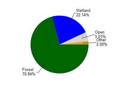
Cranberry Creek is located in the Totagatic River watershed which is 329.93 mi². Land use in the watershed is primarily forest (70.70%), wetland (22.10%) and a mix of open (5%) and other uses (2.00%). This watershed has 275.08 stream miles, 6,681.38 lake acres and 42,970.25 wetland acres.
Nonpoint Source Characteristics
This watershed is ranked Not Ranked for runoff impacts on streams, Not Ranked for runoff impacts on lakes and Low for runoff impacts on groundwater and therefore has an overall rank of Low. This value can be used in ranking the watershed or individual waterbodies for grant funding under state and county programs.However, all waters are affected by diffuse pollutant sources regardless of initial water quality. Applications for specific runoff projects under state or county grant programs may be pursued. For more information, go to surface water program grants.