Douglas
No
No
Yes
Fish and Aquatic Life
Overview
The Nemadji River drains 430 square miles of Minnesota and Wisconsin and carries a tremendous sediment load to Superior Bay, where it enters the Duluth-Superior Harbor near the Burlington Northern Ore Docks in Superior. Natural and human-induced erosion have caused the Nemadji River and its tributaries to cut deep valleys into the red clays of the watershed. Movement of soil material downhill due to gravity--slumping--is severe, and occurs in many locations adjacent to rivers. A sediment budget done for the Nemadji River Basin indicates that 98 percent of the sediment delivered to the harbor comes from bluff erosion along streams (NRCS 1996). Much of this soil material enters the stream system and is ultimately carried to the Duluth-Superior Harbor and Lake Superior. The Duluth-Superior Harbor was originally shallow, and must be dredged to maintain channels for ship traffic. On average, 23,000 tons of silt and clay, and 14,000 tons of sand are dredged per year due to the Nemadji River. About 94,000 tons of silt and clay annually, or 260 tons daily, are carried into Lake Superior (Lensch). This is the equivalent of 17 dump truck loads of silt and clay being dumped into Lake Superior daily. Sedimentation can cause the choking of spawning beds and carry contaminants and nutrients with them that can degrade aquatic habitat.
Clinging to sediment can be other contaminants or oxygen-demanding materials. Monitoring data from U.S. Geological Survey gauging stations and WDNR indicate periodically high inputs of bacteria at levels in excess of state standards for contact, and phosphorus levels high enough to promote algal growth.
While red clay erosion is natural, human activities in the last century have accelerated the natural process. Among those activities is the removal of forest cover that held soils in place. Recommendations from the St. Louis River System RAP's erosion and sedimentation technical advisory committee focused on implementing management recommendations that would moderate the rapid runoff from upland areas, which produces flash flooding in the Nemadji and its tributaries. The recommendations deal with a long-term process of managing forest cover to reduce surface runoff rates, and reestablishing natural drainage patterns to modify flooding and erosion in the watershed.
The mouth of the Nemadji River is an area of side-channel wetlands that extend for about a mile upstream. Wetlands at the mouth of the Nemadji cover about 90 acres that supports the spawning of several warm water fish species, including muskellunge. This area is identified by the Lake Superior Binational Program as important habitat to the Lake Superior ecosystem for coastal wetlands and fish and wildlife spawning and nursery grounds.
The Burlington Northern Railroad Co. operates a taconite pellet transfer facility with a permitted effluent discharge near the mouth of the Nemadji via an unnamed tributary and wetland at T49N R13W S31/32. At this site, taconite arrives by rail and is transferred by a conveyor system to ships docked in Superior Bay. Taconite may be temporarily stored on site prior to transfer. The discharge is primarily from storm water runoff and groundwater discharge. This tributary and wetland area is proposed for inclusion in the update of NR104 as waters that support limited aquatic life.
Lakehead Pipe Line Co. discharges to the Nemadji River via a drainage ditch. We have no file information to describe the effluent path or to identify the outlet location. Regional staff report it is an intermittent discharge used for hydrostatic testing (Larson).
From: Turville-Heitz, Meg. 1999. Lake Superior Basin Water Quality Management Plan. Wisconsin Department of Natural Resources, Madison, WI.
Date 1999
Author Aquatic Biologist
Historical Description
In May, 1994, a stipulated agreement with Burlington Northern railroad resulted in a settlement of which $220,000 was available for restoration of the water environment and fish and wildlife resources. Citizens of the Superior area told WDNR that the highest priority for settlement funds should be for environmental education. The funds resulted in seed money for an environmental education center for the Superior Municipal Forest; enhanced restoration and management of the common tern, an endangered species in the Superior area; and a one year grant to Lake Superior River Watch, an environmental education program that was supported in the past in some Superior schools by state and federal funds. Proposals would expand the River Watch program throughout Superior schools and potentially into regional schools. The RAP has recommended continued funding of the River Watch program as a means of educating citizens in the area of concern and acting as an outreach component of the RAP. Additional projects are under consideration.
Nemadji River Basin Project
The St. Louis River RAP recommended that the agencies secure funding to implement recommendations generated by the Nemadji River Basin Project. These recommendations will forward the goal of reducing sediment inputs from the Nemadji River watershed. An original recommendation in the 1992 iteration of the RAP called for a basin project to reduce erosion and sedimentation, with a watershedwide focus, determinations of the extent and causes of runoff problems and strategies to implement practices that would reduce erosion and sedimentation. The RAP also recommended the project should build on previous work such as the Red Clay project, and include the entire watershed. The Red Clay Research and Demonstration Project, concluded in the 1970s, looked at the properties of the red clay soils, the effect of vegetation on the soils, and tested a variety of stabilization projects. The Red Clay Project focused much of its effort on engineering solutions to streambank erosion. The project concluded that 90 percent of the sediment discharged to Lake Superior originated in 2 percent of the area, namely streambanks, channels and gullies (Lensch). While the erosion area is small, the study didn't look at the hydrologic conditions that increase peak flow and volumes, and thus increase streambank erosion (NRCS January, 1994).
One suggested compounding influence on the erosion and sedimentation in the Nemadji River is the combined influences of urbanization and the apparent shift in forest composition from conifer to deciduous, leading to higher peak flows in the river. (NRCS Feb. 25, 1994). While 90 percent of the watershed is forested, the forest adjacent to streams may not be an effective sediment filter, or may not form a sturdy enough root system to hold soils in place. Many red clay slumps in the watershed still move down hill despite tree cover, likely due to shallow groundwater movement beneath the root zone. The riparian areas along the stream vary dramatically in width and quality. Different types of trees, their age and understory can effect the stabilization effect of the forest cover. (NRCS January 1994).
From: Turville-Heitz, Meg. 1999. Lake Superior Basin Water Quality Management Plan. Wisconsin Department of Natural Resources, Madison, WI.
Date 1999
Author Aquatic Biologist
Historical Description
The Nemadji River Basin Project, funded primarily by the Natural Resources Conservation Service (formerly Soil Conservation Service) and the U.S. Forest Service, will not only generate information about the river, but also provide a recommended remedial measures to correct identified problems. The RAP recommended Minnesota DNR and WDNR take the lead in implementing recommendations from the project and identified potential sources of federal and state funding, including considering the watershed for priority watershed status under Wisconsin's Nonpoint Source Water Pollution Abatement Program.
The two-year Nemadji River Basin Project began in January of 1994. WDNR has taken an active role, with staff facilitating project development and coordination among the many agencies and groups involved in the project. The project uses a voluntary approach for adoption of a cleanup plan to restore beneficial uses in the watershed. WDNR staff have been involved in developing practices for land use, soil management and forestry that will help protect and improve water quality condition. Staff have also provided assistance with wildlife, fish and water resources management issues. Data provided by the project will be used to rank the basin for priority watershed selection. It is WDNR's expectation that sufficient cause exists to believe the watershed could benefit from priority watershed status, which enables WDNR to form partnerships with local government and provide financial incentives to implement of best-management practices that protect water quality. Due to the number of watersheds already selected or involved in the program, this watershed could not be elected before the year 2001.
Among project objectives are collect and analyze data for development of a remedial action plan for the watershed and best-management practices; inform and educate citizens about problems in the watershed and potential solutions; implement a public participation plan and improve multi-agency cooperation.
WDNR intends to apply recommendations that come out of the Nemadji Basin Project to other watersheds in the basin that
experience the problems associated with red clay.
From: Turville-Heitz, Meg. 1999. Lake Superior Basin Water Quality Management Plan. Wisconsin Department of Natural Resources, Madison, WI.
Date 1999
Author Aquatic Biologist
Recommendations
Water Quality Modeling
Addressing excess sedimentation impairments in the Nemadji River Basin with hspf scenario modeling
Information and Education
The St. Louis River Citizens Action Committee will conduct an organizational development and informational & educational project in the St. Louis and Nemadji River watersheds in Douglas County. Activities involved with this project include; distribution and dissemination of informational and educational materials on the Nemadji River Basin Project and the St. Louis River Area of Concern and the Remedial Action Plan, conduct and support of workshops and workgroup activities, expansion of the organizations Internet site, creation of a "health scorecard" for rivers to increase public understanding, and increasing the membership and participation in the activities of the organization. Reports of ongoing project activities will be disseminated via newsletter(s) or brochures(s), meeting(s), and the preparation of a final report.
Sewer Service Area Planning
TMDL Implementation
Implement actions that will help in attaining the AOC Delisting Targets.
Monitor or Propose 303(d) Listing
Contaminated sediment data collected in 2007 should be analyzed and used in future impaired waters evaluations.
Monitor Targeted Area
Continue monitoring for sediment and phosphorus in the Nemadji River and its tributaries.
Monitor Fish Tissue
Determine if a specific fish consumption advisory is needed for the Nemadji River by collecting fish tissue data. The adjacent St. Louis River has a fish consumption advisory for mercury and PCBs. Fish tissue data on the Nemadji, however, has not been obtained since the 1980s, and data were only obtained at the mouth of the river. Additionally, contaminants have been found in water column data for the Nemadji River that exceed several water quality standards. Suspected contaminants include mercury, PCBs, dieldrin, DDT, and 2,3,7,8-TCDD. Koppers Creek is a known upstream contaminant source for PAHs and dioxin (including 2,3,7,8-TCDD). This data will help to determine if a specific fish consumption advisory should be issued for the Nemadji River.
TMDL Development
Support Minnesota in their TMDL study for the Nemadji River, and support implementation actions to reduce sediment loads in the Nemadji River.
Habitat Restoration - Instream
Inventory, assess, and analyze habitat enhancement/rehabilitation opportunities in the St. Louis River and Lower Nemadji watershed.
Management Goals
Wisconsin's Water Quality Standards provide qualitative and quantitative goals for waters that are protective of Fishable, Swimmable conditions [Learn more]. Waters that do not meet water quality standards are considered impaired and restoration actions are planned and carried out until the water is once again fishable and swimmable
Management goals can include creation or implementation of a Total Maximum Daily Load analysis, a Nine Key Element Plan, or other restoration work, education and outreach and more. If specific recommendations exist for this water, they will be displayed below online.
Monitoring
Monitoring the condition of a river, stream, or lake includes gathering physical, chemical, biological, and habitat data. Comprehensive studies often gather all these parameters in great detail, while lighter assessment events will involve sampling physical, chemical and biological data such as macroinvertebrates. Aquatic macroinvertebrates and fish communities integrate watershed or catchment condition, providing great insight into overall ecosystem health. Chemical and habitat parameters tell researchers more about human induced problems including contaminated runoff, point source dischargers, or habitat issues that foster or limit the potential of aquatic communities to thrive in a given area. Wisconsin's Water Monitoring Strategy was recenty updated.
Grants and Management Projects
Monitoring Projects
| WBIC | Official Waterbody Name | Station ID | Station Name | Earliest Fieldwork Date | Latest Fieldwork Date | View Station | View Data |
|---|
| 2835300 | Nemadji River | 163233 | Nemadji River - 50 Yds Above Finn Rd Bridge | 9/9/1992 | 10/22/2015 | Map | Data |
| 2835300 | Nemadji River | 10015474 | Nemadji River- Upstream Hwy 35- Station #1 | 9/5/1997 | 9/5/1997 | Map | Data |
| 2835300 | Nemadji River | 163240 | Nemadji River - Spill Site | | | Map | Data |
| 2835300 | Nemadji River | 10044301 | Nemadji River - Station 6 - Chicago Northwestern RR Bridge | | | Map | Data |
| 2835300 | Nemadji River | 163239 | Nemadji River - Above Spill | | | Map | Data |
| 2835300 | Nemadji River | 163047 | Nemadji River at Cth W | 6/23/2009 | 1/1/2015 | Map | Data |
| 2835300 | Nemadji River | 10037076 | NEMADJI RIVER - WOODLAWN ROAD | 7/11/1992 | 8/6/2025 | Map | Data |
| 2835300 | Nemadji River | 163242 | Nemadji River - Woodlawn Bridge Site | | | Map | Data |
| 2835300 | Nemadji River | 10044435 | Nemadji River 15m DS Dedham Rd. | 1/1/2015 | 11/2/2015 | Map | Data |
| 2835300 | Nemadji River | 10018787 | Nemadji River -- Access | | | Map | Data |
| 2835300 | Nemadji River | 163019 | Newton Creek - Rr Xing At Mouth Superior | | | Map | Data |
| 2835300 | Nemadji River | 098 | Nemedji River - Mouth | 7/11/1974 | 7/11/1974 | Map | Data |
| 2835300 | Nemadji River | 163048 | Nemadji River at Sth 35 | 3/16/1978 | 11/2/2015 | Map | Data |
| 2835300 | Nemadji River | 163003 | Nemadji River at Cth C Near South Superior WI | 1/28/1974 | 8/6/2025 | Map | Data |
| 2835300 | Nemadji River | 10044300 | Nemadji River - Station 3A - Soo Line RR Bridge | | | Map | Data |
| 2835300 | Nemadji River | 10044299 | Nemadji River Old Hammond Ave Bridge | | | Map | Data |
| 2835300 | Nemadji River | 163243 | Nemadji River - Mouth | | | Map | Data |
| 2835300 | Nemadji River | 10044397 | Nemadji River 3 miles DS CTH C | 1/1/2015 | 10/22/2015 | Map | Data |
| 2835300 | Nemadji River | 10034073 | Nemadji River Macro & Water Quality 2 | | | Map | Data |
| 2835300 | Nemadji River | 10038135 | Nemadji River 440' DS Hwy W | 6/13/2012 | 1/1/2015 | Map | Data |
| 2835300 | Nemadji River | 10030022 | Nemadji River Macroinvertebrate station ~665 meters above Finn Rd. | 5/11/2009 | 1/1/2015 | Map | Data |
| 2835300 | Nemadji River | 10047910 | Nemadji River -- Nemadji River Landing | 11/6/2013 | 11/6/2013 | Map | Data |
| 2835300 | Nemadji River | 10002131 | Nemadji River - 05 Superior | 6/29/2010 | 9/7/2015 | Map | Data |
| 2835300 | Nemadji River | 10044302 | Nemadji River - Station 5 - Grand Ave Launch | | | Map | Data |
| 2835300 | Nemadji River | 163049 | Nemadji River at Sth 2-53 | 8/11/2014 | 8/6/2025 | Map | Data |
| 2835300 | Nemadji River | 10038134 | Nemadji River 300' DS Finn Rd bridge | 6/12/2012 | 1/1/2015 | Map | Data |
|
Watershed Characteristics
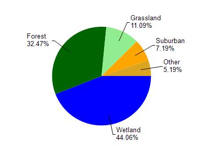
Nemadji River is located in the St. Louis and Lower Nemadji River watershed which is 159.67 mi². Land use in the watershed is primarily wetland (44.10%), forest (32.50%) and a mix of grassland (11.10%) and other uses (12.40%). This watershed has 432.66 stream miles, 8,490.75 lake acres and 26,945.85 wetland acres.
Nonpoint Source Characteristics
This watershed is ranked Not Ranked for runoff impacts on streams, Not Available for runoff impacts on lakes and Low for runoff impacts on groundwater and therefore has an overall rank of Low. This value can be used in ranking the watershed or individual waterbodies for grant funding under state and county programs.However, all waters are affected by diffuse pollutant sources regardless of initial water quality. Applications for specific runoff projects under state or county grant programs may be pursued. For more information, go to surface water program grants.