Details
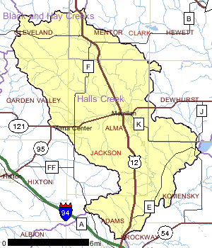
The Halls Creek watershed encompasses approximately 115 square miles of Jackson and Clark counties. Due to its fairly level topography, the area around Alma Center contains much of the agricultural lands. The percent of land in this watershed devoted to agriculture is less than half. Of the 110 stream miles in the Halls Creek watershed, 40 are Class I and II trout streams. Increased stream water temperatures caused by discharge from impoundments limit the biological use potential for much of the remaining stream miles. Three major impoundments exist in this watershed: Emerson Lake on East Fork Halls Creek and Oakwood and Trow Lakes in short succession on Halls Creek. Streambank pasturing exists in some areas, but is not a pervasive problem. Steep canyon-like walls buffer much of lower Halls Creek. The DNR owns over 800 acres of land adjacent to Halls Creek above Merrillan, known as the Halls Creek State Fishery Area.
Date 1999
Nonpoint and Point Sources
A recent water resource survey of the streams in this watershed revealed that several streams rank high regarding problems associated with non-point pollution. However, many more stream miles in this watershed rank low or medium. A non-point source priority watershed project would not be recommended for the entire watershed. However, a project that concentrated on the high ranked streams should result in improved stream conditions.
Date 1999

Ecological Landscapes
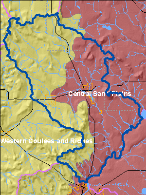
The Halls Creek Watershed is located in two ecological landscapes: the Western Coulee and Ridges and the Central Sand Plains.
The Western Coulee and Ridges Ecological Landscape in southwestern and west central Wisconsin is characterized by its highly eroded, driftless topography and relatively extensive forested landscape. Soils are silt loams (loess) and sandy loams over sandstone residuum over dolomite. Several large rivers including the Wisconsin, Mississippi, Chippewa, Kickapoo and Black flow through or border the Ecological Landscape.
Historical vegetation consisted of southern hardwood forests, oak savanna, scattered prairies, and floodplain forests and marshes along the major rivers. With Euro-American settlement, most of the land on ridgetops and valley bottoms was cleared of oak savanna, prairie, and level forest for agriculture. The steep slopes between valley bottom and ridgetop, unsuitable for raising crops, grew into oak-dominated forests after the ubiquitous presettlement wildfires were suppressed. Current vegetation is a mix of forest (40%), agriculture, and grassland with some wetlands in the river valleys. The primary forest cover is oak-hickory (51%) dominated by oak species and shagbark hickory. Maple-basswood forests (28%), dominated by sugar maple, basswood and red maple, are common in areas that were not subjected to repeated presettlement wildfires. Bottomland hardwoods (10%) are common in the valley bottoms of major rivers and are dominated by silver maple, ashes, elms, cottonwood, and red maple. Relict conifer forests including white pine, hemlock and yellow birch are a rarer natural community in the cooler, steep, north slope microclimates.
The Central Sand Plains Ecological Landscape, located in central Wisconsin, occurs on a flat, sandy lake plain, and supports agriculture, forestry, recreation, and wildlife management. The Ecological Landscape formed in and around what was once Glacial Lake Wisconsin, which contained glacial meltwater extending over 1.1 million acres at its highest stage. Soils are primarily sandy lake deposits, some with silt-loam loess caps. Sandstone buttes carved by rapid drainage of the glacial lake, or by wave action when they existed as islands in the lake, are distinctive features of this landscape.
The historic vegetation of the area included extensive wetlands of many types, including open bogs, shrub swamps, and sedge meadows. Prairies, oak forests, savannas and barrens also occurred in the Ecological Landscape. An area of more mesic forest with white pine and hemlock was found in the northwest portion, including a significant pinery in eastern Jackson County. Today, nearly half of the Ecological Landscape is nonforested, in agriculture and grassland. Most of the historic wetlands were drained early in the 1900s and are now used for vegetable cropping. The forested portion is mostly oak-dominated forest, followed by aspen and pines. A minor portion is maple-basswood forest and lowland hardwoods.
Date 2010
Wildlife and Habitat
Two aquatic dependent species of concern have been documented in this watershed. Management decisions should consider potential affects to these species. Other species may be present but not yet documented.
Date 1999
Watershed Recommendations
Date
Status
Collect chemical, physical, and/or biological water quality data to assess the current overall stream health. The data can inform management decisions and may be used to identify impaired waters for biennial lists.
6/5/2013
In Progress
Monitor biology on WBIC: 1727100
Date
Status
Conduct biological (mIBI or fIBI) monitoring on Unnamed, WBIC: 1727100, AU:3995225
5/21/2016
Proposed
Date
Status
DNR water program staff should conduct a fishery survey on
Creek 12-6 (West (South?) Fork Halls Creek).
7/1/2013
Proposed
Confirm FCA: IW pre-2000 data
Date
Status
1676700 name Black River, Hwy H To Rock Creek TMDL ID 50 Start Mile 98.14 End Mile 107.12
11/21/2011
Proposed
Cisna Creek TP
Date
Status
New 303(d) Listing for TP (5P). There are 3 years worth of data (2014, 2015, and 2016) so this could be listed for TP even though it's 'May Exceed'. 2018 TP Results: May Exceed. Station: 10013422. AU: 14227.
1/1/2018
Proposed
Date
Status
WDNR staff should continue to encourage communities to develop wellhead protection plans in the Watershed and the whole basin.
7/1/2010
Proposed
Mead Lake TMDL
Date
Status
TMDL Development for Mead Lake in Clark County, WI. Mead Lake is highly eutrophic and exhibits excessive concentrations of phosphorus and chlorophyll (a measure of algal densities) in its surface waters during the summer months (USACE 2005). Sediment and phosphorus enters the lake via the South Fork Eau Claire River, from nonpoint sources of pollution.
7/1/2007
In Progress
 Watershed History Note
The Hall Creek Watershed includes the communities of Alma Center and Merrillan. Merillan is known as the Christmas Tree Village and also has an interesting railroad history. The West Wisconsin Railroad was built through this portion of Jackson County in the fall of 1869. Trains on the West Wisconsin Railroad did not make stops at Merrillan at this time and passengers got off the trains at Wright's Mill (about 5 miles south) or at Humbird and then walked to Merrillan. Leander Merrill sent his brother Benjamin to Hudson, where the railroad offices were then located, in an effort to convince the railroad to change their road bed enough to include the present site of Merrillan. According to stories handed down by the Merrill family, the railroad officials agreed to change their route to include Merrill's future town for the consideration of $75,000, which Leander promptly paid to the company.
When the Green Bay and Lake Pepin Railroad planned to build their road through Jackson County, L.G. Merrill donated many acres of land to the company so they would change their plans from connecting with the West Wisconsin at Wright's Mill to connecting with the railroad in Merrillan. The Green Bay and Lake Pepin Railroad reached Merrillan on December 22, 1872, and the first train arrived here the following week with a Mr. Garvin as engineer.
The telegraph line on the railroad was completed in January 1873. A crude shack was converted into a Union Depot and both the West Wisconsin and Green Bay railroad began passenger service here. The first depot agent was J.A. Maynard. Merrillan's growth was very rapid after receiving passenger service.
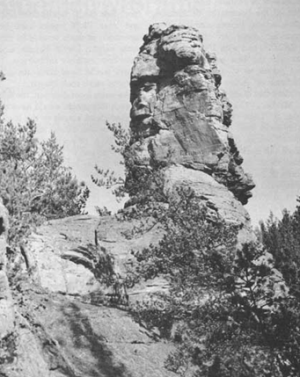
Photos at right - Pinnacle 30 ft. high above its left shoulder - is located the north end of Bruce Mound, 2 miles east of Merrillan, Clark County. The pinnacle is at an elevation of about 1240 ft, well above the level of Glacial Lake Wisconsin but several miles within the boundary of the older drift. It is believed to have formed since glaciation of the mound. From http://www.nps.gov
Date 2010