Details
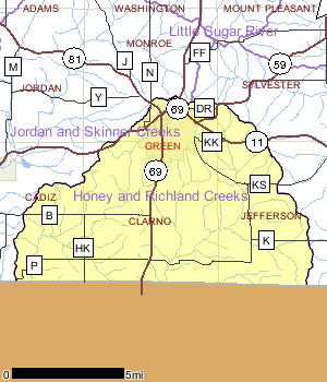
The Honey and Richland Creeks Watershed lies in south central Green County adjoining the Wisconsin/Illinois border. Both Honey and Richland Creeks run south into Illinois where they eventually join the Pecatonica River. Land use in the watershed is dominated by agriculture with almost 80% of the land cover devoted to agricultural practices. The most pressing issue for the watershed is habitat impairment from nonpoint source pollution.
For the Honey Creek catchment, approximately 80 percent of the watershed is in agriculture with a number of dairy operations. Excessive stream bank pasturing lends itself to habitat degradation by causing sedimentation, which covers hard substrate, and trampled down banks which make the stream wider and shallower. Runoff of manure adds nutrients which lead to algal and macrophyte growth.
Date 2015
Population, Land Use
The overall population of the watershed was 12,450 in the year 2000, with most of those (10,843) living in the city of Monroe. The population of Monroe has already exceeded projections out to the year 2015. The city, in conjunction with surrounding townships, Southwest Wisconsin Regional Planning Commission, and the DNR are working on a sewer service area plan that is designed not only to look at growth over the next 20 years, but also to keep development away from environmentally sensitive areas, with the primary goal of protecting water quality.
Date 2002
Nonpoint and Point Sources
The Monroe sewerage treatment facility discharges to Honey Creek and is the only municpal wastewater discharger to a surface water. Four industrial facilities also discharge to surface water in the watershed.
In addition to the Monroe Sewerage Treatment Plant, several industries discharge small amounts of non-contact cooling water to Honey Creek and its watershed. Honey Creek also exhibited fish kills in the past some caused by upsets of the Monroe sewerage treatment plant. Improvements to the plant in the 1980�s vastly improved the operations. However, the treatment plant does add nutrients to the system which encourages plant and algal growth.
Date 2015

Ecological Landscapes
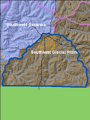
The Southeast Glacial Plains Ecological Landscape makes up the bulk of the non-coastal land area in southeast Wisconsin. This Ecological Landscape is made up of glacial till plains and moraines. Most of this Ecological Landscape is composed of glacial materials deposited during the Wisconsin Ice Age, but the southwest portion consists of older, pre-Wisconsin till with a more dissected topography. Soils are lime-rich tills overlain in most areas by a silt-loam loess cap. Agricultural and residential interests throughout the landscape have significantly altered the historical vegetation. Most of the rare natural communities that remain are associated with large moraines or in areas where the Niagara Escarpment occurs close to the surface.
Historically, vegetation in the Southeast Glacial Plains consisted of a mix of prairie, oak forests and savanna, and maple-basswood forests. Wet-mesic prairies, southern sedge meadows, emergent marshes, and calcareous fens were found in lower portions of the Landscape. End moraines and drumlins supported savannas and forests. Agricultural and urban land use practices have drastically changed the land cover of the Southeast Glacial Plains since Euro-American settlement. The current vegetation is primarily agricultural cropland. Remaining forests occupy only about 10% of the land area and consist of maple-basswood, lowland hardwoods, and oak. No large mesic forests exist today except on the Kettle Interlobate Moraine which has topography too rugged for agriculture. Some existing forest patches that were formerly savannas have succeeded to hardwood forest due to fire suppression.
Date 2010
Wetland Health
Wetland Status
The Honey and Richland Creeks Watershed lies in south central Green County adjoining the Wisconsin/Illinois border. Both Honey and Richland Creeks run south into Illinois where they eventually join the Pecatonica River. An estimated 1% of the current land uses in the watershed are wetlands. Roughly, 4% of the original wetlands in the watershed are estimated to exist. Of these wetlands, emergent wetlands (62%), which include wet meadows and marshes, and forested wetlands (33%) dominate the landscape.
Wetland Condition
Little is known about the condition of the remaining wetlands but estimates of reed canary grass infestations, an opportunistic aquatic invasive wetland plant, into different wetland types has been estimated based on satellite imagery. This information shows that reed canary grass dominates 96% of the existing emergent wetlands, which include wet meadows and marshes, and 4% of the remaining forested wetlands. Reed Canary Grass domination inhibits successful establishment of native wetland species.
Wetland Restorability
Of the 1,094 acres of estimated lost wetlands in the watershed, approximately 91% are considered potentially restorable based on modeled data, including soil types, land use and land cover (Chris Smith, DNR, 2009).
Date 2010
Rivers and Streams
All Waters in WatershedWatershed Trout StreamsWatershed Outstanding & Exceptional ResourcesLakes and Impoundments
Impaired Waters
List of Impaired WatersMonitoring & ProjectsProjects including grants, restoration work and studies shown below have occurred in this watershed. Click the links below to read through the text. While these are not an exhaustive list of activities, they provide insight into the management activities happening in this watershed.
Monitoring Studies
Very little data has been collected on streams in the watershed over the last 10 years. The most recent monitoring conducted was in 1996 on Honey Creek in response to a fish kill. Prior to that, the most extensive monitoring occurred in 1988 where monitoring of aquatic insects was conducted on several creeks in the region.
Date 2002
Watershed Recommendations
Date
Status
Watershed Planning Update
12/1/2009
In Progress
Honey Creek TMDL Monitoring
Date
Status
Monitor Honey Creek (892300) for habitat impairment caused by sedimentation. Conduct fisheries IBI and habitat assessment Honey Creek (3 sites) and one site on each of 3 major tributaries. Conduct monthly nutrient analysis (12) of Honey Creek below WWTP outfall. Conduct watershed assessment to determine sediment sources. Conduct macroinvertebrate analysis at 6 sites.
8/27/2006
In Progress