Waukesha
No
No
Yes
Fish and Aquatic Life
Overview
Lac La Belle is a 1,164-acre mesotrophic, natural drainage lake on the Oconomowoc River in Waukesha County (WDNR, 1994). Its shoreline has been extensively developed and urban polluted runoff is a problem. There is a lack of good natural habitat for fish reproduction, resulting in the need to stock game fish (WDNR, 1994). Non-native Eurasian watermilfoil dominates the aquatic vegetation. The lake will be sampled twice a year, every five years.
Rosenow Creek and an unnamed stream are additional tributaries. A grill structure on the outlet maintains water levels and deters rough fish movement. The fishery in the lake consists of northern pike, largemouth bass, pan fish and walleyes. Muskellunge have become established through downstream movement from Okauchee. Other species are yellow perch, smallmouth bass and bullhead. Aquatic plants are not considered a major use problem. Attempts have been made to increase the diversity of aquatic plants in the lake and curb growth of Eurasian water milfoil. The overabundant carp population prompted WDNR staff to implement a control program involving rotenone poisoning, panfish and flathead catfish stocking, and habitat improvement projects including walleye spawning reefs and half logs. Ample access is provided by city parks and streets, however, access is difficult on the west and north shores.
The Lac La Belle Lake Management District is very active. Members have organized a nonprofit conservation organization dedicated to preserving the natural resources around Lac La Belle. They have also participated in developing and implementing an Eurasian watermilfoil control program to increase the diversity of aquatic vegetation in the lake. They have aggressively tackled poor erosion control practices and stormwater management concerns. They have been willing participants in carp control projects and habitat improvement projects sponsored by WDNR.
In 1990, WDNR water resources managers identified sensitive areas on Lac La Belle. Any area with significant aquatic vegetation was identified as a sensitive area because of the overall scarcity and low aquatic plant diversity in the lake. The management implications for these areas included discontinuing the use of aquatic herbicides, pea gravel, aquatic plant screens, concrete, timber or steel seawalls.
In 1991, the Lac La Belle Lake Management District received a Wisconsin Lake Management Planning Grant to conduct surveys of riparian boat use, lake use, public access availability, comparison of 1990 creel survey, water quality analysis and inlake sensitive areas mapping. The results included a final report and a guidebook that provided lake management district residents with information on the water quality of Lac La Belle and how their actions affect the lake.
Adult zebra mussels have been identified in Lac La Belle.
Date 2002
Author Aquatic Biologist
Historical Description
Source: 1963, Surface Water Resources of Waukesha County Lac Labelle T8N, R17E,
A large natural drainage lake on the Oconomowoc River. Rosenow Creek and an unnamed stream are added water sources. A grill structure on the outlet maintains water levels and provides a deterrent to rough fish movement. The fishery consists of northern pike, largemouth bass, pan fish and walleyes. other species are yellow perch, smallmouth bass and bullheads. Weeds are a major-use problem; carp are common but do not pose a serious use problem at present. Ample access is provided by city parks and streets in oconomowoc, however, access is difficult on the west and north shores.. The population dynamics of the walleye are currently under study by the Fishery Research Section of the Wisconsin Conservation Department.
Surface Acres - 1, 117, S.D.F. = 1.90, Maximum Depth = 46 feet
Date 1963
Author Surface Water Inventory Of Wisconsin
Impaired Waters
Lac La Belle (848800) was placed on the impaired waters list for PCBs in 1998. Lac La Belle has been evaluated for phosphorus and algae every two years between 2014 and 2020. Phosphorus levels were found to be too high for healthy plant, bug, and fish communities. in 2020. This lake is on the impaired waters list.
Date 2015
Author Aaron Larson
Condition
Wisconsin has over 84,000 miles of streams, 15,000 lakes and milllions of acres of wetlands. Assessing the condition of this vast amount of water is challenging. The state's water monitoring program uses a media-based, cross-program approach to analyze water condition. An updated monitoring strategy (2015-2020) is now available. Compliance with Clean Water Act fishable, swimmable standards are located in the Executive Summary of Water Condition in 2018. See also the 'monitoring and projects' tab.
Reports
Recommendations
Easement/Buffer
The Village of Lac La Belle will purchase conservation easements on three Alan Runyard properties in an effort to reduce sediment and phosphorus that flow into Lac La Belle through the Golf Course Stream on the north side of the lake by implementation of best management practices. BMPs include buffer strips planted with native vegetation, clearing of invasive species, and stream bank stabilization.
Best Management Practices, Implement
The Village of Lac La Belle will hire contractors to implement BMPs on properties located in the Village and the Town of Oconomowoc including buffer strips planted with native vegetation, clearing of invasive species, stream bank stabilization and construction of a water quality basin that will intercept runoff and allow pollutants to be removed through settling. It is anticipated that all project elements will be constructed by October 2012 with monitoring of sediment and phosphorus to follow to verify water quality conditions and lasting until the summer of 2013.
Shoreland Monitoring, Assessment, Inventory
The City of Oconomowoc will implement a shoreline stabilization project on the Community Center Island located on LacLaBelle Lake. Biologs will be placed along the shoreline, and native plants will be placed in the biologs and along the shoreline. Non-native plants (purple loosestrife, box elder, etc.) will be removed.
Land Acquisition
The Lac La Belle Environmental Foundation will acquire one acre of land on Lake Lac La Belle in Waukesha County for the protection and improvement of the water quality of the lake.
Best Management Practices, Implement
The Village of Lac La Belle will hire contractors to implement BMPs on properties located in the Village and the Town of Oconomowoc including buffer strips planted with native vegetation, clearing of invasive species, stream bank stabilization and construction of a water quality basin that will intercept runoff and allow pollutants to be removed through settling.
Management Goals
Wisconsin's Water Quality Standards provide qualitative and quantitative goals for waters that are protective of Fishable, Swimmable conditions [Learn more]. Waters that do not meet water quality standards are considered impaired and restoration actions are planned and carried out until the water is once again fishable and swimmable
Management goals can include creation or implementation of a Total Maximum Daily Load analysis, a Nine Key Element Plan, or other restoration work, education and outreach and more. If specific recommendations exist for this water, they will be displayed below online.
Monitoring
Monitoring the condition of a river, stream, or lake includes gathering physical, chemical, biological, and habitat data. Comprehensive studies often gather all these parameters in great detail, while lighter assessment events will involve sampling physical, chemical and biological data such as macroinvertebrates. Aquatic macroinvertebrates and fish communities integrate watershed or catchment condition, providing great insight into overall ecosystem health. Chemical and habitat parameters tell researchers more about human induced problems including contaminated runoff, point source dischargers, or habitat issues that foster or limit the potential of aquatic communities to thrive in a given area. Wisconsin's Water Monitoring Strategy was recenty updated.
Grants and Management Projects
Monitoring Projects
| WBIC | Official Waterbody Name | Station ID | Station Name | Earliest Fieldwork Date | Latest Fieldwork Date | View Station | View Data |
|---|
| 848800 | Lac La Belle | 10047571 | Lac La Belle wetland drainage north | 1/1/2015 | 8/25/2017 | Map | Data |
| 848800 | Lac La Belle | 10047570 | Lac La Belle wetland drainage west | 1/1/2015 | 8/2/2017 | Map | Data |
| 848800 | Lac La Belle | 683125 | Lac La Belle - Deep Hole-Site 1 | 9/18/1973 | 6/18/2026 | Map | Data |
| 848800 | Lac La Belle | 10017478 | Lac La Belle -- Access | 9/7/2003 | 7/3/2026 | Map | Data |
| 848800 | Lac La Belle | 10050684 | Lac La Belle - south shore near Islandale Drive | | | Map | Data |
| 848800 | Lac La Belle | 10039836 | Lac La Belle at Oconomowoc WI | 2/14/2001 | 9/2/2025 | Map | Data |
| 848800 | Lac La Belle | 10047569 | Lac La Belle wetland drainage east | 1/1/2015 | 8/25/2017 | Map | Data |
| 848800 | Lac La Belle | 683171 | Lac La Belle - Nw Basin-Site 2 | 8/13/1989 | 6/18/2026 | Map | Data |
| 848800 | Lac La Belle | 10007170 | Lac La Belle | 9/1/1993 | 6/4/2026 | Map | Data |
| 848900 | Rosenow Creek | 10047377 | Wetland [ID 68423692251] | 9/21/2017 | 9/21/2017 | Map | Data |
| 848800 | Lac La Belle | 10041748 | Lac LaBelle Central Basin | 6/9/1992 | 6/9/1992 | Map | Data |
| 848800 | Lac La Belle | 132 | Lac La Belle - Lake Lac La Belle | 8/4/1976 | 8/4/1976 | Map | Data |
| 848800 | Lac La Belle | 683390 | Lac La Belle - SE Basin Deep Hole - Site 3 | 7/23/1990 | 6/19/2022 | Map | Data |
|
Watershed Characteristics
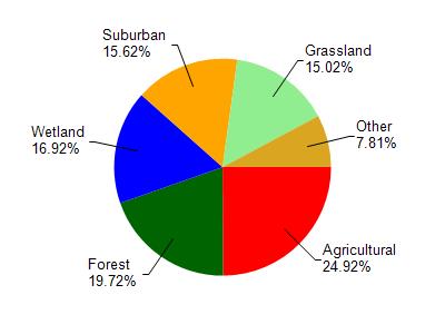
Lac La Belle is located in the Oconomowoc River watershed which is 130.86 mi². Land use in the watershed is primarily agricultural (24.90%), forest (19.70%) and a mix of wetland (16.90%) and other uses (38.40%). This watershed has 136.99 stream miles, 2,858.66 lake acres and 11,105.19 wetland acres.
Nonpoint Source Characteristics
This watershed is ranked Not Available for runoff impacts on streams, Not Available for runoff impacts on lakes and High for runoff impacts on groundwater and therefore has an overall rank of High. This value can be used in ranking the watershed or individual waterbodies for grant funding under state and county programs.However, all waters are affected by diffuse pollutant sources regardless of initial water quality. Applications for specific runoff projects under state or county grant programs may be pursued. For more information, go to surface water program grants.