Dane
No
No
Yes
Fish and Aquatic Life
Overview
The Yahara River flows into Lake Kegonsa, a large, highly eutrophic, moderately shallow drainage lake. Lake Kegonsa was formed as glacial deposits dammed the Yahara River. It is the furthest downstream of all of the Yahara River lakes and has a surface area of 3,209 acres and a maximum depth of 31 feet. The Kegonsa dam maintains water levels between 843.0 and 843.5 based upon the 1929 datum. Lake Kegonsa is located outside of the central urban area and it is surrounded primarily by agricultural land. Except for about 1.5 miles of shoreline in public ownership, much of the shoreline is developed with seasonal cottages and year-round homes. Water quality has improved over the last 40 years since the Madison Metropolitan Sewerage District diverted wastewater from the area's lakes. Yet, excess sediment, nutrient and chloride loads from upstream lakes, from the Yahara River, Door Creek and surrounding agricultural land continue to affect the lake's water quality. Since the 1970s, phosphorus concentrations have declined in the lake, attributable to lower levels from upstream lakes. Despite overall reductions in nutrient loads, severe blue-green algae blooms still occur during summer, restricting beneficial aquatic plant growth. Such blooms result from temporary summer stratification and frequent mixing combined with excess nutrient and sediment loads. Lake Kegonsa is susceptible to mixing due to the shape of the lake and lack of significant macrophyte growth. The mixing action stirs up bottom sediment and effectively recycles the nutrients into the water column. These recycled nutrients contribute to the growth of blue-green algae.
The lake is highly turbid, but modest improvements in water clarity would allow limited growth of aquatic plants, benefiting the lake's fishery. Fish kills have occurred in the past, some attributable to natural causes while the cause of others remains undetermined. Fish sampling in Lake Kegonsa has detected toxic contaminants, but at levels below health concern standards. High fecal coliform levels found in the lake in 1987 were probably caused by numerous poor or failing septic systems around the lake. More recently, local governments have provided sewer service to development around the lake shoreline to eliminate possible pollutant discharges from septic tanks. The creation of sanitary districts around the lake and the construction of wastewater collection and treatment systems are expected to eliminate this source of pollution.
The health of the lake is also affected by the growth of undesirable, non-native, macrophyte plant growth. Eurasian watermilfoil (Myriophyllum spicatum) had been the dominant aquatic plant species and the lake is currently experiencing expanding beds of sago pondweed (Potamogeton pectinatus), wild celery (Vallisneria americana), and curlyleaf pondweed (Potamogeton crispus).
The lake supports waterfowl migration and waterfowl hunting is good. It also has an excellent, diverse warm water sport fishery. Walleye and northern pike are stocked in this lake. Some of the largest bass in the area are found in Lake Kegonsa. Bluegill and yellow perch are the most numerous non-game species captured. Commonly found species include: the longnose gar, northern pike, emerald shiner, golden shiner, common carp, bluntnose minnow, channel catfish, fathead minnow, brook silverside, bigmouth buffalo, black, yellow and brown bullhead, white bass, rock bass, green sunfish, pumpkinseed, bluegill, smallmouth and largemouth bass, white and black crappie, Iowa darter, yellow perch, logperch, walleye, freshwater drum, bowfin, and white sucker. The lake is intensively used by boaters, skiers, and swimmers. Access is also available though the Yahara River and numerous boat landings. Boat rentals are also available on the lake.
Date 2002
Author Aquatic Biologist
Overview
Dane County constructed the 10 foot dam at Lake Kegonsa s outlet in 1938 to control the water level of Lake Kegonsa and improve navigation. Like the Waubesa Dam, the dam holds a small head and is often open during the year. Dane County owns and operates the Kegonsa Dam, which maintains the water level of Lake Kegonsa between 843.0 and 843.5, MSL Datum. The Door Creek Drainage District has expressed interest in lowering the lake level to improve drainage. Such a change would require a consensus building effort to include a variety of users, many of whom prefer the current water levels. Water level records show that Lake Kegonsa s water level has often been higher than the maximum even when the dam is entirely open. Recently, Dane County dredged the railroad bridge opening downstream of the dam to improve the outflow from the dam. This may help lower the lake levels back into the range more quickly after heavy rains.
Date 2002
Author Aquatic Biologist
Historical Description
Source: 1985, Surface Water Resources of Dane County,WI: WI-DNR Lake Kegonsa - T6N, R10E
This large, moderately shallow drainage, lake was formed by morainic damming of the preglacial Yahara River. The natural water level is presently augmented by a structure maintaining a 2-ft head. Approximately 1.5 miles of shoreline are in public ownership, including a county park, a state park, and 900 acres of wetlands. The rest of-the shoreline is residential. The watershed as a whole, however, is highly agricultural. Water quality in Lake Kegonsa has improved over the last 20 years since diversion of wastewater from the Madison Metropolitan Sewerage District, although blue-green algae blooms and excessive weed growths continue. The Yahara River still contributes to thenutrient load. Undersized, poorly located, and neglected septic systems serving lake shore residents contribute some nutrients. Agricultural runoff to Lake Kegonsa is a significant source of nutrients and sediments, especially in the Door creek watershed. These sources of nutrients must be eliminated or controlled to improve the water quality in Lake Kegonsa. The lake supports an excellent, diverse warm water fishery. Northern pike, walleye, largemouth bass, channel catfish, panfish, crappies, white bass, and perch are commonly caught. Walleye and largemouth bass are stocked. Many forage species are also present, as are lake sturgeon. The lake has a history of rough fish problems. Waterfowl hunting is good and the lake is used heavily by boaters, skiers, and swimmers. Six boat ramps provide easy access to the lake. Access is also available through the Yahara River. Boat rentals are available on the lake. Fish species: longnose gar, lake sturgeon, northern pike, emerald shiner, golden shiner, common carp, bluntnose minnow, channel catfish, fathead minnow, brook silverside, bigmouth buffalo, black, yellow, and brown bullhead, white bass, rock bass, green sunfish, pumpkinseed, bluegill, smallmouth and largemouth bass, white and black crappie, Iowa darter, yellow perch, logperch, walleye, freshwater drum, bowfin, and white sucker.
Surface acres = 3,209, SDF = 1.30, Maximum depth 31 ft
Date 1985
Author Surface Water Inventory Of Wisconsin
General Condition
Lake Kegonsa State Park Beach was assessed for the 2018 listing cycle; E. coli data sample data were clearly below the 2018 WisCALM listing thresholds for the Recreation use. This beach was meeting this designated use and was not considered impaired.
Date 2017
Author Ashley Beranek
Impaired Waters
Lake Kegonsa was placed under a special fish consumption advisory for PFOS in 2020; this lake had a listing of PFOS in fish tissue placed on the 2022 Impaired Waters List.
Date 2022
Author Ashley Beranek
Impaired Waters
Lake Kegonsa (WBIC 802600) was placed on the impaired waters list for total phosphorus in 2012. The TMDL was approved by the U.S. EPA in 2011. The 2018 assessments showed continued impairment by phosphorus; new total phosphorus and chlorophyll-a sample data exceeded the 2018 WisCALM listing thresholds for the Recreation use and Fish and Aquatic Life use. Based on the most updated information, no change in the existing impaired waters listing was needed.
Date 2017
Author Ashley Beranek
Impaired Waters
Lake Kegonsa (802600) was placed on the impaired waters list for total phosphorus in 2012. The TMDL was approved by the U.S. EPA in 2011. The 2016 assessments showed continued impairment by phosphorus; total phosphorus sample data overwhelmingly exceed 2016 WisCALM listing thresholds for the Recreation use, and chlorophyll data exceed REC thresholds. Total phosphorus and chlorophyll data do not exceed Fish and Aquatic Life thresholds. Based on the most updated information, no change in existing impaired waters listing is needed.
Date 2015
Author Aaron Larson
Condition
Wisconsin has over 84,000 miles of streams, 15,000 lakes and milllions of acres of wetlands. Assessing the condition of this vast amount of water is challenging. The state's water monitoring program uses a media-based, cross-program approach to analyze water condition. An updated monitoring strategy (2015-2020) is now available. Compliance with Clean Water Act fishable, swimmable standards are located in the Executive Summary of Water Condition in 2018. See also the 'monitoring and projects' tab.
Reports
Recommendations
Lake Classification
Dane County Lake Classification-Phase 2: The Phase 1 classification grant classified all county lakes and streams. This grant will take the next step by developing a management program based on the classification.
Land Acquisition
Acquisition of the Vogts property will meet objectives of the Door Creek Wetlands Resource Protection Plan. This acquisition and the planned restoration of the wetland are expected to improve spawning habitat for northern pike in Lake Kegonsa and better control stormwater and run-off pollution entering Lake Kegonsa from Door Creek.
Land Acquisition
Dane County Parks Department is seeking funding for acquisition of the Bruns/Amundson Property in order to acquire 19 acres of land. Acquisition of this land will protect property immediately adjacent to other county and town owned lands.
Lake Classification
Dane County Department of Planning and Development will hire a project staff in order to develop a Lake Classification project, which is seen as the first step toward developing a consistent set of county-wide standards and procedures to protect Dane County Waters.
Land Acquisition
Dane County will purchase 80 acres of wetlands (The Ladd Property) in the Town of Dunn along the Door Creek Wetlands in order to preserve wildlife habitat and water quality.
Land Acquisition
Dane County will purchase 20 acres fee acquisition of wetlands (The Wheeler Property) in the Town of Dunn along the Door Creek Wetlands in order to preserve wildlife habitat and water quality.
Management Goals
Wisconsin's Water Quality Standards provide qualitative and quantitative goals for waters that are protective of Fishable, Swimmable conditions [Learn more]. Waters that do not meet water quality standards are considered impaired and restoration actions are planned and carried out until the water is once again fishable and swimmable
Management goals can include creation or implementation of a Total Maximum Daily Load analysis, a Nine Key Element Plan, or other restoration work, education and outreach and more. If specific recommendations exist for this water, they will be displayed below online.
Monitoring
Monitoring the condition of a river, stream, or lake includes gathering physical, chemical, biological, and habitat data. Comprehensive studies often gather all these parameters in great detail, while lighter assessment events will involve sampling physical, chemical and biological data such as macroinvertebrates. Aquatic macroinvertebrates and fish communities integrate watershed or catchment condition, providing great insight into overall ecosystem health. Chemical and habitat parameters tell researchers more about human induced problems including contaminated runoff, point source dischargers, or habitat issues that foster or limit the potential of aquatic communities to thrive in a given area. Wisconsin's Water Monitoring Strategy was recenty updated.
Grants and Management Projects
Monitoring Projects
| WBIC | Official Waterbody Name | Station ID | Station Name | Earliest Fieldwork Date | Latest Fieldwork Date | View Station | View Data |
|---|
| 802600 | Lake Kegonsa | 10017891 | Lake Kegonsa -- Access - Along Quam Dr SW End Of Lake | 8/12/2009 | 6/16/2012 | Map | Data |
| 802600 | Lake Kegonsa | 10030536 | Lake Kegonsa 2406 Co Hwy AB pier | 9/3/2009 | 9/5/2014 | Map | Data |
| 802600 | Lake Kegonsa | 10017889 | Lake Kegonsa -- Access - Aalseth Ln In The Town Of Dunn | 7/19/2007 | 10/5/2008 | Map | Data |
| 802600 | Lake Kegonsa | 10042264 | Lake Kegonsa - Barbers Bay | 7/11/2005 | 4/5/2024 | Map | Data |
| 802600 | Lake Kegonsa | 10030269 | Lake Kegonsa W shore Harmful Algae Bloom | 6/23/2009 | 6/23/2009 | Map | Data |
| 802600 | Lake Kegonsa | 10017838 | Lake Kegonsa State Park Boat Access | 6/6/2005 | 5/26/2026 | Map | Data |
| 802600 | Lake Kegonsa | 10017892 | Lake Kegonsa -- Access - SW Side Of Lake Off Barber Dr | 7/10/2008 | 7/10/2008 | Map | Data |
| 802600 | Lake Kegonsa | 10031508 | Lake Kegonsa SE side of lake | 7/12/2010 | 9/2/2014 | Map | Data |
| 802600 | Lake Kegonsa | 10042263 | Lake Kegonsa - North Bay | 6/27/2014 | 7/19/2016 | Map | Data |
| 802600 | Lake Kegonsa | 133522 | Lake Kegonsa - Lake Kegonsa State Park Beach | | | Map | Data |
| 802600 | Lake Kegonsa | 10021611 | Lake Kegonsa - B | 7/2/2007 | 7/2/2007 | Map | Data |
| 802600 | Lake Kegonsa | 10021617 | Lake Kegonsa - H | 7/2/2007 | 9/2/2014 | Map | Data |
| 802600 | Lake Kegonsa | 10044692 | Lake Kegonsa - Yahara River inlet | 6/5/2015 | 6/5/2015 | Map | Data |
| 802600 | Lake Kegonsa | 133331 | Lake Kegonsa - State Park Beach | 5/28/1985 | 7/7/2026 | Map | Data |
| 802600 | Lake Kegonsa | 095 | Yahara River at Lake Kegonsa | 6/25/1976 | 6/25/1976 | Map | Data |
| 802600 | Lake Kegonsa | 10017890 | Lake Kegonsa -- Amundsons Landing | 7/23/2009 | 5/26/2026 | Map | Data |
| 802600 | Lake Kegonsa | 10001206 | Lake Kegonsa | 3/20/1903 | 3/13/2026 | Map | Data |
| 802600 | Lake Kegonsa | 10017821 | Lake Kegonsa -- Access - Off Williams Point Dr. | 7/1/2007 | 5/26/2026 | Map | Data |
| 802600 | Lake Kegonsa | 10017835 | Fish Camp Launch Park Boat Ramp - Lake Kegonsa | 6/6/2005 | 7/6/2026 | Map | Data |
| 802600 | Lake Kegonsa | 10021613 | Lake Kegonsa - D | 7/2/2007 | 9/5/2014 | Map | Data |
| 802600 | Lake Kegonsa | 10021619 | Lake Kegonsa - J | 7/2/2007 | 9/3/2014 | Map | Data |
| 802600 | Lake Kegonsa | 10021612 | Lake Kegonsa - C | 7/2/2007 | 7/2/2007 | Map | Data |
| 802600 | Lake Kegonsa | 10017822 | Lake Kegonsa -- Access - Off Sunnyside St | 7/20/2007 | 10/4/2008 | Map | Data |
| 802600 | Lake Kegonsa | 10021616 | Lake Kegonsa - G | 7/2/2007 | 7/2/2007 | Map | Data |
| 802600 | Lake Kegonsa | 10021614 | Lake Kegonsa - E | 7/2/2007 | 7/2/2007 | Map | Data |
| 802600 | Lake Kegonsa | 10021610 | Lake Kegonsa - A | 7/2/2007 | 6/27/2017 | Map | Data |
| 802600 | Lake Kegonsa | 10021615 | Lake Kegonsa - F | 7/2/2007 | 6/11/2008 | Map | Data |
| 802600 | Lake Kegonsa | 10021618 | Lake Kegonsa - I | 7/2/2007 | 7/2/2007 | Map | Data |
| 802600 | Lake Kegonsa | 133122 | Lake Kegonsa - Deep Hole | 5/23/1973 | 6/15/2026 | Map | Data |
|
Watershed Characteristics
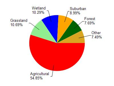
Lake Kegonsa is located in the Yahara River and Lake Kegonsa watershed which is 126.33 mi². Land use in the watershed is primarily agricultural (54.90%), grassland (10.70%) and a mix of wetland (10.30%) and other uses (24.20%). This watershed has 145.73 stream miles, 3,600.04 lake acres and 6,832.19 wetland acres.
Nonpoint Source Characteristics
This watershed is ranked Medium for runoff impacts on streams, Low for runoff impacts on lakes and High for runoff impacts on groundwater and therefore has an overall rank of High. This value can be used in ranking the watershed or individual waterbodies for grant funding under state and county programs.However, all waters are affected by diffuse pollutant sources regardless of initial water quality. Applications for specific runoff projects under state or county grant programs may be pursued. For more information, go to surface water program grants.