Oneida
No
No
Yes
Fish and Aquatic Life
Overview
Bearskin Lake , in the Middle Tomahawk River Watershed, is a 402.69 acre lake that falls in Oneida County. This lake is managed for fishing and swimming and is currently considered impaired.
Date 2015
Author Aquatic Biologist
Historical Description
Source: 1966, Surface Water Resources of Oneida County Bearskin Lake, T37N, R6E, Section 1 Surface Acres = 383.7, S.D.F. = 2.16, Maximum Depth=26 feet.
A soft water drainage lake having slightly acid, clear water of moderate transparency. Gravel and rubble are the principal littoral materials (40 percent) with muck (35 percent) and sand (20percent) also constituting a major portion of the bottom materials with a limited area of boulders. The shoreline is predominantly upland (95 percent) with a limited bog-meadow wetland adjoining the lake basin. Muskellunge, northern pike, walleye, largemouth bass, smallmouth bass, perch, bluegill, crappie, rock bass, pumpkinseed, bullhead and sucker inhabit this lake. Public access facilities with parking is provided. Navigable stream access is also available. Commercial facilities consist of six resorts, Forty-four dwellings and a public campground are also to be found on this lake. Mallard and black duck utilize this lake for nesting sites. Puddle ducks and diving ducks use this lake on their fall migration.
Date 1966
Author Surface Water Inventory Of Wisconsin
Impaired Waters
Bearskin Lake (WBIC 1523600) was placed on the impaired waters list for excess algal growth in 2012. The 2018 assessments showed continued excess algal growth; new chlorophyll-a sample data exceeded the 2018 WisCALM listing thresholds for the Recreation use. Total phosphorus data were clearly below the Recreation use and Fish and Aquatic Life use listing thresholds. Based on the most updated information, no change in the existing impaired waters listing was needed.
Date 2017
Author Ashley Beranek
Impaired Waters
Bearskin Lake (1523600) was placed on the impaired waters list for total phosphorus and excess algal growth in 2012. The 2016 assessments showed continued excess algal growth; chlorophyll sample data exceed 2016 WisCALM listing thresholds for the Recreation use, however, total phosphorus were clearly below REC thresholds. Total phosphorus and chlorophyll data were clearly below Fish and Aquatic Life listing thresholds. Based on the most updated information, the total phosphorus pollutant was proposed for deletion, but excess algal growth remained.
Date 2015
Author Aaron Larson
Condition
Wisconsin has over 84,000 miles of streams, 15,000 lakes and milllions of acres of wetlands. Assessing the condition of this vast amount of water is challenging. The state's water monitoring program uses a media-based, cross-program approach to analyze water condition. An updated monitoring strategy (2015-2020) is now available. Compliance with Clean Water Act fishable, swimmable standards are located in the Executive Summary of Water Condition in 2018. See also the 'monitoring and projects' tab.
Reports
Recommendations
Develop/Distribute Brochures/Literature
Develop/Distribute Newsletter
Issue News/Media Release
Shoreland Monitoring, Assessment, Inventory
Shoreland Monitoring, Assessment or Inventory
Informational Meetings
Lake Management Plan Development
Aquatic Invasive Species Removal
BIG BEARSKIN LAKE ASSOCIATION: Bearskin Lake Stewardship Program, Phase 2
Watercraft Inspections Clean Boats, Clean Waters
Hold Workshops
Lakes Planning Grant
Issue News/Media Release
Develop/Distribute Newsletter
Information and Education
Informational Meetings
Water Quality Planning
The Big Bearskin Lake Association will conduct a lake water quality improvement program with the goal of increasing water clarity and resulting sechi disc readings This project will use barley straw to inhibit blue-green algae growth in the lake. Anticipated results include improvement in water transparency and aquatic plant growth and distribution through out the lake.
Specific activities of this project include the installation of the straw bales, water quality monitoring, and aquatic plant survey, and development of a final report.
County Land and Water Management Plan
Town of Hazelhurst proposes to develop a comprehensive land use plan and implementation strategies to address the land and water issues in the Town. The Town proposes to work closely with Oneida County's lake classification program to create a land use plan that matches appropriate land uses with the specific class of lakes in the watershed.
Management Goals
Wisconsin's Water Quality Standards provide qualitative and quantitative goals for waters that are protective of Fishable, Swimmable conditions [Learn more]. Waters that do not meet water quality standards are considered impaired and restoration actions are planned and carried out until the water is once again fishable and swimmable
Management goals can include creation or implementation of a Total Maximum Daily Load analysis, a Nine Key Element Plan, or other restoration work, education and outreach and more. If specific recommendations exist for this water, they will be displayed below online.
Monitoring
Monitoring the condition of a river, stream, or lake includes gathering physical, chemical, biological, and habitat data. Comprehensive studies often gather all these parameters in great detail, while lighter assessment events will involve sampling physical, chemical and biological data such as macroinvertebrates. Aquatic macroinvertebrates and fish communities integrate watershed or catchment condition, providing great insight into overall ecosystem health. Chemical and habitat parameters tell researchers more about human induced problems including contaminated runoff, point source dischargers, or habitat issues that foster or limit the potential of aquatic communities to thrive in a given area. Wisconsin's Water Monitoring Strategy was recenty updated.
Grants and Management Projects
Monitoring Projects
| WBIC | Official Waterbody Name | Station ID | Station Name | Earliest Fieldwork Date | Latest Fieldwork Date | View Station | View Data |
|---|
| 1523600 | Bearskin Lake | 10020243 | Bearskin Lake -- Access | 7/5/2007 | 8/9/2023 | Map | Data |
| 1523600 | Bearskin Lake | 443121 | Bearskin Lake - Deep Hole | 8/14/1973 | 6/21/2026 | Map | Data |
| 1523600 | Bearskin Lake | 10004456 | Bearskin Lake | 7/27/1999 | 11/29/2025 | Map | Data |
|
Watershed Characteristics
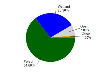
Bearskin Lake is located in the Middle Tomahawk River watershed which is 233.30 mi². Land use in the watershed is primarily forest (64.60%), wetland (26.90%) and a mix of open (7%) and other uses (1.50%). This watershed has 191.49 stream miles, 4,575.90 lake acres and 42,061.39 wetland acres.
Nonpoint Source Characteristics
This watershed is ranked Not Ranked for runoff impacts on streams, Low for runoff impacts on lakes and Low for runoff impacts on groundwater and therefore has an overall rank of Low. This value can be used in ranking the watershed or individual waterbodies for grant funding under state and county programs.However, all waters are affected by diffuse pollutant sources regardless of initial water quality. Applications for specific runoff projects under state or county grant programs may be pursued. For more information, go to surface water program grants.