Oneida
No
No
Yes
Fish and Aquatic Life
Overview
Pelican Lake, in the Pelican River Watershed, is a 3,544.79 acre lake that falls in Oneida County. This lake is managed for fishing and swimming and is currently considered impaired.
Date 2014
Author Ashley Beranek
Historical Description
Source: 1966, Surface Water Resources of Oneida County Pelican Lake, T35N, R10E, Section 23
A soft water drainage lake having slightly alkaline, clear water of moderate transparency. Sand (40 percent) and muck (30 percent) are the predominant littoral materials with gravel (20 percent) and rubble. The shoreline is predominantly upland (95 percent) with bog and meadow wetlands adjoining a limited portion of the lake basin. Submergent vegetation is moderate in density. Muskellunge, northern pike, walleye, largemouth bass, smallmouth bass, white bass, perch, bluegill, crappie, rock bass, pumpkinseed, bullhead and sucker are fish species inhabiting this lake. Public access with parking is available. Thirty-eight resorts, two private campgrounds and 284 dwellings are located on the shoreline. Mallard and black duck use this lake as a nesting site. Puddle ducks and diving ducks use this lake on their spring and fall migrations. Water levels are maintained by a water control structure of two feet head located on the outlet stream.
Surface Acres = 3,585, S.D.F. = 1.91, Maximum Depth = 39 feet
Date 1966
Author Surface Water Inventory Of Wisconsin
Recommendations
Informational Meetings
Lake Management Plan Development
Monitor Invasive Species
Social Survey of Residents or Users
Lakes Planning Grant
Lake Management Plan Development
Information and Education
Develop/Distribute Newsletter
Issue News/Media Release
Monitor Water Quality or Sediment
Watershed Mapping or Assessment
Project Deliverable
1) Stakeholder survey, news release(s), and newsletter article; 2) Water chemistry data; 3) Watershed maps and modeling data.
Shoreland Monitoring, Assessment, Inventory
Shoreland Monitoring, Assessment or Inventory
Lake Management Plan Development
Aquatic Plant Monitoring or Survey
Management Goals
Wisconsin's Water Quality Standards provide qualitative and quantitative goals for waters that are protective of Fishable, Swimmable conditions [Learn more]. Waters that do not meet water quality standards are considered impaired and restoration actions are planned and carried out until the water is once again fishable and swimmable
Management goals can include creation or implementation of a Total Maximum Daily Load analysis, a Nine Key Element Plan, or other restoration work, education and outreach and more. If specific recommendations exist for this water, they will be displayed below online.
Monitoring
Monitoring the condition of a river, stream, or lake includes gathering physical, chemical, biological, and habitat data. Comprehensive studies often gather all these parameters in great detail, while lighter assessment events will involve sampling physical, chemical and biological data such as macroinvertebrates. Aquatic macroinvertebrates and fish communities integrate watershed or catchment condition, providing great insight into overall ecosystem health. Chemical and habitat parameters tell researchers more about human induced problems including contaminated runoff, point source dischargers, or habitat issues that foster or limit the potential of aquatic communities to thrive in a given area. Wisconsin's Water Monitoring Strategy was recenty updated.
Grants and Management Projects
Monitoring Projects
| WBIC | Official Waterbody Name | Station ID | Station Name | Earliest Fieldwork Date | Latest Fieldwork Date | View Station | View Data |
|---|
| 1579900 | Pelican Lake | 443042 | Pelican Lake - Ep Ncd | 9/6/1979 | 9/6/1979 | Map | Data |
| 1579900 | Pelican Lake | 443140 | Pelican Lake - Deep Hole | 8/9/1973 | 5/7/2026 | Map | Data |
| 1579900 | Pelican Lake | 10018879 | Pelican Lake -- Keelers Landing - Cth Q | 9/30/2003 | 6/21/2026 | Map | Data |
| 1579900 | Pelican Lake | 443476 | Pelican Lake - Sabanois Point | 5/18/2004 | 10/3/2024 | Map | Data |
| 1579900 | Pelican Lake | 443477 | Pelican Lake - Indian Point | 8/22/1997 | 6/17/2023 | Map | Data |
| 1579900 | Pelican Lake | 10019829 | Pelican Lake -- Canoe Access - Nr Chicago Point Dr | 6/28/2018 | 6/28/2018 | Map | Data |
| 1579900 | Pelican Lake | 10046663 | Phragmites Occurrence - Pelican Lake | | | Map | Data |
| 1579900 | Pelican Lake | 10018622 | Pelican Lake -- State landing access at Near Cth G | 5/29/2004 | 6/21/2026 | Map | Data |
| 1579900 | Pelican Lake | 10018872 | Pelican Lake -- Access - Cth Q Nr Sabinois Point Dr | | | Map | Data |
| 1579900 | Pelican Lake | 444030 | Pelican Lake - Pelican Lake | 8/20/1979 | 8/20/1979 | Map | Data |
| 1579900 | Pelican Lake | 443514 | Pelican Lake - Treacherous Bay | 5/3/1997 | 6/17/2023 | Map | Data |
| 1579900 | Pelican Lake | 10019943 | Pelican Lake -- Boat Launch - Nr Cth Q | 5/6/2006 | 6/28/2018 | Map | Data |
| 1579900 | Pelican Lake | 10018871 | Pelican Lake -- Access Nr Hwy 45 | 7/16/2011 | 9/3/2023 | Map | Data |
| 1579900 | Pelican Lake | 10043763 | Pelican Lake -- Landing/pier on 45/47 behind Musky Mart | 7/4/2015 | 9/1/2025 | Map | Data |
| 1579900 | Pelican Lake | 443478 | Pelican Lake - Crescent Island | 6/3/2004 | 6/17/2023 | Map | Data |
| 1579900 | Pelican Lake | 443488 | Pelican Lake - North Of Island (South Of Deep Hole) | 5/18/2004 | 6/17/2023 | Map | Data |
| 1579900 | Pelican Lake | 10001448 | Pelican Lake (Oneida Co) | 12/30/1991 | 9/30/2017 | Map | Data |
|
Watershed Characteristics
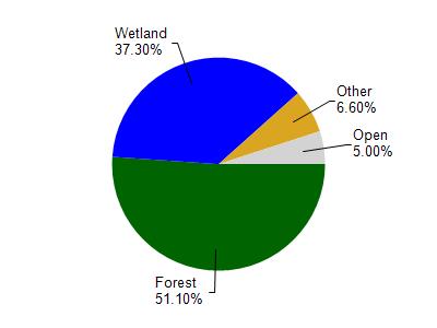
Pelican Lake is located in the Pelican River watershed which is 264.88 mi². Land use in the watershed is primarily forest (51.10%), wetland (37.30%) and a mix of open (5%) and other uses (6.60%). This watershed has 244.69 stream miles, 8,823.57 lake acres and 59,960.52 wetland acres.
Nonpoint Source Characteristics
This watershed is ranked Not Ranked for runoff impacts on streams, Medium for runoff impacts on lakes and Low for runoff impacts on groundwater and therefore has an overall rank of Low. This value can be used in ranking the watershed or individual waterbodies for grant funding under state and county programs.However, all waters are affected by diffuse pollutant sources regardless of initial water quality. Applications for specific runoff projects under state or county grant programs may be pursued. For more information, go to surface water program grants.